

Wilma slightly accelerates, Signal No. 1 raised over 18 areas
Tropical Depression Wilma slightly accelerates while moving in the west southwest direction over the Philippine Sea as Signal No. 1 is raised over 18 areas, according to the latest Tropical Cyclone Bulletin posted by PAGASA.
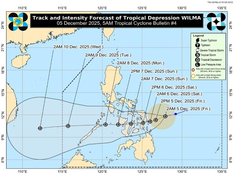
The center of Tropical Depression Wilma was estimated at 245 kilometers east of Borongan City, Eastern Samar packing maximum sustained winds of 45 kilometers per hour, gustiness of up to 55 km/h, and central pressure of 1,000 hPa.
Wilma is moving west southwestward at the speed of 20 km/h with strong winds extending outwards up to 220 kilometers from the center.
Tropical Cyclone Wind Signal (TCWS) No. 1 is hoisted over the following areas:
Luzon
- the southern portion of mainland Masbate (Cataingan, Pio V. Corpuz, Esperanza, Placer, Cawayan, Palanas, Dimasalang)
Visayas
- Northern Samar
- Eastern Samar
- Samar
- Biliran
- Leyte
- Southern Leyte
- the northern and central portions of Cebu (Daanbantayan, Medellin, City of Bogo, San Remigio, Tabogon, Borbon, Tabuelan, Tuburan, Sogod, Catmon, Asturias, Carmen, Danao City, Balamban, Compostela, Liloan, Consolacion, Cebu City, Mandaue City, Cordova, Lapu-Lapu City, Toledo City, Pinamungahan, San Fernando, City of Naga, Minglanilla, City of Talisay, Aloguinsan, City of Carcar, Sibonga, Barili, Alcantara, Ronda, Dumanjug, Argao, Moalboal, Badian, Dalaguete, Alcoy) including Bantayan and Camotes Islands
- Bohol
- the northern and eastern portions of Negros Occidental (Sagay City, City of Escalante, Toboso, Calatrava, Enrique B. Magalona, City of Victorias, Manapla, Cadiz City, Bacolod City, City of Talisay, Silay City, Salvador Benedicto, San Carlos City, Murcia, Bago City, La Carlota City, La Castellana, Moises Padilla)
- the northern portion of Negros Oriental (City of Guihulngan, Canlaon City, Vallehermoso, La Libertad)
- the eastern portion of Iloilo (San Dionisio, Estancia, Batad, Carles, Concepcion, Ajuy, Sara, Balasan, Lemery, Barotac Viejo, San Rafael)
- the eastern portion of Capiz (Pilar, President Roxas)
Mindanao
- Surigao del Norte including Siargao and Bucas Grande Islands
- Dinagat Islands
- the northern portion of Surigao del Sur (Carrascal, Cantilan, Madrid, Carmen, Lanuza)
- the northern portion of Agusan del Norte (Kitcharao, Jabonga, Santiago, Tubay, City of Cabadbaran, Remedios T. Romualdez, Magallanes)
- Camiguin
Heavy rainfall outlook due to Tropical Cyclone Wilma:
(100-200 mm): Northern Samar, Eastern Samar, Samar, Biliran, Leyte, and Southern Leyte
(50-100 mm): Cebu, Bohol, Negros Oriental, Negros Occidental, Siquijor, Guimaras, Iloilo, Capiz, Surigao del Norte, Dinagat Islands, Agusan del Norte, Misamis Oriental, Camiguin, Lanao del Norte, and Misamis Occidental
The Northeast Monsoon will also bring strong to gale-force gusts over the following areas not under Wind Signal (especially in coastal and upland areas exposed to winds) over most of Luzon and Visayas.
Gale Warning is in effect over the northern and western seaboards of Northern Luzon and the eastern seaboards of Luzon and Visayas.
"Wilma is forecast to move west southwestward until tomorrow (06 December) before turning generally westward for the remaining forecast period," said PAGASA.
The center of Wilma may make its initial landfall or pass close over Eastern Visayas or Dinagat Islands between Friday evening and Saturday morning then will continue to traverse Visayas until Sunday.
Wilma will then emerge over Sulu Sea and may pass over northern Palawan by Monday morning.
"WILMA will slightly intensify before landfall but will likely remain as a tropical depression throughout the forecast period. Further intensification is possible once it emerges over the West Philippine Sea." — BAP, GMA Integrated News
