

21 areas still under Signal No. 1 as Wilma slows down but holds strength
Twenty-one areas remained under Signal No. 1 as Tropical Depression Wilma slowed down while maintaining strength as it moves toward Eastern Visayas, according to state weather bureau PAGASA Friday afternoon.
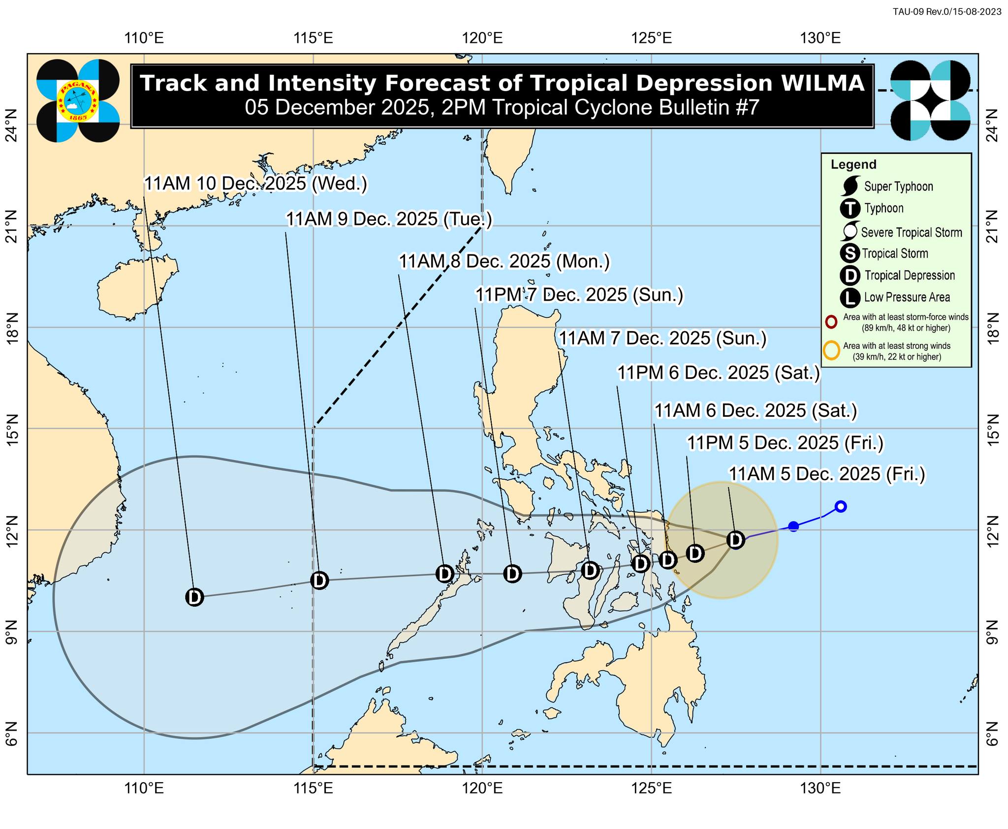
In its 2 p.m. advisory, PAGASA said Wilma is now moving west southwestward at 10 km/h from 15 km/h earlier in the day. It is packing maximum sustained winds of 45 km/h near the center, gustiness of up to 55 km/h, and central pressure of 1004 hPa
The center of Wilma was located 225 km east of Borongan City, Eastern Samar.
Areas still under Tropical Cyclone Wind Signal No. 1 are:
Luzon
- The southern portion of Sorsogon (Matnog, Bulan, Irosin, Santa Magdalena, Bulusan, Barcelona, Magallanes, Juban, Casiguran, Gubat), and
- mainland Masbate including Ticao Island
Visayas
- Northern Samar,
- Eastern Samar,
- Samar,
- Biliran,
- Leyte,
- Southern Leyte,
- Cebu including Bantayan and Camotes Islands,
- Bohol,
- the northern and central portions of Negros Occidental (Sagay City, City of Escalante, Toboso, Calatrava, Enrique B. Magalona, City of Victorias, Manapla, Cadiz City, Bacolod City, City of Talisay, Silay City, Salvador Benedicto, San Carlos City, Murcia, Bago City, La Carlota City, La Castellana, Moises Padilla, Valladolid, Pulupandan, San Enrique, Pontevedra, Hinigaran, Isabela, Binalbagan, City of Himamaylan, City of Kabankalan),
- Siquijor,
- the northern and central portions of Negros Oriental (City of Guihulngan, Canlaon City, Vallehermoso, La Libertad, Jimalalud, Tayasan, Ayungon, Bindoy, Manjuyod, Bais City, Pamplona, City of Tanjay, Amlan, San Jose, Dumaguete City, Valencia, Sibulan, Bacong, Mabinay),
- the eastern portion of Iloilo (San Dionisio, Estancia, Batad, Carles, Concepcion, Ajuy, Sara, Balasan, Lemery, Barotac Viejo, San Rafael, City of Passi, San Enrique, Anilao, Banate, Dingle, Barotac Nuevo, Mina, Pototan, New Lucena, Santa Barbara, Pavia, Iloilo City, Leganes, Zarraga, Dumangas, Dueñas),
- the eastern portion of Capiz (Pilar, President Roxas, Panay, Pontevedra, Ma-Ayon, Cuartero, Dumarao, Dao, Panitan, Roxas City), and
- Guimaras
Mindanao
- Surigao del Norte including Siargao and Bucas Grande Islands,
- Dinagat Islands,
- the northern portion of Surigao del Sur (Carrascal, Cantilan, Madrid, Carmen, Lanuza),
- the northern portion of Agusan del Norte (Kitcharao, Jabonga, Santiago, Tubay, City of Cabadbaran, Remedios T. Romualdez, Magallanes), and
- Camiguin
Track
Wilma is forecast to move west southwestward until Saturday, December 6, before turning generally westward for the remaining forecast period.
PAGASA said the center of Wilma may make its initial landfall over Eastern Visayas between Friday evening and Saturday morning.
It will continue to traverse Visayas until Sunday, December 7 and then emerge over Sulu Sea and may pass over northern Palawan by Monday morning, December 8.
The weather bureau said Wilma will likely remain as a tropical depression throughout the forecast period. Further intensification is possible once it emerges over the West Philippine Sea. —AOL, GMA Integrated News
