

Signal No. 1 hoisted in 21 areas as Wilma nears Eastern Visayas
Signal No. 1 remains hoisted in 21 areas nationwide as Tropical Depression Wilma maintains strength while moving towards Eastern Visayas.
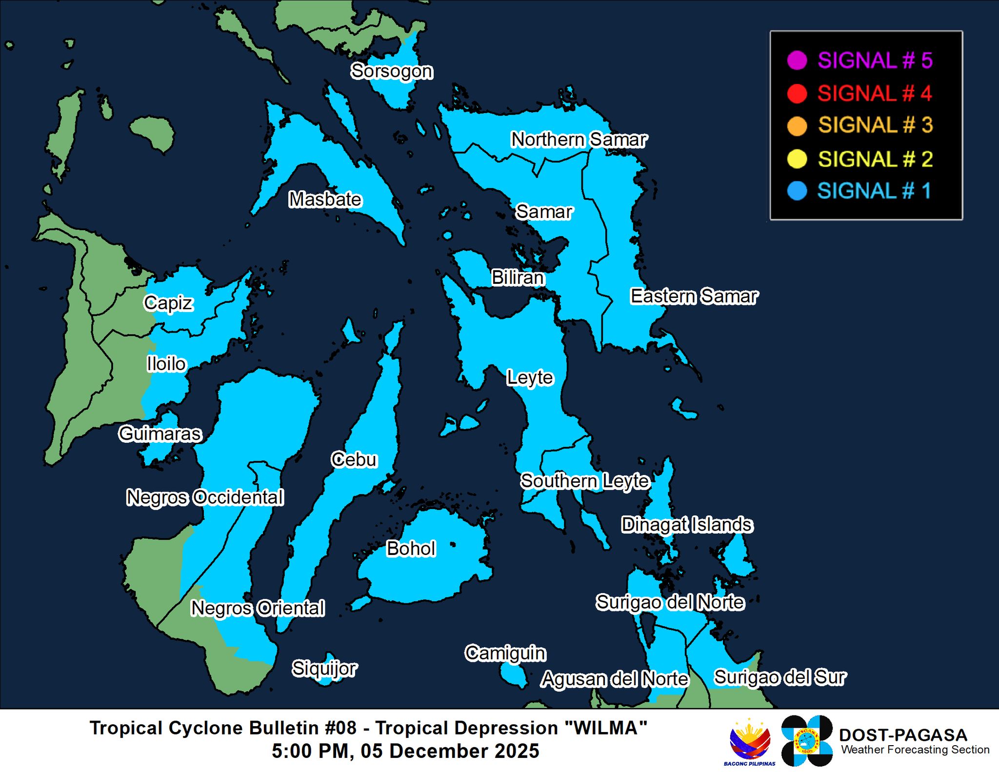
According to PAGASA’s 5 pm cyclone bulletin on Friday, the following areas under Signal No. 1 will have winds of 39 to 61 kph or intermittent rains within 36 hours:
- The southern portion of Sorsogon (Matnog, Bulan, Irosin, Santa Magdalena, Bulusan, Barcelona, Magallanes, Juban, Casiguran, Gubat)
- Mainland Masbate including Ticao Island
- Northern Samar
- Eastern Samar
- Samar
- Biliran
- Leyte
- Southern Leyte
- Cebu including Bantayan and Camotes Islands
- Bohol
- The northern and central portions of Negros Occidental (Sagay City, City of Escalante, Toboso, Calatrava, Enrique B. Magalona, City of Victorias, Manapla, Cadiz City, Bacolod City, City of Talisay, Silay City, Salvador Benedicto, San Carlos City, Murcia, Bago City, La Carlota City, La Castellana, Moises Padilla, Valladolid, Pulupandan, San Enrique, Pontevedra, Hinigaran, Isabela, Binalbagan, City of Himamaylan, City of Kabankalan)
- Siquijor
- The northern and central portions of Negros Oriental (City of Guihulngan, Canlaon City, Vallehermoso, La Libertad, Jimalalud, Tayasan, Ayungon, Bindoy, Manjuyod, Bais City, Pamplona, City of Tanjay, Amlan, San Jose, Dumaguete City, Valencia, Sibulan, Bacong, Mabinay)
- The northern and central portions of Iloilo (San Dionisio, Estancia, Batad, Carles, Concepcion, Ajuy, Sara, Balasan, Lemery, Barotac Viejo, San Rafael, City of Passi, San Enrique, Anilao, Banate, Dingle, Barotac Nuevo, Mina, Pototan, New Lucena, Santa Barbara, Pavia, Iloilo City, Leganes, Zarraga, Dumangas, Dueñas, Bingawan)
- The eastern and central portions of Capiz (Pilar, President Roxas, Panay, Pontevedra, Ma-Ayon, Cuartero, Dumarao, Dao, Panitan, Roxas City, Ivisan, Sigma, Sapi-An, Mambusao, Dumalag)
- Guimaras
- Surigao del Norte including Siargao and Bucas Grande Islands
- Dinagat Islands
- The northern portion of Surigao del Sur (Carrascal, Cantilan, Madrid, Carmen, Lanuza)
- The northern portion of Agusan del Norte (Kitcharao, Jabonga, Santiago, Tubay, City of Cabadbaran, Remedios T. Romualdez, Magallanes)
- Camiguin
“Minimal to minor impacts from strong winds are possible within any of the areas under Wind Signal No. 1,” read the bulletin.
“The wind signals warn the public of the general wind threat over an area due to the tropical cyclone. Local winds may be slightly stronger/enhanced in coastal and upland/mountainous areas exposed to winds. Winds are less strong in areas sheltered from the prevailing wind direction,” it added.
Most of Luzon, the Visayas, the Zamboanga Peninsula, and Misamis Occidental may also experience strong to gale-force gusts over the weekend, despite not being under any wind signal, due to the effects of the Northeast Monsoon.
As of 5 p.m., Wilma was last seen at 180 kilometers East of Borongan City, Eastern Samar, with maximum sustained winds of 45 kph and a gustiness of up to 55 kph.
It is expected to make an initial landfall over Eastern Visayas on Friday night or Saturday morning, then continue over the Sulu Sea and northern Palawan.
While it will most likely remain a tropical depression throughout its forecast period, heavy rainfall and severe winds may be expected in localities outside the landfall point and the forecast confidence cone. –NB, GMA Integrated News
