

Tropical Depression Wilma moving slowly, 23 areas under Signal No. 1
Tropical Depression Wilma is moving westward slowly as it heads to Eastern Visayas, PAGASA said in its 8 p.m. cyclone bulletin.
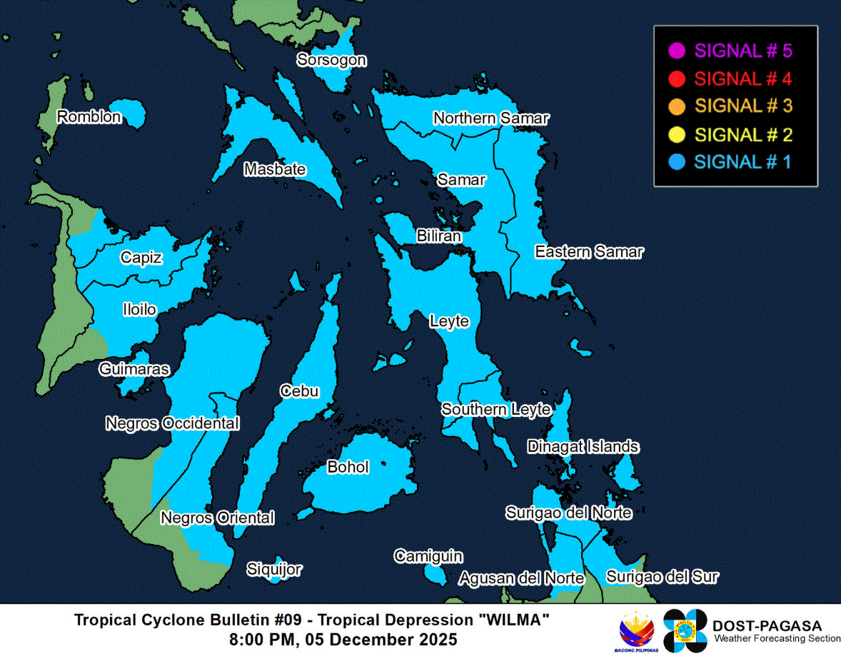
A total of 23 areas in Luzon, Visayas and Mindanao are under Signal No. 1, which will experience winds of 39 to 61 kilometers per hour or intermittent rains within 36 hours.
The following areas are under Signal No. 1:
Luzon
- the southern portion of Sorsogon (Matnog, Bulan, Irosin, Santa Magdalena, Bulusan, Barcelona, Magallanes, Juban, Casiguran, Gubat)
- mainland Masbate including Ticao Island
- and the eastern portion of Romblon (San Fernando, Cajidiocan, Magdiwang)
Visayas
- Northern Samar
- Eastern Samar
- Samar
- Biliran
- Leyte
- Southern Leyte
- Cebu including Bantayan and Camotes Islands
- Bohol
- the northern and central portions of Negros Occidental (Sagay City, City of Escalante, Toboso, Calatrava, Enrique B. Magalona, City of Victorias, Manapla, Cadiz City, Bacolod City, City of Talisay, Silay City, Salvador Benedicto, San Carlos City, Murcia, Bago City, La Carlota City, La Castellana, Moises Padilla, Valladolid, Pulupandan, San Enrique, Pontevedra, Hinigaran, Isabela, Binalbagan, City of Himamaylan, City of Kabankalan)
- Siquijor
- the northern and central portions of Negros Oriental (City of Guihulngan, Canlaon City, Vallehermoso, La Libertad, Jimalalud, Tayasan, Ayungon, Bindoy, Manjuyod, Bais City, Pamplona, City of Tanjay, Amlan, San Jose, Dumaguete City, Valencia, Sibulan, Bacong, Mabinay)
- Guimaras
- the northern and central portion Iloilo (San Dionisio, Estancia, Batad, Carles, Concepcion, Ajuy, Sara, Balasan, Lemery, Barotac Viejo, San Rafael, City of Passi, San Enrique, Anilao, Banate, Dingle, Barotac Nuevo, Mina, Pototan, New Lucena, Santa Barbara, Pavia, Iloilo City, Leganes, Zarraga, Dumangas, Dueñas, Bingawan, Lambunao, Calinog, Janiuay, Badiangan, Cabatuan, Maasin, Alimodian, San Miguel, Oton)
- Capiz
- the eastern portion of Aklan (Altavas, Batan, New Washington, Kalibo, Banga, Balete, Libacao, Madalag)
Mindanao
- Surigao del Norte including Siargao and Bucas Grande Islands
- Dinagat Islands
- the northern portion of Surigao del Sur (Carrascal, Cantilan, Madrid, Carmen, Lanuza)
- the northern portion of Agusan del Norte (Kitcharao, Jabonga, Santiago, Tubay, City of Cabadbaran, Remedios T. Romualdez, Magallanes)
- Camiguin
The center of the eye of Wilma was estimated 170 kilometers East of Borongan City, Eastern Samar, packed with maximum sustained winds of 45 km/h near the center and gustiness of up to 55 km/h.
According to PAGASA, Wilma is forecast to move west southwestward until Saturday before turning generally westward for the remaining forecast period.
On the forecast track, the center of Wilam may make its initial landfall over Eastern Visayas on Saturday. Afterwards, it will continue to traverse Visayas until Sunday. It will then emerge over Sulu Sea and may pass over northern Palawan by Monday morning.
"Wilma will likely remain as a tropical depression throughout the forecast period. Further intensification is possible once it emerges over the West Philippine Sea," PAGASA said. —LDF, GMA Integrated News
