

Signal No. 1 up over 27 areas as Wilma threatens to make landfall over Eastern Visayas
Tropical Cyclone Wind Signal (TCWS) No. 1 was hoisted over 27 areas on Saturday morning as Tropical Depression Wilma threatens to make its initial landfall over Eastern Visayas, PAGASA said.
TCWS No. 1 is in effect over the following areas as of posting time:
Sorsogon;
- Masbate including Ticao and Burias Islands;
- Romblon;
- the southern portion of Oriental Mindoro (Bulalacao, Mansalay, Roxas, Bongabong);
- the southern portion of Occidental Mindoro (Magsaysay, San Jose, Rizal, Calintaan);
- the northernmost portion of Palawan (Araceli, Dumaran, El Nido, Taytay) including Cuyo, Calamian;
- Cagayancillo Islands;
- Northern Samar;
- Eastern Samar;
- Samar;
- Biliran;
- Leyte;
- Southern Leyte;
- Cebu including Bantayan and Camotes Islands;
- Bohol;
- Negros Occidental;
- Siquijor;
- the northern and central portions of Negros Oriental (City of Guihulngan, Canlaon City, Vallehermoso, La Libertad, Jimalalud, Tayasan, Ayungon, Bindoy, Manjuyod, Bais City, Pamplona, City of Tanjay, Amlan, San Jose, Dumaguete City, Valencia, Sibulan, Bacong, Mabinay, City of Bayawan, Basay);
- Guimaras;
- Iloilo;
- Capiz;
- Aklan;
- Antique;
- Surigao del Norte including Siargao and Bucas Grande Islands;
- Dinagat Islands;
- the northern portion of Surigao del Sur (Carrascal, Cantilan, Madrid, Carmen, Lanuza);
- the northern portion of Agusan del Norte (Kitcharao, Jabonga, Santiago, Tubay, City of Cabadbaran, Remedios T. Romualdez, Magallanes); and
- Camiguin.
These areas will experience strong winds with speeds of 39 to 61 km/h in 36 hours, posing minimal to minor threat to life and property.
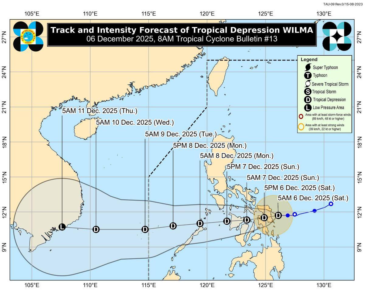
At 7 a.m., the center of Wilma was estimated to be located at 70 km east of Borongan City, Eastern Samar, packing maximum sustained winds of 45 km/h near the center, and with gustiness of up to 55 km/h and central pressure of 1004 hPa.
Wilma maintained its strength while over the sea east of Eastern Visayas. It is moving westward slowly, the weather bureau said. From its center, strong winds are extending outwards up to 220 km.
"On the forecast track, the center of WILMA may make its initial landfall over Eastern Visayas today," PAGASA said.
"Afterwards, it will continue to traverse Visayas until tomorrow (07 December). It will then emerge over Sulu Sea and may pass over northern Palawan by Monday (08 December) morning," the weather bureau added.
Rainfall
PAGASA said in its heavy rainfall outlook that Sorsogon, Masbate, Northern Samar, Eastern Samar, and Samar will have 100 to 200 mm of rainfall today due to Wilma.
Meanwhile, Romblon, Biliran, Leyte, Cebu, Negros Occidental, Aklan, Capiz, Iloilo, Guimaras, and Antique may expect 50 to 100 mm of rainfall today.
A shear line on the other hand will bring heavy to intense rains measuring 100 to 200 mm over Camarines Sur, Catanduanes, and Albay on Saturday.
Marinduque, Camarines Norte, and Quezon will have moderate to heavy rains measuring 50 to 100 mm on Saturday due to the shear line.
Winds
Strong to gale-force gusts may affect most of Luzon, Visayas, and Zamboanga Peninsula on Saturday due to the Northeast Monsoon (Amihan), especially in coastal and upland areas exposed to winds.
Gale warning, coastal waters
PAGASA raised a gale warning over the eastern seaboards of Luzon and Visayas.
Coastal waters meanwhile will be up to very rough over:
• Up to 5.5 m: The northern and eastern seaboards of Catanduanes; the eastern seaboards of Albay and Sorsogon; the northern seaboard of Northern Samar.
• Up to 5.0 m: The seaboards of mainland Cagayan, Isabela, and Aurora; the northern and eastern seaboards of Polillo Islands, Camarines Norte, and Camarines Sur; the remaining seaboard of Northern Samar.
• Up to 4.5 m: The eastern seaboards of Batanes, Babuyan Islands, and Eastern Samar.
"Sea travel is risky for all types or tonnage of vessels. All mariners must remain in port or, if underway, seek shelter or safe harbor as soon as possible until winds and waves subside," PAGASA said.
Up to rough seas meanwhile may be experienced over the following coastal waters, it said:
• Up to 4.0 m: The remaining seaboards of Batanes and Babuyan Islands; the seaboard of Ilocos Norte.
• Up to 3.5 m: The seaboards of Surigao del Sur and Kalayaan Islands.
• Up to 3.0 m: The remaining seaboards of Ilocos Region; the eastern seaboard of Davao Oriental.
"Mariners of small seacrafts, including all types of motorbancas, are advised not to venture out to sea under these conditions, especially if inexperienced of operating ill-equipped vessels," PAGASA said.
Up to moderate to rough seas on the other hand are forecast for:
• Up to 2.5 m: The western seaboards of Zambales, Bataan, Batangas, and Palawan; the seaboards of Cuyo Islands; the western seaboards of Antique and Negros Occidental; the southern seaboards of Oriental Mindoro, Negros Oriental, and Davao Occidental; the seaboards of Occidental Mindoro, Romblon, and Aklan.
• Up to 2.0 m: The remaining seaboards of Palawan, Quezon, and Camarines Sur; the seaboard of Marinduque; the northwestern seaboard of Masbate including Burias Islands; the remaining seaboard of Oriental Mindoro; the northern seaboard of Zamboanga del Norte.
"Mariners of motorbancas and similarly sized vessels are advised to take precautionary measures while venturing out to sea and, if possible, avoid navigation under these conditions," PAGASA said.
Intensity outlook
The weather bureau said Wilma may likely remain a tropical depression as it passes over Visayas and Southern Luzon.
Wilma however may further intensify once it emerges over the West Philippine Sea.
PAGASA advised the public and disaster risk reduction and management offices to take the necessary measures to protect life and property.
The next weather bulletin about Wilma will be issued by PAGASA at 11 a.m.
Shear line, Northeast Monsoon
Meanwhile, the eastern section of Southern Luzon is being affected on Saturday by a shear line, PAGASA said.
The rest of Bicol Region not being affected by Wilma, Quezon, Occidental Mindoro, Oriental Mindoro, and Marinduque will have cloudy skies with scattered rains and isolated thunderstorms due to a shear line. Moderate to heavy with at times intense rains may result in flash floods or landslides.
The rest of Luzon on the other hand is being affected by the Northeast Monsoon (Amihan).
Cagayan Valley, Cordillera Administrative Region, and Aurora may expect cloudy skies with rains due to the monsoon. Flash floods or landslides may possibly occur due to moderate to at times heavy rains.
Metro Manila and the rest of Luzon will have partly cloudy to cloudy skies with isolated light rains also due to the monsoon.
Meanwhile, the rest of Mindanao will experience partly cloudy to cloudy skies with isolated rain showers or thunderstorms due to localized thunderstorms. During severe thunderstorms, flash floods or landslides may result.
Sunrise was at 6:08 a.m. while sunset will be at 5:26 p.m. —KG, GMA Integrated News
