

Signal No. 1 up over 16 areas as Wilma moves over the coastal waters of Samar
Tropical Cyclone Wind Signal (TCWS) No. 1 was hoisted over 16 areas on Sunday morning as Tropical Depression Wilma began moving west southwestward while over the coastal waters of Samar, PAGASA said.
In its 8 a.m. tropical cyclone bulletin, the weather bureau said TCWS No. 1 is in effect over:
- Sorsogon;
- Masbate including Ticao and Burias Islands;
- Romblon;
- the southern portion of Oriental Mindoro (Bulalacao, Mansalay, Roxas, Bongabong,Bansud);
- the southern portion of Occidental Mindoro (Magsaysay, San Jose, Rizal, Calintaan,Sablayan);
- Northern Samar;
- the northern and central portions of Eastern Samar (Can-Avid, Maslog, City of Borongan, San Policarpo, Taft, Maydolong, Dolores, Jipapad, Oras, Arteche, Balangkayan, Sulat, San Julian);
- the northern and central portions of Samar (San Jorge, San Sebastian, Santa Rita, Villareal, Zumarraga, Matuguinao, Pinabacdao, Almagro, Calbayog City, Talalora, Jiabong, Pagsanghan, City of Catbalogan, Gandara, Motiong, Santo Niño, Tagapul-An, San Jose de Buan, Santa Margarita, Tarangnan, Calbiga, Daram, Paranas, Basey, Hinabangan);
- Biliran;
- the northern portion of Leyte (Tunga, San Miguel, Matag-Ob, Calubian, Leyte, Carigara, Babatngon, Jaro, San Isidro, Santa Fe, Villaba, Capoocan, Alangalang, Tabango, Tacloban City, Kananga, Barugo, Palo, Pastrana);
- the northern portion of Cebu (Daanbantayan, Medellin, City of Bogo, San Remigio, Tabogon) including Bantayan Islands;
- the northern portion of Negros Occidental (Sagay City, City of Escalante, Enrique B. Magalona, City of Victorias, Manapla, Cadiz City);
- the central and eastern portions of Iloilo (San Dionisio, Estancia, Batad, Carles, Concepcion, Ajuy, Sara, Balasan, Lemery, Barotac Viejo, San Rafael, City of Passi, San Enrique, Anilao, Banate, Dingle, Barotac Nuevo, Mina, Pototan, New Lucena, Santa Barbara, Leganes, Zarraga, Dumangas, Dueñas, Bingawan, Lambunao, Calinog, Janiuay, Badiangan, Cabatuan, Maasin, Alimodian, San Miguel, Leon, Tubungan, Igbaras);
- Capiz;
- Aklan, and
- the northern and central portions of Antique (Patnongon, Sibalom, Barbaza, Valderrama, Pandan, San Jose, Bugasong, Culasi, Sebaste, Tibiao, San Remigio, Libertad, Belison, Laua-An, Hamtic) including Caluya Islands.
"Minimal to minor impacts from strong winds are possible within any of the areas under Wind Signal No. 1," PAGASA said.
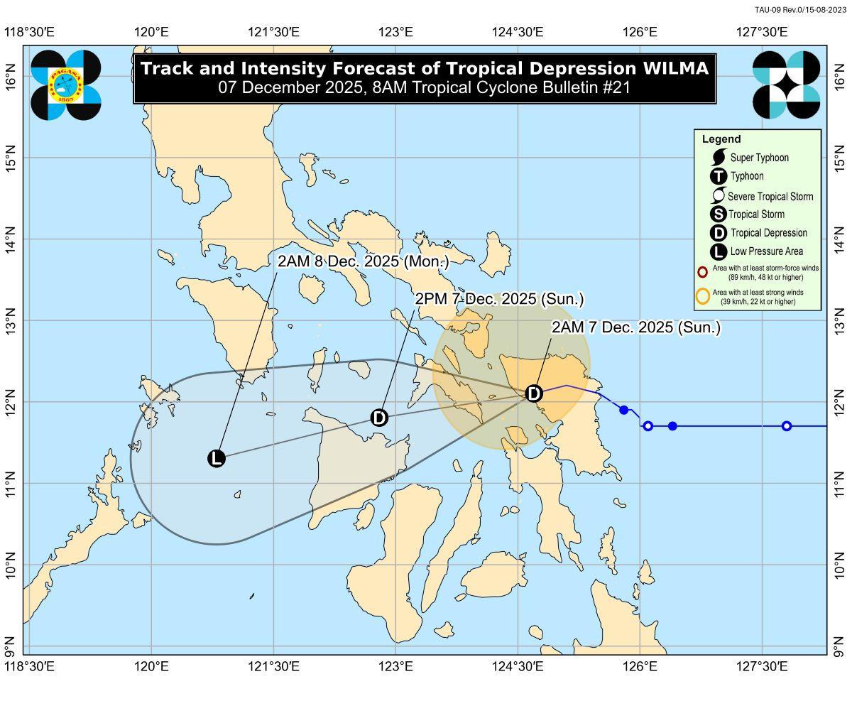
Latest available data showed that the center of Wilma was estimated to be located over the coastal waters of Almagro, Samar, it added.
Wilma is moving west northwestward at 15 km/h, packing maximum sustained winds of 45 km/h near the center and gustiness of up to 60 k/h.
Rainfall
Oriental Mindoro, Romblon, Aklan, Capiz, and Antique will have 50-100 mm of rainfall on Sunday, PAGASA said in its heavy rainfall outlook.
Meanwhile, a shear line will cause heavy rains of up to 100-200 mm on Sunday over Quezon, and 50-100 mm over Laguna, Batangas, Marinduque, Camarines Norte, Camarines Sur, Catanduanes, and Albay.
Winds
PAGASA said the Northeast Monsoon (Amihan) will bring strong to gale-force gusts over most of Luzon, Visayas, and Zamboanga Peninsula, especially in coastal and upland areas exposed to winds:
Gale warning, coastal waters
A gale warning was raised on Sunday over the northern and eastern seaboards of Luzon.
The seas will be up to very rough over:
- Up to 5.0 m: The seaboards of mainland Cagayan, Isabela, and Aurora; the northern and eastern seaboards of Polillo Islands, and Camarines Norte.
- Up to 4.5 m: The eastern seaboards of Batanes and Babuyan Islands, and northern mainland Quezon; the northern and eastern seaboards of Catanduanes; the northern seaboard of Camarines Sur.
"Sea travel is risky for all types or tonnage of vessels. All mariners must remain in port or, if underway, seek shelter or safe harbor as soon as possible until winds and waves subside," PAGASA said.
Coastal waters will be up to rough over:
- Up to 4.0 m: The remaining seaboards of Batanes and Babuyan Islands; the seaboards of Ilocos Norte.
- Up to 3.5 m: The eastern seaboards of Albay, and Sorsogon; the seaboard of Northern Samar.
- Up to 3.0 m: The seaboards of Ilocos Sur, La Union, and Kalayaan Islands; the western seaboard of Pangasinan; the eastern seaboard of Eastern Samar
"Mariners of small seacrafts, including all types of motorbancas, are advised not to venture out to sea under these conditions, especially if inexperienced of operating ill-equipped vessels," PAGASA said.
Meanwhile, coastal waters will be up to moderate to rough over:
- Up to 2.5 m: The remaining seaboards of Pangansinan; the seaboard of Cagayancillo Islands; the eastern seaboards of Dinagat Islands, Surigao del Sur, and Davao Oriental.
- Up to 2.0 m: The western seaboards of Bataan, Batangas, Lubang Islands, Palawan, and Antique; the remaining seaboards of Quezon and Camarines Sur; the seaboards of Zambales, Romblon, Marinduque, and Cuyo Islands; the southern seaboards of Occidental Mindoro and Oriental Mindoro; the northwestern seaboard of Masbate including Burias Islands; the northern seaboard of Zamboanga del Norte.
"Mariners of motorbancas and similarly sized vessels are advised to take precautionary measures while venturing out to sea and, if possible, avoid navigation under these conditions," the weather bureau said.
Track, intensity outlook
"It must be emphasized that heavy rainfall and severe winds may still be experienced in localities outside the landfall point and the forecast confidence cone," PAGASA said.
"Furthermore, the track may still shift within the limit of the forecast confidence cone," it added.
Wilma is expected to traverse Southern Luzon and Visayas on Sunday before emerging over Sulu Sea, where it may weaken into a low pressure area.
"However, the increasingly unfavorable environment caused by the surge of the Northeast monsoon increases the possibility of an earlier weakening into a low pressure area," PAGASA said.
The weather bureau advised the public to listen to PAGASA's bulletins on Wilma every six hours.
The next weather bulletin will be issued by PAGASA at 11 a.m.
Effects
The number of families affected by Wilma reached almost 30,000 and over 3,000 families were evacuated, the Office of Civil Defense (OCD) in Region 8 said Sunday.
Some areas in Eastern Samar, Legazpi City in Albay and Garchitorena in Camarines Sur got flooded after rains brought by Wilma. —KG, GMA Integrated News
