

LPA east of Davao City now Tropical Depression Ada —PAGASA
The low pressure area inside the Philippine Area of Responsibility has intensified into a tropical depression and called Ada, according to state weather bureau PAGASA
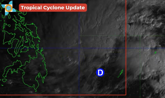
PAGASA said as of 8 a.m., January 14, the LPA located east of Davao City developed into a tropical depression. It is packing maximum sustained winds of 45 km per hour near the center and gustiness of up to 55 km per hour.
It is moving nortwestward at 35 km per hour.
Ada is expected to affect Bicol Region, Eastern Visayas, and eastern portions of Central and Northern Luzon.
In a Super Radyo dzBB interview, PAGASA weather specialist John Manalo said TD Ada may further intensify in the coming days as it remains over open waters.
“Possible na mas lumakas pa by Friday and Saturday, pinakamalapit sa atin,” he said.
(It is possible that it may further intensify by Friday and Saturday, when it is closest to the country.)
Two possible scenarios are being monitored, including the chance that Ada may not make landfall, though authorities are not ruling out that possibility.
“May dalawa tayong scenario, hopefully hindi mag-landfall pero hindi natin inaalis ang posibilidad na ’yan. So yung northward na direction, kapag malapit pa rin siya at nananatili sa coastal areas natin, yung mga probinsya sa Aurora, Cagayan Valley Region ay maaapektuhan din po," Manalo said.
(We have two scenarios. Hopefully, it will not make a landfall, but we are not removing that possibility. If it moves northward and remains close to our coastal areas, provinces such as Aurora and the Cagayan Valley Region may also be affected.)
Residents in disaster-prone and coastal areas, particularly in the Bicol Region, were advised to closely monitor weather updates and follow instructions from local authorities, including possible evacuation orders
Meanwhile, PAGASA said the likelihood of significant impact on Cebu and nearby areas remains low due to prevailing atmospheric conditions.
“May posibilidad po pero lumiliit naman na po 'yung posibilidad kasi 'yung range o 'yung extension ng high pressure area ay pumipigil para mag-west ito papunta ng West Philippine Sea. Nakikita din natin na mas favorable na hindi na ito mag-landfall at pag ganoon po ang mangyari ay mababawasan yung epekto na posibleng maramdaman sa Mactan," he noted.
(There is still a possibility, but it is decreasing because the extension of the high-pressure area is preventing it from moving westward toward the West Philippine Sea. We also see that it is more favorable for it not to make landfall, which would reduce possible effects in Mactan.)
As for Metro Manila, PAGASA said minimal weather disturbances are expected.
PAGASA urged the public to stay alert and regularly monitor official weather bulletins as the situation continues to develop.—AOL, GMA Integrated News
