

Ada slightly intensifies; Signal No. 1 raised over 11 areas
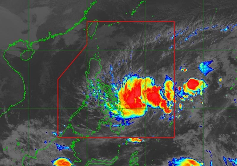
Tropical Depression Ada slightly intensified while moving over the Philippine Sea east of Mindanao as 11 areas remain under Signal No. 1 on Thursday morning, according to the latest Tropical Cyclone Bulletin posted by PAGASA.
The center of Tropical Depression Ada was estimated at 385 kilometers east northeast of Hinatuan, Surigao del Sur or 465 km East of Surigao City, Surigao del Norte packing maximum sustained winds of 55 kilometers per hour near the center, gustiness of up to 70 km/h, and central pressure of 1000 hPa.
Ada is moving northwestward at the speed of 20 km/h with strong winds extend outwards up to 400 km from the center.
Tropical Cyclone Wind Signal (TCWS) Signal No.1 is hoisted over the following areas:
Luzon
- Sorsogon
- the southeastern portion of Albay (Rapu-Rapu, Manito, Legazpi City)
Visayas
- Northern Samar
- Samar
- Eastern Samar
- the eastern portion of Biliran (Maripipi, Kawayan, Culaba, Caibiran, Cabucgayan)
- the eastern portion of Leyte (Carigara, Barugo, San Miguel, Babatngon, Tacloban City, Tunga, Jaro, Alangalang, Santa Fe, Palo, Dagami, Pastrana, Tanauan, Tabontabon, Julita, Dulag, Tolosa, La Paz, Mayorga, Macarthur, Javier, Abuyog, Mahaplag)
- the eastern portion of Southern Leyte (Silago, Sogod, Libagon, Saint Bernard, Hinunangan, Hinundayan, Anahawan, San Juan, Liloan, San Ricardo, San Francisco, Pintuyan)
Mindanao
- Dinagat Islands
- Surigao del Norte
- Surigao del Sur
Heavy Rainfall Outlook
The forecast rainfall over Northern Samar, Eastern Samar, Leyte, Southern Leyte, Dinagat islands, Surigao del Norte and Surigao del Sur is between 50 to 100 mm.
Severe Winds
"The wind signals warn the public of the general wind threat over an area due to the tropical cyclone. Local winds may be slightly stronger/enhanced in coastal and upland/mountainous areas exposed to winds. Winds are less strong in areas sheltered from the prevailing wind direction," PAGASA reported.
The Northeast Monsoon and the periphery of ADA will also bring strong to gale-force gusts over the following areas (especially in coastal and upland areas exposed to winds): Batanes, Babuyan Islands, Ilocos Norte, northern and eastern mainland Cagayan, eastern Isabela, Aurora, most of CALABARZON, Lubang Islands, Marinduque, Romblon, Oriental Mindoro, Cuyo Islands, Bicol Region, and Central Visayas
Hazards affecting coastal waters
Up to rough seas over the following coastal waters
Up to 4.0 m: The northern and eastern seaboards of Catanduanes, Northern Samar, and Siargao-Bucas Grande Islands; the eastern seaboards of Eastern Samar, and Dinagat Islands.
Up to 3.5 m: The seaboards of Isabela, Aurora, northern mainland Quezon, and Camarines Norte; the northern seaboard of Camarines Sur; the eastern seaboards of Albay, Sorsogon, and Surigao del Sur.
Up to 3.0 m: The seaboards of Batanes, Cagayan, and Ilocos Norte; the eastern seaboard of Davao Oriental
Mariners of small seacrafts, including all types of motorbancas, are advised not to venture out to sea under these conditions, especially if inexperienced or operating ill-equipped vessels.
Up to moderate seas over the following coastal waters
Up to 2.5 m: The eastern seaboard of Camarines Sur; the remaining seaboard of Catanduanes.
Up to 2.0 m: The eastern seaboard of Davao Occidental; the remaining seaboards of Ilocos Region.
Mariners of motorbancas and similarly sized vessels are advised to take precautionary measures while venturing out to sea and, if possible, avoid navigation under these conditions.
Elsewhere, coastal waters will have wave heights of less than 2.0 meters.
Track and Intensity Outlook
PAGASA said that Tropical Depression Ada will generally move northwestward today through Sunday (18 January) before turning north northeastward by Monday (19 January).
On the forecast track, ADA may pass close to Eastern Samar and Northern Samar on Friday (16 January) or Saturday (17 January) early morning before heading towards Catanduanes, where it is likely to make a close approach to Catanduanes on Sunday morning.
A further westward shift in the forecast track may result in a possible landfall over Eastern Visayas and Bicol Region.
"Ada is forecast to reach tropical storm category today and will continue to gradually intensify while moving over the Philippine Sea," according to the state weather bureau. — BAP, GMA Integrated News
