

Ada moves north northwestward; Signal No. 1 remains over 15 areas
Tropical Storm Ada continues to move slowly north northwestward while over the Philippine Sea east of Eastern Visayas while 15 areas remain under Signal No. 1, according to the latest Tropical Cyclone Bulletin posted by PAGASA.
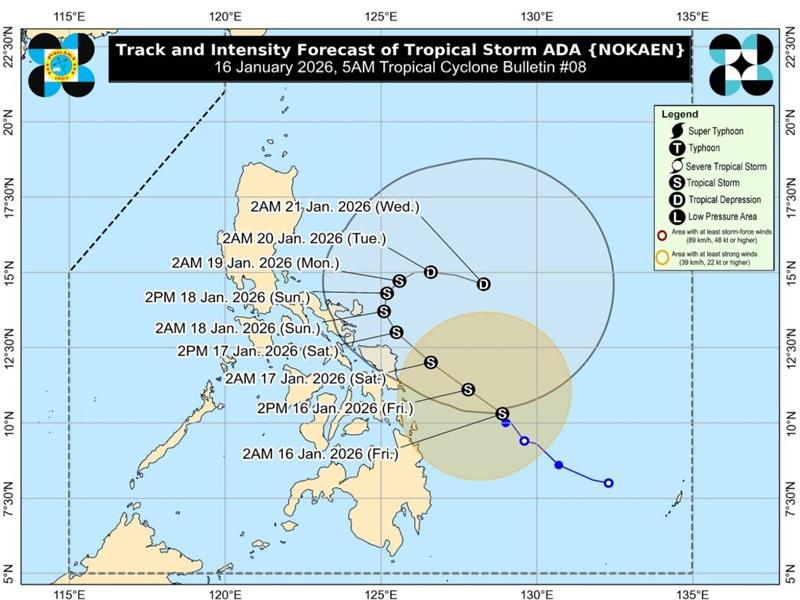
The center of Tropical Storm Ada was estimated at 370 kilometers East of Surigao City, Surigao del Norte or 430 km East of Maasin City, Southern Leyte packing maximum sustained winds of 65 kilometers per hour near the center, gustiness of up to 80 km/h, and central pressure of 998 hPa.
Ada is moving north northwestward slowly with strong to gale-force winds extend outwards up to 400 km from the center.
Tropical Cyclone Wind Signal (TCWS) No. 1 is in effect over the following areas:
Luzon
- The eastern portion of Camarines Norte (Mercedes, Basud, San Lorenzo Ruiz, San Vicente, Daet, Talisay, Vinzons)
- Camarines Sur
- Catanduanes
- Albay
- Sorsogon
- the eastern portion of mainland Masbate (Pio V. Corpuz, Cataingan, Palanas, Dimasalang, Uson, Mobo, City of Masbate, Baleno, Aroroy) including Ticao and Burias Islands
Visayas
- Northern Samar
- Samar
- Eastern Samar
- Biliran
- the northern and central portions of Leyte (Carigara, Barugo, San Miguel, Babatngon, Tacloban City, Tunga, Jaro, Alangalang, Santa Fe, Palo, Dagami, Pastrana, Tanauan, Tabontabon, Julita, Dulag, Tolosa, La Paz, Mayorga, Macarthur, Javier, Abuyog, Mahaplag, Kananga, Capoocan, Leyte, Calubian, San Isidro, Tabango, Burauen, Ormoc City, Matag-Ob, Villaba, Albuera, Palompon, Merida, Isabel, City of Baybay)
- the eastern portion of Southern Leyte (Silago, Sogod, Libagon, Saint Bernard, Hinunangan, Hinundayan, Anahawan, San Juan, Liloan, San Ricardo, San Francisco, Pintuyan)
Mindanao
- Dinagat Islands
- Surigao del Norte
- Surigao del Sur
Heavy Rainfall Outlook
Rainfall volume from 100 to 200 mm over Northern Samar and Eastern Samar and 50 to 100 mm over Catanduanes, Sorsogon, Samar, Biliran, Leyte, Southern Leyte, Dinagat Islands, Surigao del Norte, and Agusan del Norte
Severe Winds
The Northeast Monsoon and the periphery of ADA will also bring strong to gale-force gusts over the following areas (especially in coastal and upland areas exposed to winds): Batanes, Babuyan Islands, Ilocos Norte, eastern Isabela, Aurora, CALABARZON, Occidental Mindoro, Oriental Mindoro, Romblon, Marinduque, Cuyo Islands, Bicol Region, Visayas, and Caraga.
Hazards affecting coastal waters
Up to rough seas over the following coastal waters
Up to 4.0 m: The northern and eastern seaboards of Catanduanes and Northern Samar; the eastern seaboards of Albay, Sorsogon, and Eastern Samar; the northern seaboard of Camarines Sur; the seaboard of Camarines Norte.
Up to 3.5 m: The northern and eastern seaboards of Siargao-Bucas Grande and Polillo Islands; the eastern seaboards of Dinagat Islands and Surigao del Sur; the seaboard of Aurora and northern mainland Quezon.
Up to 3.0 m: The seaboard of Isabela; the eastern seaboards of mainland Cagayan and Babuyan Islands.
Mariners of small seacrafts, including all types of motorbancas, are advised not to venture out to sea under these conditions, especially if inexperienced or operating ill-equipped vessels.
Up to moderate seas over the following coastal waters
Up to 2.5 m: The seaboards of Batanes, Ilocos Norte, and Davao Oriental; the northern seaboard of mainland Cagayan; the eastern seaboard of Camarines Sur; the remaining seaboard of Catanduanes and Babuyan Islands.
Up to 2.0 m: The eastern seaboard of Davao Occidental.
Mariners of motorbancas and similarly sized vessels are advised to take precautionary measures while venturing out to sea and, if possible, avoid navigation under these conditions.
Other coastal waters have wave heights of less than 2.0 m
Track and Intensity Outlook
Tropical Storm Ada will move generally northwestward today through tomorrow (17 January) before turning slowly north northwestward to northeastward by Sunday (18 January).
"Beginning Tuesday (20 January) evening, ADA is forecast to move southeastward while moving over the sea east of Bicol Region," said PAGASA.
"On the forecast track, the center of ADA may pass close to Eastern Samar and Northern Samar tomorrow and Catanduanes by Sunday. A further westward shift in the forecast track may result in a possible landfall over Eastern Visayas and Bicol Region," PAGASA also said.
The track forecast may change for Saturday or Sunday. But Ada is forecast to remain a tropical storm category while moving over the sea east of Visayas and Southern Luzon and may weaken into a tropical depression by Tuesday. — BAP, GMA Integrated News
