

Signal No. 2 up over Catanduanes, part of Camarines Sur due to Ada
Tropical Cyclone Wind Signal (TCWS) No. 2 was raised over Catanduanes and the eastern portion of Camarines Sur, particularly Caramoan, on Sunday due to Tropical Storm Ada (international name: Nokaen), PAGASA said in its 5 a.m. bulletin.
These areas will have gale-force winds with speeds of 62 to 88 km/h in 24 hours which may pose minor to moderate threat to life and property.
TCWS No. 1 meanwhile, was hoisted over the following areas:
- the southeastern portion of Isabela (Dinapigue, Palanan);
- Aurora;
- the eastern portion of Quezon (Tagkawayan, Guinayangan, Lopez, Calauag, Buenavista, San Narciso, San Andres, San Francisco, Mulanay, Catanauan, General Luna, Macalelon, Gumaca, Pitogo, Unisan, Atimonan, Plaridel, Agdangan, Padre Burgos, Quezon, Alabat, Perez, General Nakar, Infanta, Real, Mauban) including Polillo Islands;
- Marinduque;
- the eastern portion of Romblon (Cajidiocan, Magdiwang, San Fernando);
- Camarines Norte;
- the rest of Camarines Sur;
- Albay;
- Sorsogon;
- the northern and central portions of Masbate (Uson, Mobo, City of Masbate, Baleno, Aroroy, Mandaon, Milagros, Balud) including Ticao and Burias Islands; and
- Northern Samar.
Areas under TCWS No. 1 may experience strong winds with speeds of 39 to 61 km/h in 36 hours, posing minimal to minor threat to life and property.
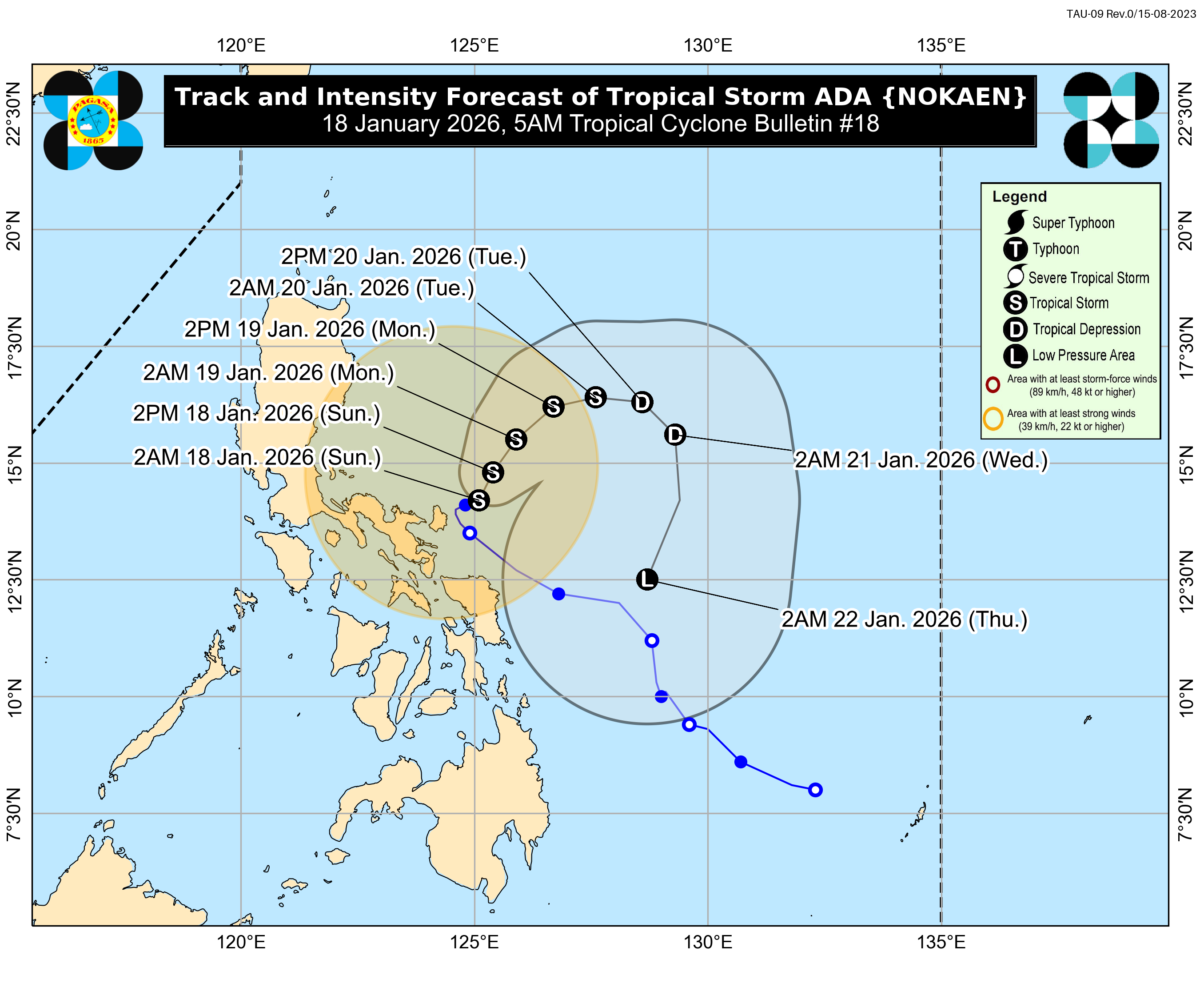
Ada slightly weakened on Sunday morning as it moved slowly over the waters east of Catanduanes, though weather officials warned of potential storm surges and hazardous sea conditions across the eastern seaboard of Luzon.
PAGASA reported that the center of the storm was located 135 km east northeast of Virac, Catanduanes, or 395 km east of Infanta, Quezon.
The storm currently packs maximum sustained winds of 75 km/h near the center and gustiness of up to 90 km/h.
PAGASA warned that heavy rainfall and severe winds may still be experienced even outside the storm’s forecast track and landfall point.Local winds may be stronger in coastal and mountainous areas exposed to prevailing winds, forecasters said.
Aside from the effects of Ada, the Northeast Monsoon (Amihan) and the storm’s outer circulation are expected to bring strong to gale-force gusts over several areas, which include Batanes, Ilocos Norte, Abra, Cagayan, Isabela, Quirino, Quezon, Romblon, Eastern Visayas, the Bicol Region, Aurora, and Northern Samar over the next three days.
PAGASA also warned of possible coastal flooding, with a minimal to moderate risk of storm surge reaching up to 2.0 meters within the next 24 hours in low-lying or exposed coastal communities of Camarines Norte, Camarines Sur, Catanduanes, Albay, and Sorsogon.
A gale warning remains in effect over the eastern seaboards of Southern Luzon, as very rough to rough seas continue to affect coastal waters.
Wave heights of up to 4.5 meters are expected along the northern seaboards of Camarines Norte and Camarines Sur and the northern and eastern seaboards of Catanduanes, making sea travel risky for all types of vessels. PAGASA advised all mariners to remain in port or seek safe harbor.
Rough seas of up to 4.0 meters may affect the eastern seaboards of Cagayan, Isabela, Aurora, and northern Quezon, including the Polillo Islands, while waves of up to 3.5 meters may occur along the eastern seaboard of the Babuyan Islands.
Moderate seas of up to 2.5 meters are expected over the eastern seaboard of Eastern Samar, while waves of up to 2.0 meters may affect Romblon, Marinduque, Kalayaan Islands, parts of Palawan, the Bicol Region, and Northern Samar.
PAGASA said Ada is expected to continue moving northeastward until Monday before following a looping track over the sea east of Luzon.
The storm is forecast to remain a tropical storm before weakening into a tropical depression by Tuesday and further weakening into a low-pressure area by Thursday due to the surge of the Northeast Monsoon. —MCG/KG, GMA Integrated News
