

2 areas under Signal No. 2 as Ada keeps strength, moves away from Catanduanes
Two areas in Luzon are under Storm Signal No. 2 as Tropical Storm Ada maintained its strength while slowly moving away from Catanduanes, PAGASA said Sunday.
In its 11 a.m. tropical cyclone bulletin, the state weather bureau said these areas are Catanduanes and the eastern portion of Camarines Sur (Caramoan).
Meanwhile, the following areas are under Signal No. 1:
Luzon
- The southern portion of Quezon (Tagkawayan, Guinayangan, Lopez, Calauag, Buenavista, San Narciso, San Andres, San Francisco, Mulanay, Catanauan, General Luna, Macalelon, Gumaca, Pitogo, Unisan, Atimonan, Plaridel, Agdangan, Padre Burgos, Quezon, Alabat, Perez) including Polillo Islands
- Camarines Norte
- The rest of Camarines Sur
- Albay
- Sorsogon
- Ticao
- Burias Islands
Visayas
- Northern Samar
“It must be emphasized that heavy rainfall and severe winds may still be experienced in localities outside the landfall point and the forecast confidence cone,” the state weather bureau said.
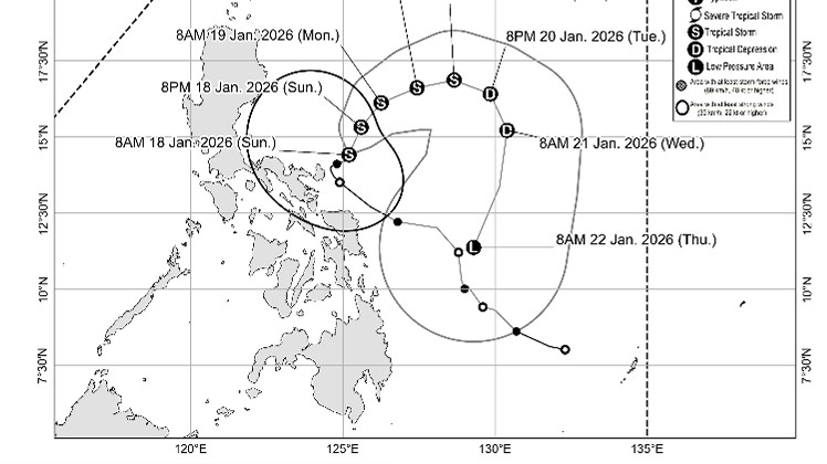
At 10 a.m., Ada was located 140 km Northeast of Virac, Catanduanes.
It is carrying maximum sustained winds of 75 km/h near the center, gustiness of up to 90 km/h, and is moving north northeastward slowly.
State meteorologists warned of a general wind signal threat due to the storm, but local winds may be slightly stronger or enhanced in coastal, upland, or mountainous areas.
Winds are less strong in areas sheltered from the prevailing wind direction.
Meanwhile, the Northeast Monsoon (Amihan) and the periphery of Adaon Sunday will bring strong to gale-force gusts over Batanes, Cagayan, Isabela, Quirino, Ilocos Norte, Aurora, Quezon, Bicol Region, Northern Samar, Samar, and Eastern Samar.
There is a minimal to moderate risk of storm surge with peak heights reaching up to 2.0 m within the next 24 hours over the low-lying or exposed coastal communities of Camarines Sur, Catanduanes, Albay, and Sorsogon.
A gale warning is also in effect over the eastern seaboard of Southern Luzon.
PAGASA said Ada is expected to move generally northeastward until Monday before following a looping track over the sea east of Luzon, but changes in the forecast track over the succeeding bulletins are possible.
“Ada is forecast to remain a tropical storm while moving over the sea east of Luzon. It is then forecast to weaken into a tropical depression by Tuesday (20 January) and further weaken into a low pressure area by Thursday (22 January) afternoon or evening due to the surge of the northeast monsoon. An earlier weakening remains possible,” PAGASA said. — Mariel Celine Serquiña/RF, GMA Integrated News
