

Signal No. 1 up over parts of Surigao as Basyang nears eastern Mindanao
Tropical Depression Basyang maintained its strength on Wednesday morning as it continued moving southwestward over the waters east of Mindanao, prompting Tropical Cyclone Wind Signal (TCWS) No. 1 over parts of Surigao del Sur and Surigao del Norte, state weather bureau PAGASA said.
TCWS No. 1 was raised over Surigao del Sur and the eastern portion of Surigao del Norte, including Claver, Gigaquit, and Bacuag, as well as the Siargao–Bucas Grande Islands, PAGASA said.
Under this signal, wind speeds of 39 to 61 kph may be experienced within the next 36 hours, posing minimal to minor threats to life and property.
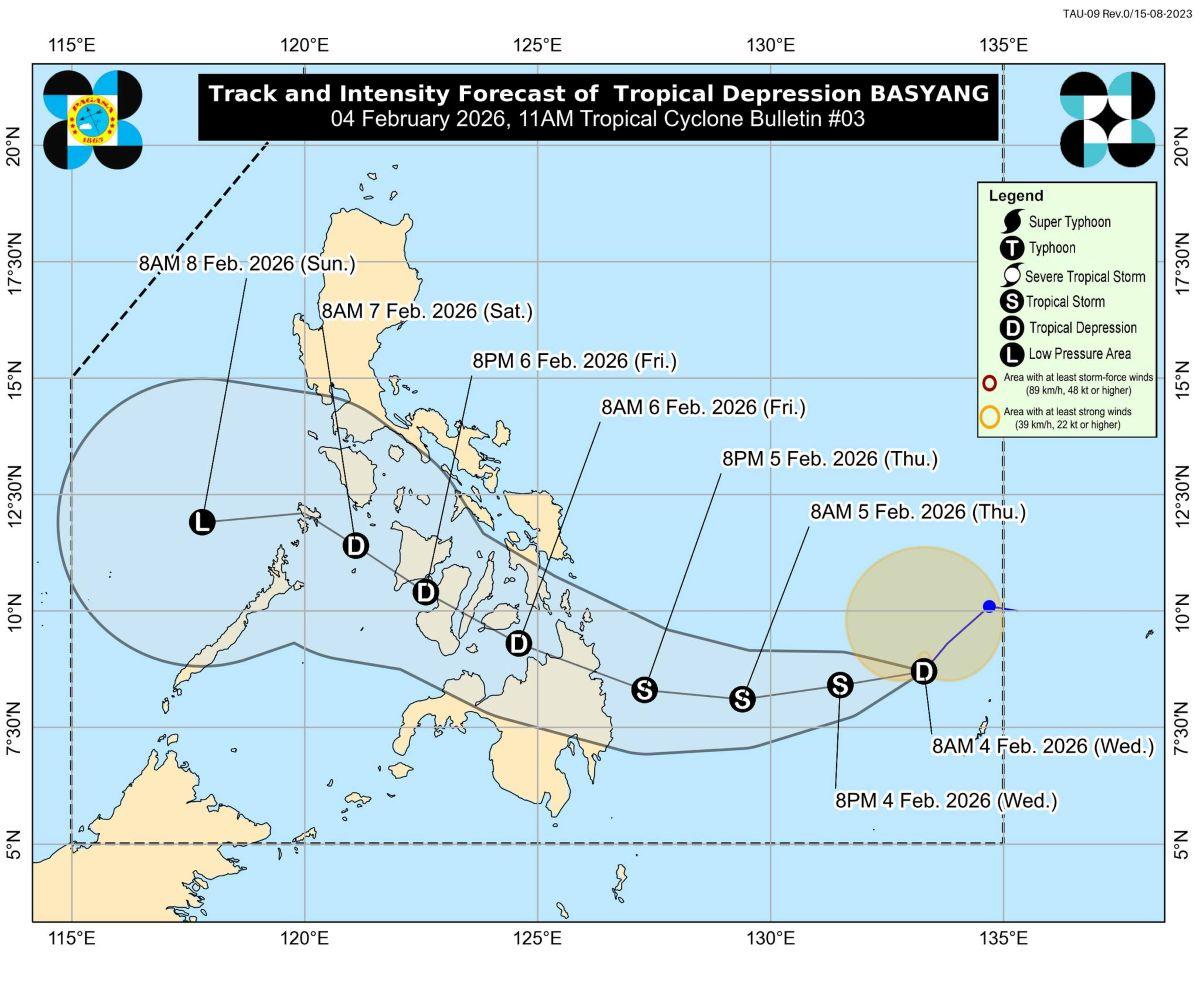
In its 11 a.m. Tropical Cyclone Bulletin No. 3, PAGASA said Basyang was last located at 10 a.m. in the Philippine Sea, about 735 kilometers east of Hinatuan, Surigao del Sur.
Basyang was packing maximum sustained winds of 55 kilometers per hour near the center, with gusts of up to 70 kph, and moving southwestward at 15 kph. Strong winds are extending outward up to 250 kilometers from the center.
PAGASA said TCWS No. 2 is the highest wind signal that may be hoisted during the passage of Basyang.
Apart from the tropical cyclone, the enhanced Northeast Monsoon (Amihan) is expected to bring strong to gale-force gusts over large parts of the country.
On Wednesday, these conditions may affect most of Luzon and the Visayas, as well as Dinagat Islands, Caraga, Davao Region, Zamboanga Peninsula, Camiguin, Misamis Oriental, and Lanao del Norte.
Similar conditions are forecast to persist through Friday, expanding to include Metro Manila, CALABARZON, MIMAROPA, Bicol Region, and most of Mindanao.
Rainfall
Dinagat Islands, Surigao del Norte, Surigao del Sur, and Davao Oriental may expect heavy rainfall measuring 50 to 10 mm on Wednesday until Thursday noon, PAGASA said in its rainfall outlook.
Heavy rainfall of 100 to 200 mm are forecast from Thursday noon to Friday noon over Southern Leyte, Bohol, Dinagat Islands, Surigao del Norte, Surigao del Sur, Agusan del Norte, Agusan del Sur, Camiguin, and Misamis Oriental.
Meanwhile, 50 to 100 mm of rainfall may be expected in Eastern Samar, Samar, Leyte, Cebu, Negros Oriental, Siquijor, Misamis Occidental, Lanao del Norte, Lanao del Sur, Bukidnon, Davao del Norte, Davao de Oro, and Davao Oriental starting Thursday noon to Friday noon.
From Friday noon to Saturday noon, Aklan and Antique may have 100 to 200 mm of rainfall, while Palawan, Oriental Mindoro, Romblon, Capiz, Iloilo, Guimaras, and Negros Occidental may have 50-100 mm of rainfall.
Coastal waters
PAGASA also warned of hazardous sea conditions, particularly along the eastern seaboard of the Visayas, where a gale warning is in effect.
Sea waves may reach up to 5.0 meters along the seaboard of Surigao del Sur and the Siargao–Bucas Grande Islands, and up to 4.5 meters in parts of Eastern Samar, Northern Samar, Dinagat Islands, and northern Davao Oriental.
“Sea travel is risky for all types or tonnage of vessels,” PAGASA said, advising all mariners to remain in port or seek shelter until winds and waves subside.
Operators of small seacrafts, including motorbancas, were also urged not to venture out to sea in areas experiencing rough to very rough conditions.
Track
On its forecast track, Basyang is expected to move generally westward for the next 36 hours before turning west-northwestward by Wednesday evening.
PAGASA said the cyclone may make its initial landfall over eastern Mindanao between Thursday evening and Friday morning, before crossing northeastern Mindanao and the Visayas, and emerging over the Sulu Sea by Saturday morning.
Basyang may intensify into a tropical storm while over the Philippine Sea on Wednesday.
However, it is forecast to weaken back into a tropical depression after landfall and eventually downgrade into a low pressure area by Sunday.
PAGASA reminded the public and local disaster risk reduction offices to take necessary precautions, especially in areas prone to flooding, landslides, and strong winds, and to continue monitoring official weather bulletins and advisories.
Classes
Classes have been suspended in some areas on Wednesday, February 4, 2026, due to Basyang. —KG, GMA Integrated News
