

11 areas under Signal No. 1 as Basyang moves closer to PH
Signal No. 1 was hoisted in more areas in Visayas and Mindanao as Tropical Depression Basyang moves westward over the Philippine Sea east of Mindanao, PAGASA said late Wednesday afternoon.
According to its 5 p.m. weather bulletin, the state weather bureau said the following areas are under Signal No. 1
Visayas- The southern portion of Eastern Samar (Guiuan, Salcedo, Mercedes, Giporlos, Balangiga, Lawaan, Quinapondan, General Macarthur, Hernani, Llorente, Maydolong, Balangkayan, City of Borongan)
- The southern portion of Samar (Marabut, Basey)
- Southern Leyte
- The central and southern portions of Leyte (Matalom, Bato, Hilongos, Hindang, Inopacan, Mahaplag, Abuyog, Macarthur, Javier, City of Baybay, Tolosa, Palo, Tacloban City, Santa Fe, Pastrana, Dagami, Albuera, Tabontabon, Tanauan, Dulag, Julita, La Paz, Mayorga, Burauen)
Mindanao
- Dinagat Islands
- Surigao del Norte
- Surigao del Sur
- Agusan del Norte
- Agusan del Sur
- Camiguin
- The eastern portion of Misamis Oriental (Talisayan, Medina, Magsaysay, Gingoog City, Balingoan, Kinoguitan, Claveria, Sugbongcogon, Salay, Binuangan, Lagonglong, Balingasag), and the northern portion of Davao Oriental (Boston, Cateel)
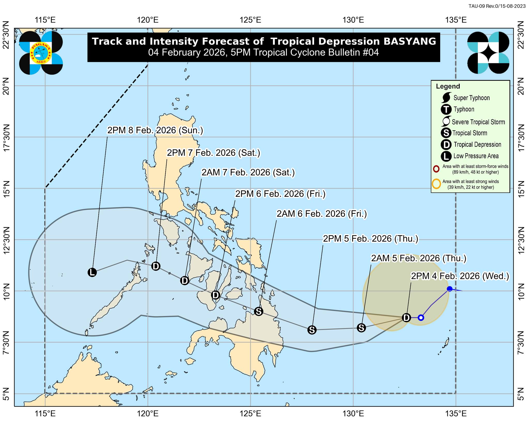
Basyang was located 655 km east of Hinatuan, Surigao del Sur. It is carrying maximum sustained winds of 55 km/h near the center, gustiness of up to 70 km/h, and is moving westward at 15 km/h.
PAGASA said minimal to minor impacts from strong winds are possible within any of the areas under Wind Signal No. 1.
Meanwhile, the highest wind signal expected during Basyang’s passage is Wind Signal No. 2.
“It must be emphasized that heavy rainfall and severe winds may still be experienced in localities outside the landfall point and the forecast confidence cone,” state meteorologists said.
Meanwhile, the surge of the Northeast Monsoon (Amihan) will bring strong to gale-force gusts over Metro Manila, Apayao, Abra, Batanes, Babuyan Islands, the northern portion of mainland Cagayan, Central Luzon, Most of Southern Luzon, Visayas, and most of Mindanao on Thursday.
There is a minimal to moderate risk of storm surge, with peak heights of up to 2.0 m expected within the next 48 hours in the low-lying or exposed coastal areas of Dinagat Islands, Surigao del Norte, Surigao del Sur, and Davao Oriental.
A gale warning is also in effect over the eastern seaboards of Visayas and Mindanao.
BASYANG is seen to move generally westward for the next 36 hours before turning west northwestward beginning Thursday evening.
“The center of Basyang will make its initial landfall over eastern Mindanao between Thursday evening and early Friday morning. Afterwards, it will traverse the landmass of northeastern Mindanao and Central and Western Visayas and emerge over Sulu Sea by Saturday morning,” PAGASA said.
By Saturday afternoon or evening, Basyang is expected to cross the northern portion of Palawan, then re-emerge over the West Philippine Sea.
“Basyang is forecast to gradually intensify while over the Philippine Sea and may reach tropical storm category today,” PAGASA said.
“After its initial landfall, it will weaken into a tropical depression while traversing Visayas and will be downgraded to low pressure area by Sunday,” it added. —Mariel Celine Serquiña/RF, GMA Integrated News
