

Basyang maintains strength, now over Agusan Del Norte
Tropical Storm Basyang maintains its strength while traversing Agusan del Norte with Signal No. 2 raised over 16 areas, according to the Tropical Cyclone Bulleting posted by PAGASA.
The center of Tropical Storm Basyang was estimated to be in the vicinity of Jabonga, Agusan del Norte with maximum sustained winds of 65 kilometers per hour near the center, gustiness of up to 90 km/h, and central pressure of 1000 hPa.
Basyang is moving West northwestward at the speed of 25 km/h with strong to gale-force winds extend outwards up to 330 km from the center.
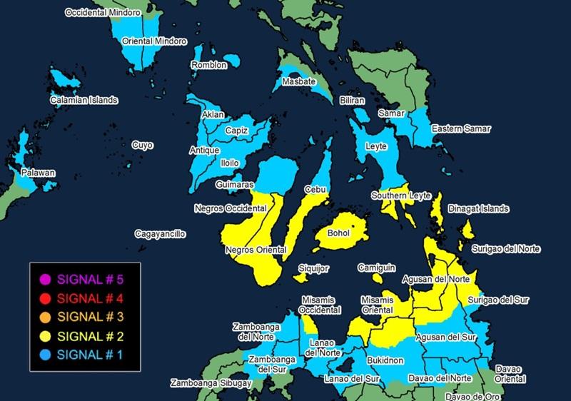
Tropical Cyclone Wind Signal (TCWS) No. 2 is hoisted over the following areas:
Visayas
the southern portion of Leyte (Matalom, Bato, Hilongos, Hindang)
Southern Leyte
Bohol
the central and southern portions of Cebu (Samboan, Malabuyoc, Oslob, Ginatilan, Alegria, Dalaguete, Boljoon, Alcoy, Santander, Argao, Badian, Moalboal, Ronda, Alcantara, Sibonga, Dumanjug, City of Carcar, Barili, Aloguinsan, San Fernando, Pinamungahan, City of Naga, Lapu-Lapu City, Cordova, Cebu City, City of Talisay, Minglanilla, Toledo City, Mandaue City, Consolacion, Liloan)
Siquijor
Negros Oriental
the southern portion of Negros Occidental (Candoni, City of Sipalay, Ilog, City of Kabankalan, Cauayan, Hinoba-An, City of Himamaylan, Binalbagan, Isabela, Moises Padilla, La Castellana, Valladolid, Pulupandan, La Carlota City, San Enrique, Pontevedra, Hinigaran)
Mindanao
Dinagat Islands
Surigao del Norte
the northern portion of Surigao del Sur (Lanuza, San Miguel, Tago, Carmen, Cortes, City of Tandag, Madrid, Cantilan, Carrascal)
Agusan del Norte
the northern portion of Agusan del Sur (City of Bayugan, Sibagat, Esperanza)
Camiguin
Misamis Oriental
the northern portion of Bukidnon (Impasug-Ong, Manolo Fortich, Malitbog, Sumilao, Libona, Baungon)
the eastern portion of Misamis Occidental (Baliangao, Plaridel, Lopez Jaena, Oroquieta City, Calamba, Aloran, Panaon)
TCWS No. 1 is raised over the following areas:
Luzon
the southern portion of Occidental Mindoro (San Jose, Magsaysay, Rizal, Calintaan, Sablayan)
the southern portion of Oriental Mindoro (Mansalay, Bulalacao, Gloria, Pinamalayan, Bansud, Bongabong, Roxas)
Romblon
the northern portion of Palawan (Taytay, El Nido, Dumaran, Araceli) including Calamian, Cuyo, and Cagayancillo Islands
the southern portion of Masbate (Mandaon, Milagros, Balud, Placer, Cawayan, Esperanza)
Visayas
the southern portion of Eastern Samar (Guiuan, Salcedo, Mercedes, Giporlos, Balangiga, Lawaan, Quinapondan, General Macarthur, Hernani, Llorente, Balangkayan, City of Borongan, Maydolong)
the southern portion of Samar (Marabut, Basey, Santa Rita, Daram, Talalora, Zumarraga, Villareal, Pinabacdao, Calbiga)
Biliran
the rest of Leyte
the rest of Cebu
the rest of Negros Occidental
Guimaras
Iloilo
Capiz
Aklan
Antique
Mindanao
the rest of Surigao del Sur
the rest of Agusan del Sur
the northern portion of Davao Oriental (Boston)
the northern portion of Davao de Oro (Monkayo, Montevista, Laak)
the northern portion of Davao del Norte (San Isidro, Talaingod, Kapalong)
the central portion of Bukidnon (San Fernando, Lantapan, City of Valencia, Talakag, Don Carlos, Maramag, Quezon, Kalilangan, Pangantucan, Cabanglasan, City of Malaybalay)
Lanao del Norte
the rest of Misamis Occidental
Lanao del Sur
the eastern and central portions of Zamboanga del Norte (Mutia, Piñan, Polanco, Dipolog City, Dapitan City, Sibutad, Rizal, La Libertad, Salug, Bacungan, Sindangan, Jose Dalman, Manukan, Pres. Manuel A. Roxas, Katipunan, Sergio Osmeña Sr., Siayan, Godod)
the northern and central portions of Zamboanga del Sur (Bayog, Kumalarang, Pagadian City, Tigbao, Lakewood, Dumingag, Mahayag, Molave, Josefina, Tambulig, Aurora, Ramon Magsaysay, Sominot, Midsalip, Labangan, Tukuran)
the northeastern portion of Zamboanga Sibugay (Kabasalan, Diplahan, Buug, Siay)
Heavy Rainfall Outlook
Heavy rainfall outlook due to Tropical Cyclone Basyang:
More than 200 mm: Cebu, Negros Oriental, Bohol, Siquijor, Surigao del Norte, Dinagat Islands, Agusan del Norte, Misamis Oriental, and Camiguin
100-200 mm: Palawan, Negros Occidental, Southern Leyte, Leyte, Antique, Iloilo, Guimaras, Agusan del Sur, Surigao del Sur, Misamis Occidental, Lanao del Norte, Lanao del Sur, Bukidnon, Davao del Norte, Davao de Oro, Davao Oriental, and Zamboanga del Norte
50-100 mm: Eastern Samar, Aklan, Capiz, Zamboanga del Sur, Zamboanga Sibugay, Maguindanao del Norte, Cotabato, and Davao del Sur
Severe Winds
The surge of the Northeast Monsoon will also bring strong to gale-force gusts over the following areas (especially in coastal and upland areas exposed to winds):
Batanes, Babuyan Islands, northern portion of mainland Cagayan, Metro Manila, CALABARZON, Bicol Region, most of MIMAROPA, Visayas, Dinagat Islands, Siargao and Bucas Grande Islands, Surigao del Norte, Surigao del Sur, Agusan Del Norte, Misamis Oriental, Lanao Del Norte, Lanao del Sur, Bukidnon, Misamis Occidental, Zamboanga Peninsula, Sarangani, Davao de Oro, Davao del Norte, and Davao Oriental.
Coastal Flooding
"There is a minimal to moderate risk of storm surge with peak heights reaching up to 2.0 m within the next 48 hours over the low-lying or exposed coastal communities of Occidental Mindoro. Oriental Mindoro, Romblon, Palawan including Calamian and Cuyo islands, Antique, Aklan, Capiz, Iloilo, Guimaras, Negros Occidental, Negros Oriental, Siquijor, Cebu, Bohol, Southern Leyte, Leyte, Camiguin, Dinagat Islands, Surigao del Norte, Surigao del Sur, Agusan del Norte, Misamis Oriental, Lanao del Norte, Misamis Occidental, and Davao Oriental," PAGASA reported.
Hazards affecting coastal waters
A Gale Warning is in effect over the eastern and central seaboards of Visayas and the northern and eastern seaboards of Mindanao.
The weather bureau warned that sea travel is risky and that all mariners must remain in port or, if underway, seek shelter or safe harbor as soon as possible until winds and waves subside.
Track and Intensity Outlook
Basyang will move generally west northwestward throughout the forecast period, PAGASA said.
The center of Basyang will continue to traverse Agusan del Norte, then will emerge over Bohol Sea this morning.
Between Friday morning and afternoon, Basyang may pass close or make another landfall over Bohol and southern portions of Cebu and Negros Oriental then emerge over Sulu Sea, pass close Cuyo Islands, and cross the northern portion of Palawan.
"Basyang will likely remain a tropical storm while traversing the Central and Western Visayas. Further weakening into a tropical depression is possible tonight or tomorrow morning and will be downgraded into a low pressure area by Sunday (08 February) morning," PAGASA added. — BAP, GMA Integrated News
