

Signal No. 1 still up over 32 areas as Basyang weakens into tropical depression
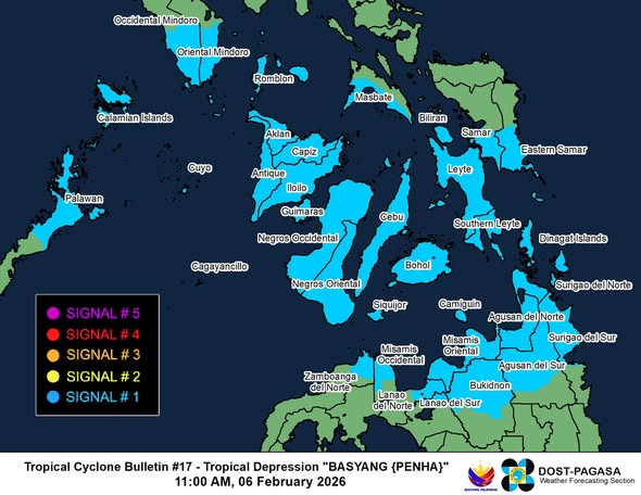
Tropical Cyclone Basyang has downgraded into a tropical depression on Friday morning but Tropical Cyclone Wind Signal No. 1 is still in effect over 32 areas across the country, state weather bureau PAGASA said.
In its 11 a.m. bulletin, PAGASA said the following areas are under Signal No. 1:
Luzon
- the southern portion of Occidental Mindoro (San Jose, Magsaysay, Rizal, Calintaan, Sablayan)
- the southern portion of Oriental Mindoro (Mansalay, Bulalacao, Gloria, Pinamalayan, Bansud, Bongabong, Roxas)
- Romblon
- the northern portion of Palawan (Taytay, El Nido, Dumaran, Araceli, Roxas, San Vicente) including Cuyo Islands, Cagayancillo Islands, and Calamian Islands
- and the southern portion of Masbate (Balud, Mandaon, Milagros, Esperanza, Placer, Cawayan)
Visayas
- the southern portion of Eastern Samar (Guiuan, Salcedo, Mercedes, Giporlos, Balangiga, Lawaan, Quinapondan, General Macarthur, Hernani, Llorente, Balangkayan, City of Borongan, Maydolong)
- the southern portion of Samar (Marabut, Basey, Santa Rita, Daram, Talalora, Zumarraga, Villareal, Pinabacdao, Calbiga)
- Guimaras
- Iloilo
- Capiz
- Antique
- Aklan
- Biliran
- Bohol
- Cebu
- Negros Occidental
- Negros Oriental
- Leyte
- Southern Leyte
- Siquijor
Mindanao
- Dinagat Islands
- Surigao del Norte including Siargao - Bucas Grande Islands
- Agusan del Norte
- Misamis Oriental
- Camiguin
- the northern portion of Surigao del Sur (Lianga, San Agustin, Marihatag, Cagwait, Bayabas, Cantilan, Carrascal, San Miguel, Tago, Cortes, City of Tandag, Lanuza, Carmen, Madrid, Barobo)
- the northern and central portion of Agusan del Sur (San Francisco, La Paz, Talacogon, San Luis, Prosperidad, Sibagat, City of Bayugan, Esperanza)
- the northern and central portions of Bukidnon (Lantapan, Talakag, Cabanglasan, City of Malaybalay, Libona, Manolo Fortich, Malitbog, Impasug-Ong, Sumilao, Baungon, City of Valencia)
- the eastern portion of Lanao del Norte (Iligan City, Pantar, Baloi, Tagoloan, Matungao, Linamon, Kauswagan, Pantao Ragat, Poona Piagapo)
- the northern portion of Misamis Occidental
- the northernmost portion of Lanao del Sur (Tagoloan II, Kapai, Saguiaran, Marawi City)
- and the eastern portion of Zamboanga del Norte (Rizal, Sibutad, La Libertad, Dapitan City, Dipolog City, Mutia, Piñan, Polanco, Katipunan)
Basyang was last spotted over the coastal waters of Anda, Bohol, packing maximum sustained winds of 55 kilometers per hour (kph) near the center and gustiness of up to 70 kph.
The tropical depression was moving west northwestward at 10 kph.
“On the forecast track, the center of BASYANG may pass close or make landfall over Bohol and southern portions of Cebu and Negros Oriental. Afterwards, it will pass close over the southern portion of Panay Island tomorrow afternoon or evening,” PAGASA said.
“BASYANG remains as a tropical depression while traversing the Central Visayas and Negros Island Region, it may weaken into a low pressure area tomorrow (07 February) afternoon or evening,” it added. —AOL, GMA Integrated News
