

Basyang moving towards Cebu, Negros Oriental; 28 areas under Signal No. 1
Tropical Depression Basyang continues to linger in the country, moving west northwest and is now over Cebu Strait.
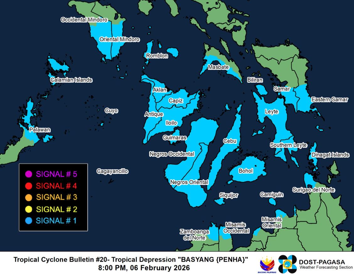
Signal No. 1 remains hoisted over 28 areas in Luzon, Visayas and Mindanao, according to PAGASA in its 8 p.m. cyclone bulletin.
On the forecast track, the center of Basyang may make another landfall over the southern portions of Cebu and Negros Oriental between Friday night and Saturday early morning before the tropical depression moves towards either Panay Island or over Panay Gulf.
Basyang was last seen over the coastal waters of Dalaguete, Cebu, with maximum sustained winds of 55 kilometers per hour and a gustiness of up to 75 kph.
The following areas under Signal no. 1 will experience winds of 39 kph to 61 kph to be expected within 36 hours:
Luzon
- The southern portion of Occidental Mindoro (San Jose, Magsaysay, Rizal, Calintaan, Sablayan)
- The southern portion of Oriental Mindoro (Mansalay, Bulalacao, Gloria, Pinamalayan, Bansud, Bongabong, Roxas)
- Romblon
- The northern portion of Palawan (Taytay, El Nido, Dumaran, Araceli, Roxax) including Cuyo Islands
- Cagayancillo Islands
- Calamian Islands
- The southern portion of Masbate (Balud, Mandaon, Milagros, Esperanza, Placer, Cawayan)
Visayas
- The southern portion of Eastern Samar (Guiuan, Salcedo, Mercedes, Giporlos, Balangiga, Lawaan, Quinapondan, General Macarthur, Hernani, Llorente, Balangkayan, City of Borongan, Maydolong)
- The southern portion of Samar (Marabut, Basey, Santa Rita, Daram, Talalora, Zumarraga, Villareal, Pinabacdao, Calbiga)
- Guimaras
- Iloilo
- Capiz
- Antique including Caluya Islands
- Aklan
- Biliran
- Bohol
- Cebu
- Negros Occidental
- Negros Oriental
- Leyte
- Southern Leyte
- Siquijor
Mindanao
- Dinagat Islands
- The western portion of Surigao del Norte (Mainit, Bacuag, Tagana-An, Tubod, Malimono, Placer, Alegria, San Francisco, Sison, Surigao City)
- The northern portion of Misamis Oriental (Laguindingan, Binuangan, Initao, Kinoguitan, Medina, Sugbongcogon, Talisayan, Balingoan, Gitagum, Lagonglong, Libertad, Salay, Magsaysay)
- The northern portion of Misamis Occidental (Plaridel, Baliangao, Calamba, Lopez Jaena, Sapang Dalaga, Aloran, Oroquieta City)
- Camiguin
- The northern portion of Zamboanga del Norte (Rizal, Sibutad, La Libertad, Dapitan City, Mutia, Piñan, Dipolog City, Polanco)
“Local winds may be slightly stronger/enhanced in coastal and upland/mountainous areas exposed to winds. Winds are less strong in areas sheltered from the prevailing wind direction,” PAGASA warned.
It noted that the surge of the Northeast Monsoon may cause strong to gale-force gusts in some areas, while strong winds and heavy rainfall may still be possible in areas outside the landfall point and forecast confidence cone.
It is predicted that Basyang will weaken into a low pressure area within 12 hours. —LDF, GMA Integrated News
