

 GMA Brandtalk
 Tracking
 Archives

Typhoon Domeng maintains strength while heading east of Batanes
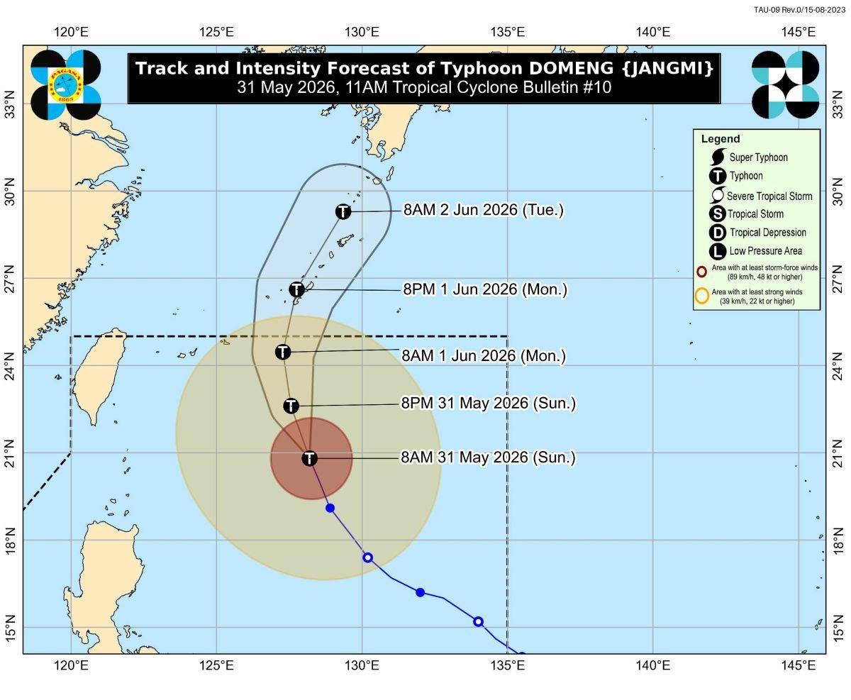
Typhoon Domeng (international name Jangmi) has maintained its strength while moving north northwestward over the Philippine Sea east of Batanes, PAGASA said Sunday morning.
According to the state weather bureau's 11 a.m. tropical cyclone bulletin, Domeng was located 645 km east of Basco, Batanes as of 10 a.m.
It is carrying maximum sustained winds of 120 km/h near the center, gustiness of up to 150 km/h, and is moving north northwestward at 15 km/h.
Hoisting of tropical cyclone wind signal over Extreme Northern Luzon is “less likely,” state meteorologists said.
Rainfall, winds, coastal waters
However, heavy rainfall and severe winds may still be experienced in localities outside the forecast confidence cone, they added.
According to PAGASA's weather advisory, Palawan, Occidental Mindoro, and Antique will have 50-100 mm of heavy rainfall on Sunday up to Monday noon.
Strong to gale-force gusts will be felt Sunday in the following areas due to the enhancement of the Southwest Monsoon (Habagat) and the periphery of Domeng: most of Visayas, Batanes, Cagayan, CALABARZON, MIMAROPA, Bicol Region, Zamboanga del Norte, Misamis Occidental, Misamis Oriental, Camiguin, Agusan del Norte, Dinagat Islands, Surigao del Norte, Sarangani, Davao Occidental, and Davao Oriental.
Mariners of small seacrafts, including all types of motorbancas, are advised not to venture out to sea, especially if inexperienced or using ill-equipped vessels, as waves may reach up to 3.5 m along the seaboard of Batanes and the eastern seaboards of Babuyan Islands and mainland Cagayan, and up to 3.0 m along the seaboard of Isabela and the northern seaboard of Babuyan Islands.
Waves may reach up to 2.5 meters along the remaining seaboards of Cagayan; the northern and eastern coasts of Polillo Islands and Catanduanes; the northeastern coast of Aurora; and the northern coast of Camarines Norte.
Up to 2.0 meter-tall waves are expected along the remaining coasts of Aurora; the northern coasts of Ilocos Norte and Camarines Sur; the northern and eastern coasts of Northern Samar; and the eastern coasts of southern Palawan, Sorsogon, Eastern Samar, Dinagat Islands, and Davao Oriental, as well as the southern coast of Kalayaan Islands.
Mariners of motorbancas and similarly sized vessels are advised to take precautions and avoid sailing if possible.
Track, intensity
Domeng is expected to continue moving north northwestward on Sunday before recurving towards southern Japan for the remaining forecast period.
PAGASA said the storm is less likely to make landfall over the country and will likely exit the Philippine Area of Responsibility Monday morning or afternoon.
“Domeng will continue to intensify until it reaches its peak intensity tomorrow (01 June) while remaining over the Philippine Sea. Afterwards, it will steadily weaken but will remain as a typhoon throughout the forecast period,” PAGASA said.
The weather bureau advised the public and disaster risk reduction and management offices concerned to take measures to protect life and property.
PAGASA said it will issue the next tropical cyclone bulletin at 5 p.m. —KG, GMA News

