

 GMA Brandtalk
 Tracking
 Archives

Typhoon Domeng slows down, reaches its peak intensity
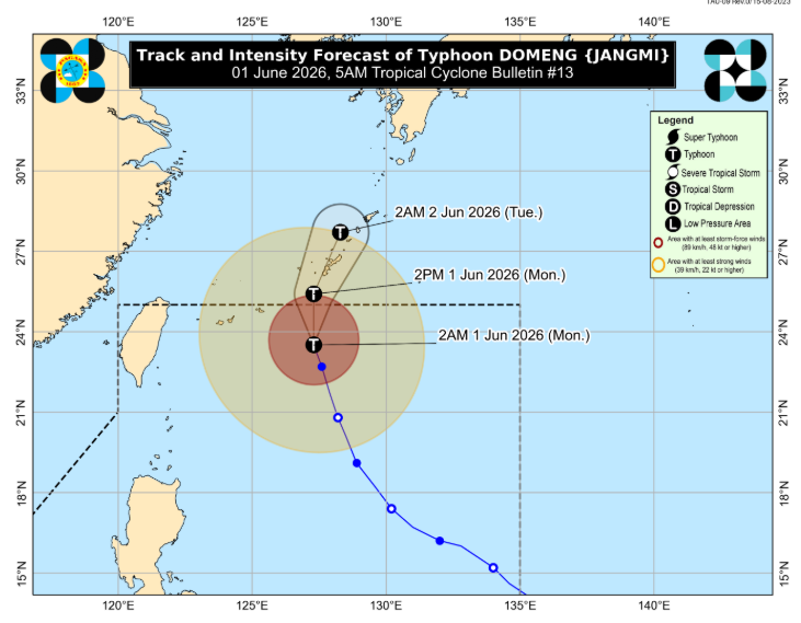
Typhoon Domeng slightly slowed down but maintained its strength on Monday morning, as the state weather bureau said it has likely reached its peak intensity.
In its 5 a.m. tropical cyclone bulletin, PAGASA said the center of the eye of Domeng was estimated to be 655 km east northeast of Itbayat, Batanes as of 4 a.m. of June 1, 2026.
It is moving north northwestward at 15 km/h with maximum sustained winds of 130 km/h near the center and gustiness of up to 160 km/h.
PAGASA said no tropical cyclone wind signals are in effect.
Domeng will begin moving northward starting on Monday morning before turning north northeastward towards southern Japan.
The state weather bureau said the typhoon “has likely reached its peak intensity and will maintain its strength while moving over Okinawa, Japan,” after which a “weakening trend is expected.”
“This tropical cyclone will likely exit the Philippine Area of Responsibility (PAR) this morning or afternoon,” it added.
By 2 p.m. of June 1, Domeng is forecast to be 760 km northeast of Itbayat, Batanes or outside the PAR. By 2 a.m. of June 2, the typhoon is forecast to be 1,010 km northeast of Extreme Northern Luzon, still outside the PAR.
Meanwhile, PAGASA said the enhancement of the Southwest Monsoon or Habagat and the periphery of Domeng will bring strong to gale-force gusts over the following areas, especially in coastal and upland areas exposed to winds:
- Batanes
- Babuyan Islands
- Metro Manila
- CALABARZON
- MIMAROPA
- Bicol Region
- Panay Island, and
- Negros Occidental
— JMA/KG, GMA News

