

 GMA Brandtalk
 Tracking
 Archives

Signal No. 1 up over parts of Cagayan, 7 other areas due to Tropical Depression Luis
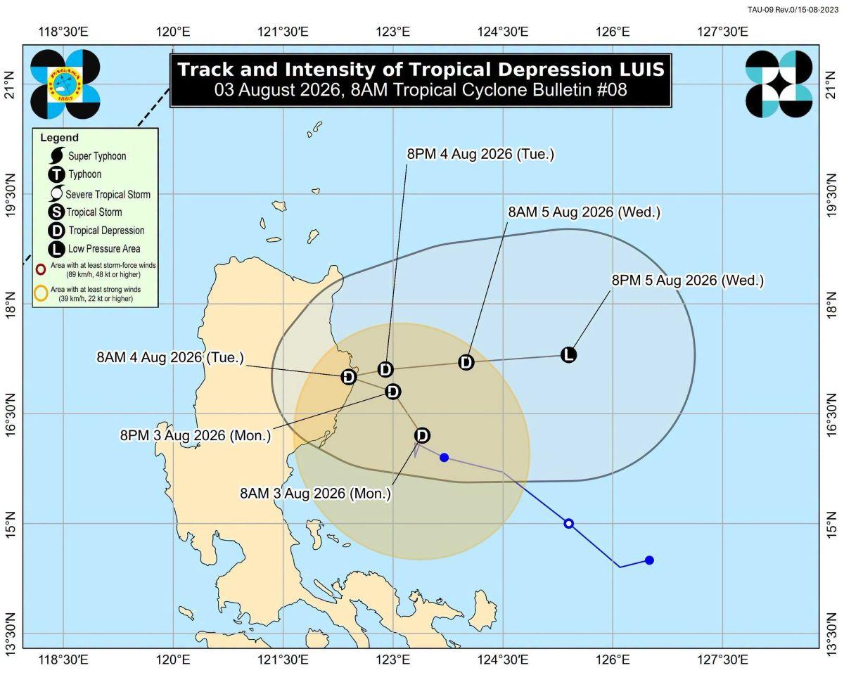
Parts of Cagayan and seven other areas in Luzon were placed under Tropical Cyclone Wind Signal No. 1 on Monday morning due to Tropical Depression Luis, PAGASA said.
TCWS No. 1 was raised over the following areas, according to PAGASA's 8 a.m. tropical cyclone bulletin:
- the central and eastern portions of Cagayan (Enrile, Tuguegarao City, Peñablanca, Piat, Santo Niño, Camalaniugan, Tuao, Lal-Lo, Gonzaga, Alcala, Amulung, Santa Teresita, Baggao, Buguey, Solana, Rizal, Santa Ana, Gattaran, Iguig, Lasam, Aparri, Ballesteros, Abulug, Allacapan, Pamplona);
- Isabela;
- Quirino;
- the eastern and southern portions of Apayao (Flora, Santa Marcela, Conner, Pudtol, Luna);
- the eastern portion of Kalinga (City of Tabuk, Tanudan, Pinukpuk, Rizal);
- the eastern portion of Mountain Province (Paracelis, Natonin);
- the eastern portion of Ifugao (Aguinaldo, Alfonso Lista); and
- the northern portion of Aurora (Dinalungan, Casiguran, Dilasag, Dipaculao, Baler)
These areas will experience strong winds with speeds of 39 to 61 km/h in 36 hours, posing minimal to minor threat to life and property.
At 7 a.m., Luis' center was estimated to be located at 135 km east of Casiguran, Aurora.
PAGASA said Luis maintained its strength, having maximum sustained winds of 55 km/h near the center, gustiness of up to 70 km/h, and central pressure of 1002 hPa.
Luis is moving northward slowly.
From its center, strong winds are extending outward up to 190 km.
PAGASA said Luis may make landfall or pass close to Northern Luzon on Monday night or early Tuesday morning.
Thereafter it will turn east northeastward while moving away from the Philippine landmass.
Rainfall
Luis will bring heavy rains measuring 100 to 200 mm today over La Union, Pangasinan, Zambales and Bataan.
Meanwhile, Benguet, Ifugao, Mountain Province, Kalinga, Nueva Vizcaya, Quirino, Tarlac, Nueva Ecija, Bulacan, and Pampanga will experience 50 to 100 mm of rain today.
On Tuesday, La Union, Pangasinan, Zambales and Bataan will have 100 to 200 mm of rain, while Ilocos Sur, Benguet, Nueva Vizcaya, Quirino, Aurora, Nueva Ecija, Bulacan, Tarlac, Pampanga, Metro Manila, Cavite, Batangas, and Rizal may expect 50 to 100 mm of rain.
The Southwest Monsoon (Habagat) meanwhile will bring moderate to heavy rain (50 to 100mm) on Tuesday over Occidental Mindoro.
Winds
Luis and the Southwest Monsoon will cause strong to gale-force gusts over the following areas today and tomorrow: most of Luzon and Visayas, Lanao del Norte, Misamis Occidental, Camiguin, Surigao del Norte, Dinagat Islands, Sarangani, Davao Occidental, and Davao Oriental.
The winds will be felt more in coastal and upland areas exposed to winds.
Coastal waters
PAGASA said moderate seas are forecast over the following:
• Up to 2.5 m: The eastern seaboard of Isabela and Davao Oriental; the northeastern seaboard of Aurora.
• Up to 2.0 m: The seaboard of Batanes; the northern and eastern seaboards of Babuyan Islands; the eastern seaboards of mainland Cagayan, Pangasinan, Dinagat Islands, Surigao del Sur, and Davao Occidental; the northern and eastern seaboards of Polillo Islands, Catanduanes, and Northern Samar; the northern seaboards of Camarines Norte and Camarines Sur; the southern seaboard of Davao Oriental.
"Mariners of motorbancas and similarly sized vessels are advised to take precautionary measures while venturing out to sea and, if possible, avoid navigation under these conditions," PAGASA said.
Effects
Classes for Monday, August 3, 2026 have been suspended in some areas due to the effects of Luis.
Slow traffic was reported in Quezon City and some passengers were stranded in different ports in provinces on Monday morning due to the effects of the tropical depression. —KG, GMA News

