

 GMA Brandtalk
 Tracking
 Archives

Maymay accelerates as it nears Ilocos provinces; Signal No. 2 up in 10 areas
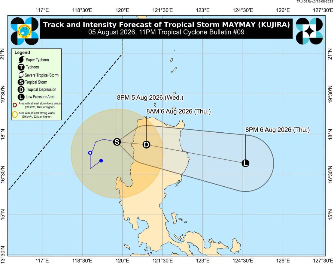
Tropical Storm Maymay gained speed late Wednesday as it moved closer to the Ilocos Sur–Ilocos Norte area, according to the Philippine Atmospheric, Geophysical and Astronomical Services Administration (PAGASA).
Signal No. 2 remained hoisted in 10 areas, while 16 areas are under Signal No. 1.
In its 11 p.m. tropical cyclone bulletin, PAGASA said the center of Maymay was estimated over the coastal waters of Magsingal, Ilocos Sur.
The storm packs maximum sustained winds of 75 kilometers per hour near the center and gusts of up to 90 km/h.
Maymay is moving eastward at 20 kph, a faster pace than in previous bulletins as it continues to approach the Ilocos Sur–Ilocos Norte area.
PAGASA advised residents in areas under tropical cyclone wind signals and those along the storm's forecast track to continue monitoring official weather advisories and take necessary precautions against possible strong winds, heavy rainfall, and rough seas.
Areas under Signal No. 2:
- Ilocos Norte
- Ilocos Sur
- the northern and central portions of La Union (Luna, Caba, Santol, Bauang, City of San Fernando, San Juan, Bagulin, Aringay, Bangar, San Gabriel, Burgos, Naguilian, Bacnotan, Sudipen, Balaoan)
- the northwestern portion of Pangasinan (Anda, Bolinao, Bani)
- the western portion of Apayao (Conner, Kabugao, Calanasan)
- Abra
- the western portion of Kalinga (Pasil, Tinglayan, Balbalan, Lubuagan)
- the western portion of Mountain Province (Besao, Tadian, Bauko, Sagada, Sabangan, Bontoc, Sadanga)
- the northwestern portion of Benguet (Mankayan, Kapangan, Kibungan, Sablan, Bakun, La Trinidad, Tublay, Atok, Buguias)
- the northwestern portion of Cagayan (Santa Praxedes, Claveria)
Areas under Signal No. 1:
- the rest of La Union
- the rest of Pangasinan
- the rest of Apayao
- the rest of Kalinga
- the rest of Mountain Province
- Ifugao
- the rest of Benguet
- the southern portion of Babuyan Islands (Calayan Is., Dalupiri Is, Fuga Is., Camiguin Isl.)
- the rest of mainland Cagayan
- Isabela
- Quirino
- Nueva Vizcaya
- the northern portion of Zambales (Candelaria, Santa Cruz, Masinloc, Palauig)
- the northern portion of Tarlac (Mayantoc, San Clemente, Camiling, Santa Ignacia, Gerona, Paniqui, Moncada, San Manuel, Anao, Ramos, Pura, Victoria)
- the northern portion of Nueva Ecija (Carranglan, Lupao, Cuyapo, Talugtug, Nampicuan, Guimba, Science City of Muñoz, San Jose City, Pantabangan, Bongabon, Rizal, Llanera, Talavera, Santo Domingo, General Mamerto Natividad, Quezon, Licab)
- the northern and central portions of Aurora (Dilasag, Casiguran, Dinalungan, Dipaculao, Baler, San Luis, Maria Aurora)
PAGASA said the Southwest Monsoon and the periphery of Maymay will bring strong to gale-force gusts over parts of the country, especially in coastal and upland areas exposed to winds, from Thursday to Friday.
Maymay will move generally eastward and may make landfall in the vicinity of Ilocos Sur or Ilocos Norte Wednesday night or Thursday early morning. Afterwards, it will traverse the mountainous terrain of Northern and Central Luzon before emerging over the eastern coastal waters of Isabela or Cagayan.
Maymay is forecast to remain as a tropical storm until it makes landfall in the vicinity of Ilocos Sur or Ilocos Norte, PAGASA added.—LDF, GMA News

