

 GMA Brandtalk
 Tracking
 Archives

Typhoon Saudel to enter PAR on Monday; Habagat to bring rains over Luzon
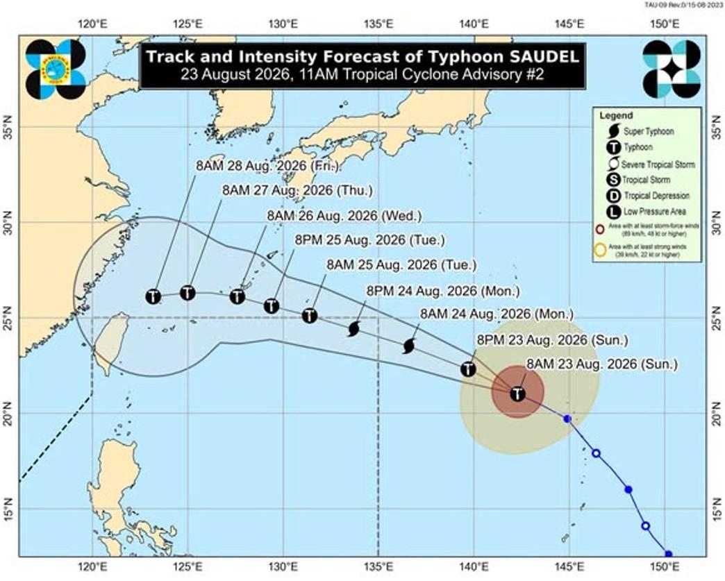
Typhoon Saudel is expected to enter the Philippine Area of Responsibility (PAR) on Monday. The Southwest Monsoon (Habagat) meanwhile, will bring cloudy skies with scattered rains over Northern and Central Luzon, PAGASA said.
Latest data issued early Monday show Saudel at 1,660 kilometers east northeast of extreme Northern Luzon packing maximum sustained winds of 175 kilometers per hour near the center, gustiness of up to 215 km/h and moving west northwestward at 25 km/h.
Saudel may enter PAR on Monday morning or afternoon and will then be given the local name Obet.
It will have no direct effect yet today on the weather condition, but it will enhance the Southwest Monsoon which will bring rains in the next few days.
According to PAGASA's Tropical Cyclone Advisory No. 3 issued 11 p.m. Sunday and valid until 11 a.m. Monday, Saudel is expected to still be outside PAR at 8 a.m. Monday as a typhoon.
However, by 8 p.m. Monday, Saudel is seen to be already inside PAR at 1,270 km east northeast of Extreme Northern Luzon as a super typhoon with winds of 185 km/h and moving west northwest at 25 km/h.
Saudel is expected to be outside PAR by Tuesday morning as a typhoon.
PAGASA is also currently monitoring two other weather disturbances:
- A tropical depression located 1,330 kilometers east of southeastern Luzon, packing maximum sustained winds of 55 km/h near the center, gustiness of up to 70 km/h and moving in the north northeast direction at the speed of 10 km/h.
- Tropical Depression Gaenari (formerly Neneng) located 520 kilometers north of Itbayat, Batanes, packing maximum sustained winds of 55 km/h near the center, gustiness of up to 70 km/h and moving west southwestward at the speed of 15 km/h.
Habagat
Batanes will have occasional rains on Monday due to the Southwest Monsoon and flash floods or landslides may occur due to moderate to heavy rains.
The province will have 50 to 100 mm of rainfall today, according to PAGASA's heavy rainfall outlook due to the Southwest Monsoon.
Metro Manila, Ilocos Region, Cordillera Administrative Region, Central Luzon, the rest of Cagayan Valley, Cavite, Batangas, and Rizal will have cloudy skies with scattered rains and thunderstorms due to the Southwest Monsoon with the possibility that flash floods or landslides will occur due to moderate to at times heavy rains.
The rest of the country will have partly cloudy to cloudy skies with isolated rain showers or thunderstorms due to localized thunderstorms while flash floods or landslides may still occur during severe thunderstorms.
Forecast wind and coastal water conditions
The northern and western sections of Luzon will experience moderate to strong winds moving southwestward while coastal waters will be moderate to rough.
The rest of the country will experience light to moderate winds moving in the south to southwest direction. Coastal waters will be slight to moderate.
Sunrise will be at 5:43 a.m., sunset at 6:14 p.m. — BAP/KG, GMA News

