


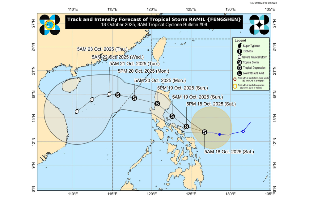
Tropical Storm #RamilPH slowed down Saturday morning as it moved west-northwest over the sea east of Sorsogon, according to PAGASA.
As of 7 a.m., the storm’s center was spotted 260 kilometers east of Juban, Sorsogon, packing maximum sustained winds of 65 kilometers per hour near the center and gusts of up to 80 km/h. It was moving west-northwest at 15 km/h.
Tropical Cyclone Wind Signal No. 2 was raised over parts of Bicol where gale-force winds are expected within 24 hours, posing minor to moderate threats to life and property.
Areas under Signal No. 2 (gale-force winds, 62–88 km/h)
- Camarines Norte
- Catanduanes
- Northern portion of Camarines Sur (Tinambac, Siruma, Goa, San Jose, Lagonoy, Garchitorena, Caramoan, Presentacion)
- Polillo Islands
Areas under Signal No. 1 (strong winds, 39–61 km/h)
- Cagayan including Babuyan Islands
- Isabela
- Quirino
- Nueva Vizcaya
- Apayao
- Abra
- Kalinga
- Mountain Province
- Ifugao
- Benguet
- Ilocos Norte
- Ilocos Sur
- La Union
- Pangasinan
- Aurora
- Nueva Ecija
- Eastern portion of Bulacan (Doña Remedios Trinidad, Norzagaray, San Miguel, San Ildefonso, San Rafael, Angat)
- Eastern portion of Tarlac (Camiling, San Clemente, Santa Ignacia, Paniqui, Moncada, San Manuel, Anao, Ramos, Pura, Victoria, City of Tarlac, La Paz, Concepcion, Gerona)
- Eastern portion of Pampanga (Magalang, Arayat, Candaba)
- Northern and eastern portions of Quezon (Tagkawayan, Perez, Alabat, Quezon, Atimonan, Padre Burgos, Unisan, Gumaca, Plaridel, Agdangan, Pagbilao, Mauban, Calauag, Guinayangan, Lopez, Pitogo, Macalelon, General Luna, Catanauan, San Narciso, Buenavista, San Francisco, San Andres, Mulanay, General Nakar, Infanta, Real, Sampaloc) including Polillo Islands
- The rest of Camarines Sur
- Albay
- Sorsogon
- Burias Island
- Ticao Island
- Northern Samar
- Northern portion of Eastern Samar (San Policarpo, Arteche, Oras, Dolores, Maslog, Jipapad, Taft, Can-Avid)
- Northern portion of Samar (Matuguinao, San Jose de Buan, Calbayog City, Gandara, Santa Margarita, Pagsanghan, San Jorge)
PAGASA said Ramil may make landfall or pass close to Catanduanes this afternoon or evening.
It will then move near Vinzons, Camarines Norte, and the Polillo Islands by Sunday morning before heading toward Aurora or Isabela for another possible landfall.
The storm is forecast to cross Northern and Central Luzon and exit toward the West Philippine Sea by Monday morning.
The weather bureau added that Ramil could still intensify into a severe tropical storm before landfall. The highest wind signal that may be raised during its passage is Signal No. 3.
Coastal communities in Isabela, Aurora, Quezon, Bicol, and Eastern Visayas were warned of possible storm surges up to two meters high within the next 48 hours. Rough to very rough seas are also expected over the eastern seaboards of Southern Luzon, where sea travel is risky for all vessels.
