






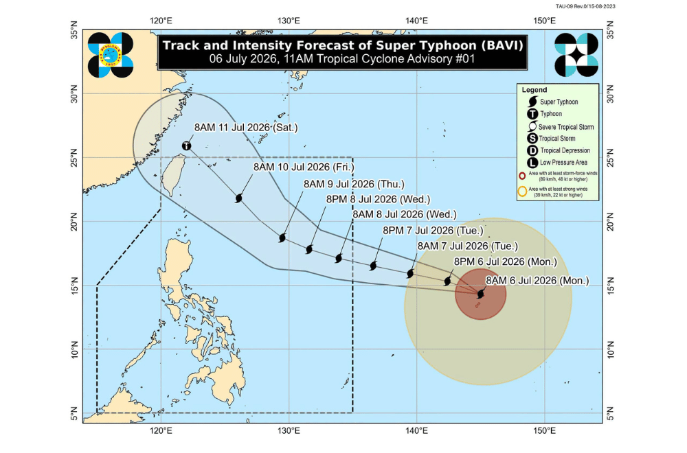
Super Typhoon Bavi is expected to enter the Philippine Area of Responsibility (PAR) between evening on Tuesday, July 7, 2026, and early Wednesday, July 8, where it will be given the local name #IndayPH, while maintaining its powerful strength, the state weather bureau said.
In its first tropical cyclone advisory issued at 11 a.m., PAGASA said the center of Bavi was estimated at 2,215 kilometers east of Southeastern Luzon, still outside PAR.
The typhoon packed maximum sustained winds of 205 kilometers per hour, gusts of up to 250 kph, and was moving west-northwestward at 20 kph.
PAGASA said Bavi is forecast to move generally west-northwestward over the Philippine Sea toward the Ryukyu Islands.
It is expected to remain a super typhoon as it enters PAR before gradually weakening as it passes near Extreme Northern Luzon and approaches eastern Taiwan.
Although the chance of landfall in Luzon remains low, PAGASA warned that the typhoon's large size and powerful winds could still affect the country. Wind signals may be raised over the northern and eastern parts of Northern Luzon as early as Tuesday night or Wednesday morning, with the highest possible warning likely reaching Signal No. 2 or 3.
The weather bureau also said wind signals may still be raised over the eastern parts of Southern Luzon and the Visayas, depending on the extent of the typhoon's strong winds.
Meanwhile, the enhanced Southwest Monsoon, together with the typhoon, is expected to bring gusty conditions across most parts of the country beginning Tuesday through Wednesday. Heavy rains are also expected over the northern and western parts of the Philippines, and PAGASA said it may issue a separate weather advisory for these hazards.
For coastal waters, a Gale Warning for rough to very rough seas over the northern and eastern seaboards of the country is expected to be issued by Wednesday.
PAGASA advised the public and local disaster management offices to continue monitoring official weather updates as Bavi moves closer to the country.