






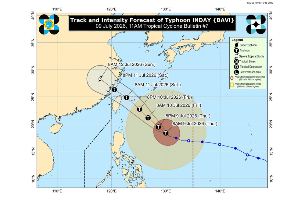
Typhoon #IndayPH (international name: Bavi) slightly weakened on Thursday, July 9, 2026, as it continued moving northwest over the Philippine Sea.
In its 11 a.m. bulletin, the Philippine Atmospheric, Geophysical and Astronomical Services Administration (PAGASA) said Inday was estimated 865 kilometers east of Northern Luzon as of 10 a.m. The typhoon packed maximum sustained winds of 165 kilometers per hour, gusts of up to 205 kph, and was moving northwest at 15 kph.
Areas under Wind Signal No. 2 (gale-force winds, 62–88 km/h)
- Batanes
Areas under Wind Signal No. 1 (strong winds, 39–61 km/h)
- Cagayan including Babuyan Islands
- Isabela
- Northeastern portion of Quirino (Maddela)
- Apayao
- Northern portion of Abra (Tineg, Lagayan, Danglas, San Juan, Lagangilang, Licuan-Baay, Malibcong, Lacub, Daguioman, Dolores, La Paz)
- Kalinga
- Eastern portion of Mountain Province (Natonin, Paracelis)
- Eastern portion of Ifugao (Aguinaldo, Alfonso Lista)
- Ilocos Norte
- Northern portion of Aurora (Dilasag, Casiguran)
- Northern and central portions of Catanduanes (Pandan, Caramoran, Bagamanoc, Panganiban, Viga, Gigmoto, Baras, San Miguel)
PAGASA said the typhoon's outer circulation, together with the enhanced southwest monsoon, could bring strong to gale-force wind gusts over most parts of the country through Saturday, July 11.
The weather bureau also warned of dangerous sea conditions, with waves reaching up to six meters along the seaboard of Batanes and the northern and eastern coasts of the Babuyan Islands and mainland Cagayan. Sea travel remains risky in affected waters, and mariners were advised to stay in port or seek safe harbor.
Other coastal areas in Luzon, Visayas, and parts of Mindanao may also experience rough to very rough seas, prompting authorities to advise small vessels and motorized bancas not to venture out.
PAGASA said Inday is expected to continue moving northwest over the Philippine Sea and may pass closest to Extreme Northern Luzon between Friday evening and Saturday morning.
The typhoon is then forecast to move toward the southern islands of Japan before passing close to or making landfall along northern Taiwan. It is expected to leave the Philippine Area of Responsibility (PAR) by Saturday and later make landfall over eastern China, where it is forecast to weaken after moving inland.
PAGASA reminded residents in areas vulnerable to flooding, landslides, strong winds, and storm surges to monitor official advisories and follow evacuation orders from local authorities if necessary.