

Somewhere out there is our unmarked border
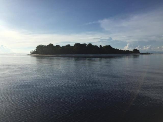
Panguan Island is but a sandy speck in the sea, visible on Google Maps only if you zoom in tight. But it is the only place I have been in the Philippines where another country is visible.
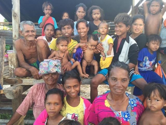
Standing on Panguan’s immaculate western beach, you can see the dark outlines of Malaysia, to where the two dozen or so Badjaos now living on the island sail to sell their fish catch and buy rice and other provisions.
Somewhere out there in the sea is the unmarked border between the Philippines and Malaysia.
Most other Filipinos see borders as airports. You fly in, present your papers and you're suddenly in another country. Obviously, as an island nation, we don't have the option of driving or taking a bus or train across the border the way Americans can to Canada, or Malaysians to Thailand.
In the modern age of travel, we often forget about the sea, even if it's all around us. Some might think it tends to isolate island countries, especially when you stand in Palawan or Aurora and see only empty horizons.
On the contrary, the sea has connected us to the rest of the world since time immemorial. It is the high rugged mountains elsewhere that have been more of a barrier in landlocked places.
The sea still provides the freest form of international travel on the planet. Or at least that seems to be the case when you spend time on the southernmost tip of our archipelago, Panguan Island.
Civilian island residents there cross to the nearest land mass, Sabah, as they please, generally tolerated by Malaysian authorities and blending in with local communities, many of which are populated by blood relations from Tawi-Tawi. In Sitangkai, the Tawi-Tawi town built on water, most of the goods in stores are untaxed products from Malaysia.
Back door
That's the way it's always been in the so-called "back door" of the country, with none of the formalities or restrictions of front door airports. It's duty-free in its original and purest form.
This border region has been mostly a zone of interaction, not restriction, where Badjaos, Tausugs, Bisayans, and Chinese traded and intermarried for centuries
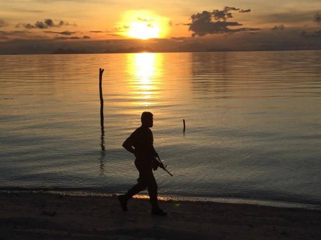
Panguan in a way is a microcosm of the region, with the native Badjaos living harmoniously on the island with another group, a detachment of nine Philippine Marines who hail from nine different places in the country, with three from all the way in northern Luzon.
Both Badjaos and military are new residents. For years, Panguan was a no man's land, except if you were a member of the Abu Sayyaf or other pirate gangs that used to ply these waters and victimize Badjaos and other sea travelers. For them, Panguan was a convenient stopover for rest and recreation in between kidnapping safaris. So even if on maps the dot of land was part of the Philippines, in reality it belonged to pirates.
Earlier this year, the armed forces decided to end that de facto occupation when it sent the Marines to assault Panguan's beaches, only to find a vacant island. They have since established what appears to be a permanent presence in the form of barracks with a concrete foundation, and a flagpole with the Philippine flag lit up at night. With speedboats and a new Philippine-made multi-purpose attack craft (MPAC) at its disposal, the Marines have finally established sovereign control of what used to be a lawless border region.
Markers of possession
Their constant alertness and nighttime patrols reminded me that a map is not enough for a country to claim a piece of property.
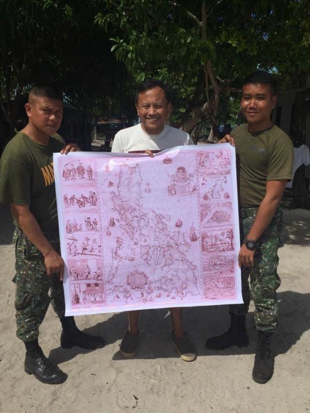
That's why despite the Philippines' victory over China in the international tribunal last year, we have basically lost possession of Panatag Shoal, which is called Panacot on a 1734 map by a Spanish cartographer that was used as proof of Philippine ownership.
Diplomacy, legal action, and international pressure will take a country's claims only so far if your adversary is willing to eschew all that and simply use force.
Looking closely at the Murillo Velarde map of 1734, used to great effect at the tribunal in The Hague, I noticed that while Panacot is indeed clearly marked part of the archipelago, Tawi-Tawi is not.
That only shows that at the time, Tawi-Tawi's garland of 209 islands that stretch to Borneo was not under Spanish control and became part of the territory only in the 20th century.
Yet one can imagine that years from now, the same vintage map can be used to turn the tables on us and claim that Panguan and the surrounding islands really belong to an adjoining country.
Hence the need for tangible markers of possession, such as the flag, the Marine barracks and weaponry, and the burgeoning community of Badjaos (who by the way do not have birth certificates, passports, or other proof of citizenship). The Coast Guard is planning a lighthouse on the island, not mainly to guide boats but as a beacon of our sovereignty.
Salve for the soul
There was a time when people spoke of a borderless world, when countries began to loosen restrictions on the movement of goods and people. Then came the internet, that great global highway that transcended borders and made the entire world a warm and fuzzy zone of interaction.
That seems an eternity ago. The world may now be headed in the opposite direction, with Donald Trump endlessly tweeting about border walls, trade barriers, and a ban based on religion; and the Philippines' own Rodrigo Duterte warming up to Trump and cursing the United Nations.
The internet in general, and Facebook in particular, have been blamed for the rise of vulgar populists, fake news, and the spread of hate. We may be on the cusp of a major rebellion against social media, with some liberal governments trying to put the Facebook genie back in a bottle, as authoritarians continue to give it a bad name. What broke down barriers has fueled conditions for making walls rise again, with smaller countries at risk of being on the outside looking in.
In the meantime, as the Philippines plays footsies with China, we continue to lose territory and swallow our pride. The only thing permanent about borders is their impermanence, especially in a new world order where words mean less and aircraft carriers loom even larger.
That's why the visit to tiny Panguan was salve for the soul, where Filipinos have quietly planted stakes in its defense. No longer a no man's land, this was a faraway place that was clearly ours. For now.
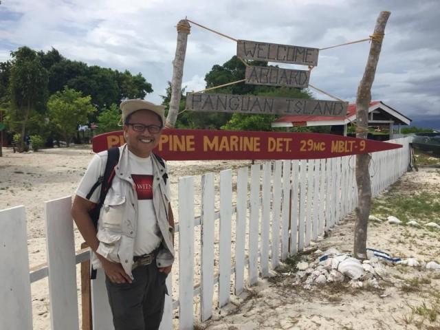
Howie Severino and his team produced “Ang Huling Isla", part of a series of documentaries on borders for I-Witness. Watch the full documentary below:
—JST, GMA News
