

Diwata-1’s photos of Zamboanga and Florida from 400 km above the Earth
The Philippines' first microsatellite, Diwata-1, has released high-resolution images taken by its High Precision Telescope (HPT).
In a statement, the Philippine Council for Industry, Energy, and Emerging Technology Research and Development (PCIEERD) of the Department of Science and Technology announced that the HPT—one of the Diwata-1's four cameras—took the images during the satellite's test phase.
PCIEERD posted a side-by-side comparison of a photo taken by Diwata-1's HPT on May 19 and one taken by the Operational Land Imager (OLI) of the 2,600-kg US satellite Landsat 8 on May 21. The photos are of the town of Dumingag in Zamboanga del Sur.
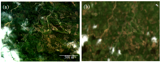
Diwata-1's photo (left) is clearer than Landsat 8's (right), with even man-made structures visible.
The HPT's images have a ground resolution of 3m at nadir (lowest point), which PCIEERD says is the highest resolution attained by a 50-kg microsatellite. The OLI's image has a ground resolution of 30m.
"With a clearer photo from Diwata 1’s HPT camera, it will be easier to see which areas are affected by natural and even man-made disasters such as floods and fires," PCIEERD said. "It may be recalled that one of the missions of the HPT is to determine the extent of damages from natural hazards such as typhoons."
Another comparison of photos taken by the HPT and the OLI. This time, the photos show an urban area in the US state of Florida. The PCIEERD noted that these are "false color" images, which are "created to emphasize the difference between vegetation and other objects[.]"
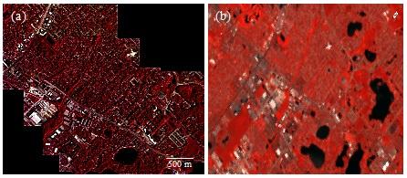
The image on the left was created by stitching together six images taken by Diwata-1's HPT camera with one-second intervals. PCIEERD said that the image is evidence of the microsatellite's target pointing capability, with the HPT "able to capture six images of the focused area with field-of-view of 2 km x 1.5 km even though it was orbiting the earth with a velocity of ~7.7 km/s at an altitude of ~400 km," it said.
Again, man-made structures such as buildings and roads are clearly distinguishable from the vegetation in the HPT photo, unlike the OLI's image on the right.
"The ability of Diwata 1’s HPT camera to take pictures of places even outside the country is a good indication that we can attain one of the objectives of our microsatellite development program which is to be able to share and exchange images among a group or constellation of microsatellites with our neighboring countries for mutual benefit," said the PCIEERD.
Diwata-1 was sent to the International Space Station on March 23 as part of the payload of Orbital ATK's Cygnus spacecraft, which lifted off from Cape Canaveral in Florida. It stayed on board the ISS until April 27, when it was launched into orbit 400 kilometers above the Earth.
Diwata-1 was co-developed by the Department of Science and Technology (DOST), the University of the Philippines, Hokkaido University, and Tohoku University for scientific earth observation, including weather monitoring. — BM, GMA News
