

‘Peace park’ best way out of WPS conflict – marine scientist
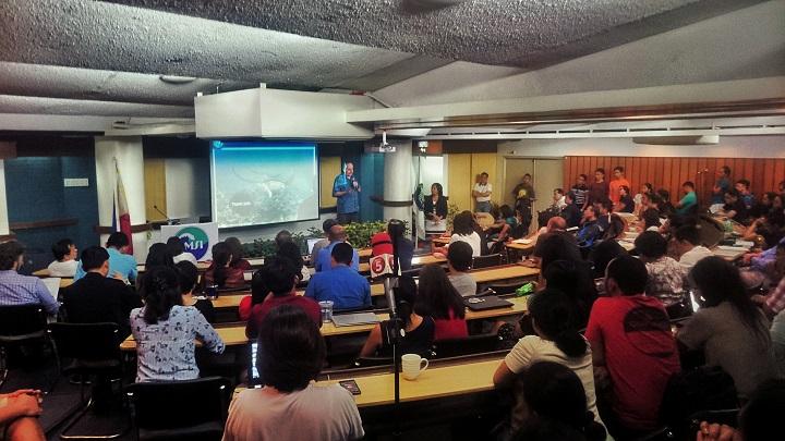
A "peace park" is the best solution to the West Philippine Sea conflict, marine ecologist Dr. John McManus of the University of Miami said at a seminar at the University of the Philippines' Marine Science Institute (UP MSI) earlier this month.
McManus' involvement with the West Philippine Sea—the portion of the South China Sea claimed by the Philippines—traces back to the 1980s, when he conducted research in fisheries and coral reef ecology in UP MSI's Bolinao Marine Laboratory in Bolinao, Pangasinan. His years of research led to the publication of a plan for the Spratly Islands Marine Park in 1992.
Damage to coral reefs
All of the natural islands in the WPS are coral islands constructed by thousands of years' worth of coral reef growth and erosion to sand, cemented together by bird guano.
In 2014, China ramped up their island-building activities in the West Philippine Sea, and several atolls now contain air strips, radar, and housing facilities.
Building an island involves using cutter suction dredges to dig into and crush live coral, dead coral, and reef substrate to produce sand and gravel, which is then sucked up into floating pipes and deposited onto the reef flat.
"People say reef flats are usually sand. In some parts of the world, they usually are. But in the [West Philippine Sea], they're usually coral," said McManus.
"The coral patches in the reef flat are extremely important. They don't cover a lot of area in lagoons as the lagoon is mostly sand, but every patch is an oasis. Life is heavily dependent on these clumps. If you take out a clump, that's a huge area that will no longer have fish wandering around."
McManus took exception to China's description of its construction as simulating the natural process of island creation.
"I say 'No, you're simulating what I did in my backyard when I built a sandbox'," he said. "You don't have any long-term accretion processes. There's no bird guano involved. You're not generating new calcium carbonate; you're actually using up the reef to do it."
McManus considers Mischief Reef (Panganiban Reef) to be one of the saddest stories of all. "[Panganiban Reef] was a beautiful reef. It's about 7 kilometers across, so the whole area is about 18 kilometers—and it's been filled in. We know that virtually everything is gone. Everything is dead. They asked me to look at a closeup image that showed these tendrils of silt coming off [the reef]. Silt doesn't make tendrils. Silk makes clouds. The tendrils are probably mucus being exuded by millions and millions of dying coral heads that mixes with the silt."
But the damage to the WPS was happening long before the island-building began. Chinese fishers gathering giant clams anchored their boats to the reef, spun their motor blades, and pulled on the boat, creating sweeping arcs where the boat's motor blades crushed the reef underneath and removed the clams.
"China was saying that they sent their scientists out and they said that these areas where they built the islands were all dead corals. I'm thinking that scientists don't lie, so why would their scientists say that?" said McManus. "We have photos from 2011 that show the giant clam boats that tore the coral reefs all up. The scientists weren't lying because the Chinese fishers already killed all the coral."
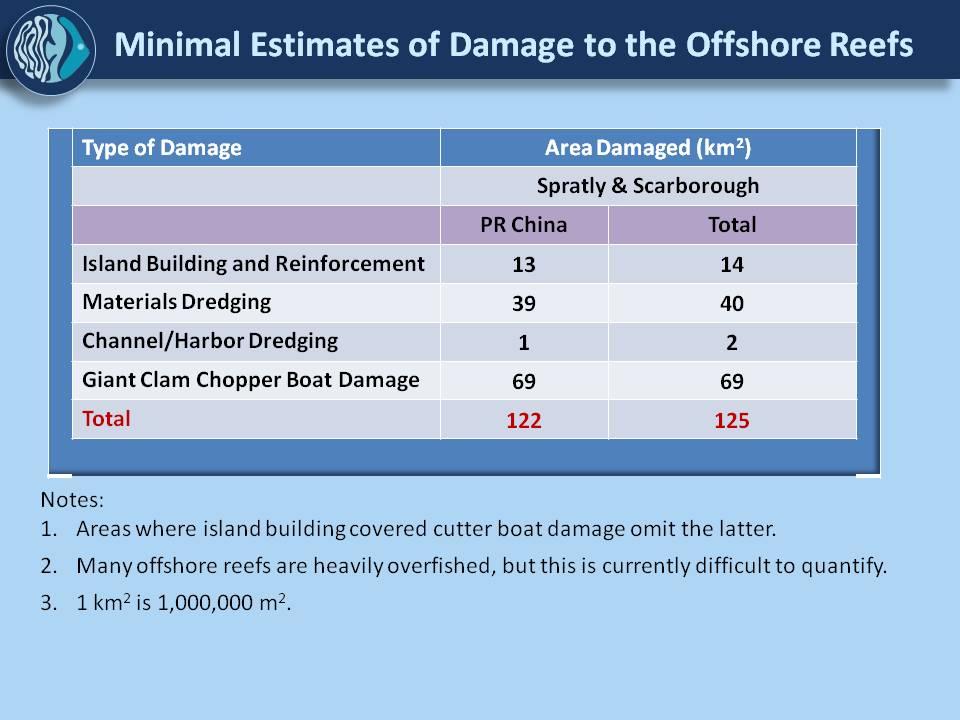
McManus estimates that at least 122 square kilometers of coral reef in the Spratlys and Scarborough Shoal have been damaged by Chinese activities: 13 sq. km. due to island building and reinforcement, 39 sq. km. due to materials dredging, 1 sq. km. due to channel and harbor dredging, and 69 sq. km. due to giant clam chopper boats.
In comparison, the other country claimants to the WPS have caused a combined damage of 3 sq. km.
McManus stresses that this damage estimate is low as he only included areas that he was sure of: the lagoons. "Most of the digging was from forereef slopes—the spurs and grooves in deeper reefs—and I can't quantify that." Satellite data and field observations from 2014 to early 2016 were used to investigate the cause and extent of the damage.
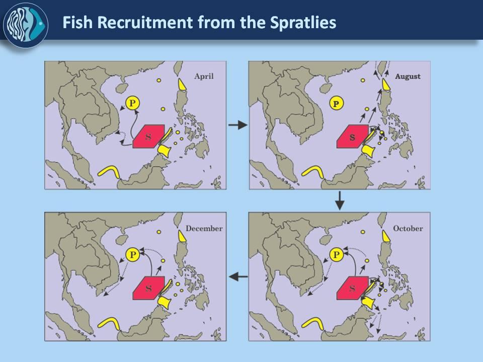
The damage to the corals in the WPS may have large impacts on fisheries in the Philippines. "We studied the fish populations in Bolinao for seven years, where I had a team of people counting 600 species of fish every other month," said McManus.
"And we noticed that just about every year, a few species would disappear. And then maybe a year or two later, they would come back. We figured out that the whole coastline [along the WPS], with the exception of Brunei, is overfished at about double of what it should be and it's been like that for a long time, so the fish couldn't be coming from there. It was Perry Alino [of UP MSI] who actually suggested that they were coming from the Spratlys. So I did this little analysis using charts from Hawaii using ship drift information and we showed that yes, the fish can survive here."
Why a peace park?
With a peace park, said McManus, nobody loses in a situation where "it's very difficult to imagine any scenario where you're going to divide things up."
For another thing, there's no oil and gas to fight over. "One of the reasons why people didn't like the idea of the peace park back in the early 1990s when we first proposed it was, 'Oh there's oil there and nobody wants to drill for oil in a park.' When you hear someone say that the [West Philippine Sea] is rich in oil and gas, that's correct. But around the islands and reefs themselves, it's now believed that there's virtually no oil and very little gas.
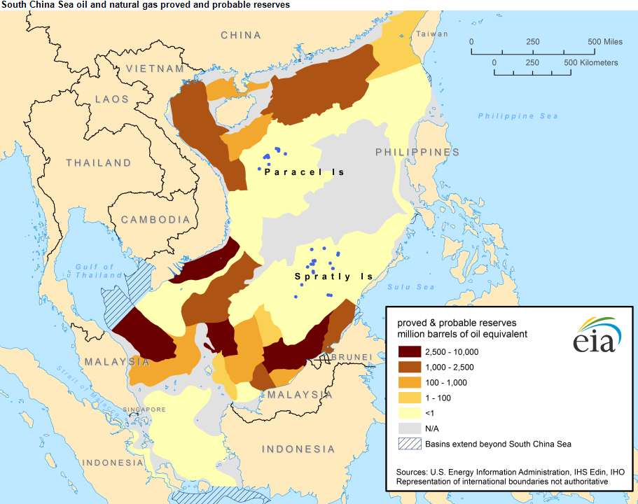
"Part of the reason why we believe that's true is that in order to have gas and oil build up, you need to have a porous material that's overlain by something that's not porous. You don't have that out there. You have these reefs which many people now think act like chimneys and they're all full of holes, so the oil and gas would have escaped long ago. Very few people of any knowledgeable credibility in the oil industry have any interest at all in drilling in the reefs. Now, we would have liked it to be, 'Don't drill because you're going to screw up the wonderful ecosystem,' but we'll take what we can get."
Shooting at each other means big economic trouble. "About $5 trillion of shipments go through the [West Philippine Sea] each year. Eighty percent of the trade that goes to China goes through the [WPS]. Sixty percent of the oil and gas going to Japan, Taiwan, and South Korea pass through here. If you stop [trade] for a day, that's billions of dollars per day that you're going to lose. After a week or two, China's going to lose a lot of its trade and oil. If China falters, the US falters because we're heavily cross-invested," said McManus.
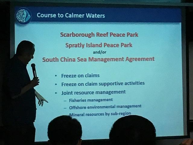
Joint resource management would be necessary for a peace park to work. McManus said that marine scientists are planning what he is calling the Scarborough Reef Peace Park. "This is the immediate low-hanging fruit because it could be done bilaterally. It becomes the Spratly Island Peace Park if Malaysia and Vietnam get excited about this. If you can't have that, you at least have to have the [West Philippine Sea] Management Agreement for fisheries," he said.
Otherwise, he said, there's going to be a big problem. "There are about 200 million people along the coastline of the [WPS] and 38 million people are in poverty. The main source of protein is fish. If we have major [fisheries] collapse in the [WPS], we're going to have starvation," he said.
"If one country, like China, tries to impose its summer ban on fishing, the response of both Vietnam and the Philippines is to send more people out. You need to violate a regulation in a dispute like this because if you recognize a unilateral decision, you're recognizing their authority over the territory. Anyone who tries to make a rule without coordinating it with the others is actually making things worse. So there is no other solution other than joint resource management."
What would a peace park entail?
The peace park agreement is based on the Antarctic treaty, with a suggested renewal of 30 or 50 years. McManus said that the Antarctic treaty would work, for two reasons.
"First: you freeze the claims. Nobody loses anything. You just agree to disagree and you're not allowed to change what you claim during the time of the treaty. Second: you freeze the claim-supportive activities. You agree in the treaty that nothing that you do during the treaty could ever be used to support your claim. These are the two key things that provide stability. The third of course is joint resource management. You'd have a fisheries management committee and offshore environmental management."
McManus is hopeful that this can happen. "A number of recent analyses came to the conclusion that it's either this [the peace park] or armed conflict, so suddenly there's a lot of interest in all of this when there wasn't in the last few years," he said. — BM, GMA News
