

Rolly to hit NCR, southern Luzon; Signal No. 3 in Catanduanes, parts of CamSur, Albay
Tropical Cyclone Wind Signal No. 3 remained hoisted in Catanduanes, the eastern portion of Camarines Sur, and Albay on Saturday afternoon as Typhoon Rolly maintained its strength while moving toward the Bicol Region.
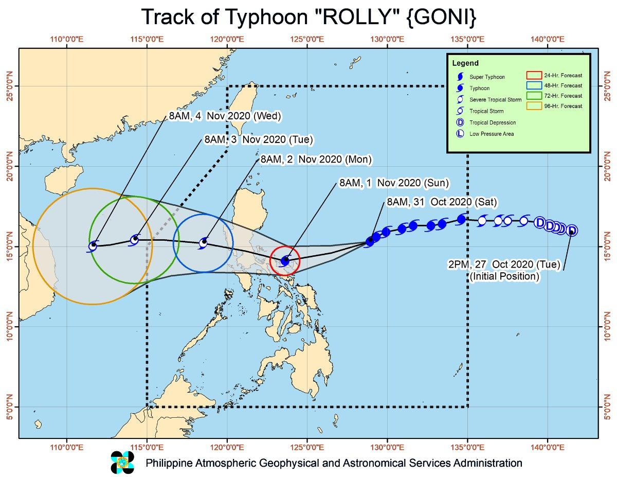
In its 5 p.m. bulletin, PAGASA said the center of the eye of Rolly is forecast to pass over Catanduanes to mainland Camarines Provinces area on Sunday morning, and over mainland Quezon on Sunday afternoon.
Rolly is then forecast to cross the Southern Luzon-Metro Manila area, before exiting the mainland Luzon landmass on Monday early morning.
PAGASA said winds of greater than 121 kph up to 170 kph may be expected within at least 18 hours in the following areas of the said provinces under Signal No. 3:
Luzon:
- Catanduanes
- the eastern portion of Camarines Sur (Cabusao, Libmanan, Pasacao, Pamplona, Magarao, Bombon, Calabanga, Canaman, Camaligan, Gainza, Naga City, Milaor, San Fernando, Minalabac, Pili, Ocampo, Baao, Bula, Balatan, Nabua, Bato, Iriga City, Buhi, Sagnay, Tigaon, Goa, Tinambac, Siruma, Lagonoy, San Jose, Garchitorena, Presentacion, Caramoan)
- Albay
Signal no. 2 is meanwhile raised over the following areas:
Luzon:
- Bulacan
- Rizal
- Metro Manila
- Laguna
- Cavite
- Batangas
- Quezon including Polillo Islands
- Camarines Norte
- the rest of Camarines Sur
- Sorsogon
- Masbate including Ticao and Burias Islands
- Marinduque
- Romblon
- Oriental Mindoro
- Occidental Mindoro including Lubang Island
Visayas
- Northern Samar
- the northern portion of Samar (Hinabangan, Paranas, Motiong, Jiabong, Catbalogan City, San Jose de Buan, San Jorge, Tarangnan, Gandara, Santa Margarita, Matuguinao, Calbayog City, Tagapul-An, Almagro, Santo Nino, Pagsanghan)
- the northern portion of Eastern Samar (San Julian, Sulat, Taft, Can-Avid, Dolores, Maslog, Oras, San Policarpo, Arteche, Jipapad)
The following areas meanwhile are under Signal no. 1:
Luzon:
- Pampanga
- Bataan
- Zambales
- Tarlac
- Nueva Ecija
- Aurora
- Pangasinan
- La Union
- the southern portion of Ilocos Sur (Quirino, Gregorio Del Pilar, Salcedo, San Emilio, Candon City, Galimuyod, Santa Lucia, Cervantes, Sigay, Santa Cruz, Suyo, Tagudin, Alilem, Sugpon)
- Mountain Province
- Benguet
- Ifugao
- Nueva Vizcaya
- Quirino
- and the central and southern portions of Isabela (Mallig, Quirino, Ilagan, Roxas, San Manuel, Burgos, Gamu, Palanan, San Mariano, Benito Soliven, Naguilian, Reina Mercedes, Luna, Aurora, Cabatuan, San Mateo, Cauayan City, Dinapigue, San Guillermo, Echague, San Agustin, Jones, Angadanan, Alicia, San Isidro, Ramon, Santiago City, Cordon)
- Calamian Islands
Visayas:
- rest of Eastern Samar
- rest of Samar
- northern portion of Leyte (Leyte, Tabango, San Isidro, Calubian, Capoocan, Carigara, Tunga, Barugo, San Miguel, Babatngon, Tacloban City)
- northwestern portion of Aklan (Numancia, Lezo, Makato, Tangalan, Ibajay, Nabas, Malay, Buruanga, Kalibo),
- northwestern portion of Antique (Libertad, Pandan)
Violent winds, intense rain
Catanduanes and Camarines Provinces will experience violent winds and intense rainfall associated with the inner rainband-eyewall region on Sunday early morning through afternoon and over Quezon in the afternoon through evening.
"Rolly" is likely to remain a typhoon category (185-205 km/h) by the time it makes landfall," PAGASA said.
As of 4 p.m. on Saturday, the eye of Typhoon Rolly was located based on all available data at 345 km east northeast of Virac, Catanduanes.
It is moving west southwestward at 25 kph with maximum sustained winds of 215 kph near the center and gustiness of up to 265 kph.
Rainfall
As of Saturday, the outer rainbands of Rolly will bring light to moderate with at times heavy rains over the Bicol Region and Eastern Visayas.
On Sunday early morning, Metro Manila, Bicol Region, CALABARZON, Aurora, Bulacan, Zambales, Bataan, Marinduque, Romblon, Occidental Mindoro, and Oriental Mindoro will experience heavy to intense rains due to the passage of the typhoon.
Cagayan Valley, Cordillera Administrative Region, Ilocos Region, and the rest of Central Luzon will meanwhile experience moderate to heavy rains with at times intense rains (especially the eastern sections of Northern and Central Luzon).
Flooding (including flash floods), rain-induced landslides, and sediment-laden streamflows (lahar) may occur during heavy or prolonged rainfall especially in areas that are highly or very highly susceptible to these hazards, PAGASA warned.
Storm surge
PAGASA warned that a high risk of storm surge of more than 3.0m will be experienced over the northern coastal areas of Quezon including Polillo Islands, Camarines Provinces, and Catanduanes.
A storm surge of 2.1 to 3.0m will be experienced over the coastal areas of Manila, Cavite, Bulacan, Pampanga, Bataan, the southeastern coastal area of Batangas and the southwestern coastal area of Quezon, and a surge of 1.0 to 2.0 m is expected over the coastal areas of Aurora, Zambales, Occidental Mindoro, the rest of the coastal areas of Bicol Region, Batangas, and Quezon in the next 24 hours.
PAGASA said this may result in life-threatening and damaging coastal inundation as the storm surge may be accompanied by swells and breaking waves reaching the coast.
Meanwhile, the center of Tropical Depression Atsani was estimated at 1,520 km East of Southern Luzon as of 4 p.m. on Saturday.
It currently has maximum sustained winds of 55 kph near the center and gustiness of up to 70 kph. It is moving northwestward at 25 kph and is forecast to enter the Philippine Area of Responsibility on Sunday afternoon.
PAGASA however said it remains less likely to affect any portion of the country over the next two to three days, but is likely to re-intensify into a tropical storm in the next 24 hours. - MDM, GMA News
