
Filtered By: Scitech
SciTech
Approaching tropical storm may steer clear of PHL
A tropical cyclone approaching the Philippine Area of Responsibility (PAR) has intensified into a tropical storm with the international codename Nuri, state weather agency PAGASA said Friday afternoon.
In its 5 p.m. bulletin, PAGASA said Nuri was estimated at 1,255 km east of Visayas, still outside the PAR as of 4 p.m. and not directly affecting the country.
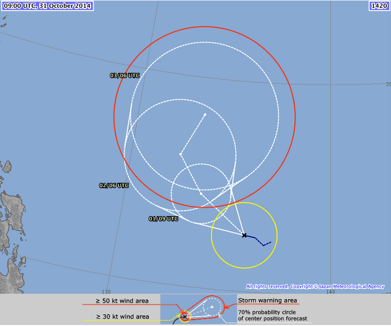
Nuri is still too far away for PAGASA to provide a clear forecast track, although the Japan Meteorological Agency's (JMA's) preliminary projections indicate that it is likely to steer clear of the Philippines and head north toward Japan instead.
Earlier Friday, PAGASA forecast the storm to enter the PAR Friday evening.
PAGASA said Tropical Storm Nuri packed maximum sustained winds of 65 kph near the center and gustiness of up to 80 kph and is forecast to move west-northwest at 15 kph.
Veering toward japan?
The JMA's 3:10 p.m. update indicated Nuri may change course Sunday afternoon and head north then northeast by Monday afternoon.
Northeast monsoon
PAGASA also said the Northeast Monsoon is affecting Northern Luzon.
It said Calabarzon, Bicol and Eastern Visayas will have cloudy skies with light to moderate rain showers and thunderstorms.
Cagayan Valley, Cordillera and Ilocos may expect partly cloudy skies with isolated light rain.
Metro Manila and the rest of the country will be partly cloudy to cloudy with isolated rain showers or thunderstorms.
Also, PAGASA said moderate to strong winds from the northeast to north will prevail over Luzon and its coastal waters will be moderate to rough.
Elsewhere, winds will be light to moderate coming from the northeast to northwest with slight to moderate seas. — Joel Locsin/TJD, GMA News
