

12 areas under Signal No. 1 as Ofel moves toward Marinduque, Romblon
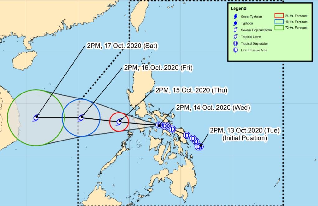
Twelve areas are now under Signal No. 1 as Tropical Depression Ofel maintained its strength and continued to move westward towards Marinduque and Romblon, PAGASA said in its latest severe weather bulletin.
Under TCWS No. 1 as of 5 p.m. were:
- Batangas
- the southern portion of Laguna (Luisiana, Majayjay, Liliw, Nagcarlan, Rizal, San Pablo City, Calauan, Alaminos, Los Baños, Bay, Magdalena)
- the central and southern portions of Quezon (Guinayangan,Tagkawayan,Buenavista,San Narciso,San Andres,Mulanay,San Francisco,Catanauan,Lopez,Calauag,Quezon,Alabat,Perez,Atimonan,Tayabas City,Mauban,Sampaloc,Lucban,Gumaca,General Luna,Macalelon,Pitogo,Unisan,Plaridel,Padre Burgos,Agdangan,Pagbilao,Lucena City,Sariaya,Candelaria,Dolores,Tiaong,San Antonio)
- Calamian Islands
- Occidental Mindoro
- Oriental Mindoro
- Marinduque
- Romblon
- Camarines Norte
- Camarines Sur
- Albay
- Masbate (including Ticao and Burias Islands)
PAGASA said Ofel would move west-northwestward or westward over the inland seas of Southern Luzon and may pass close or over Romblon and Mindoro provinces. It is likely to emerge over the West Philippine Sea on Thursday morning and exit the Philippine Area of Responsibility on Friday morning or afternoon.
The center of Ofel was seen 125 kilometers west of Juban, Sorsogon or 70 kilometers east northeast of Romblon, Romblon at 4 p.m. It is moving westward at 15 kilometers per hour and has a maximum sustained winds of 45 kph near the center and gustiness of up to 55 kph.
Hazards affecting land areas
PAGASA said Ofel would bring moderate to heavy, with at times, intense rains over CALABARZON, Camarines Norte, Marinduque, Romblon and Mindoro provinces from Wednesday to Thursday afternoon.
Meanwhile, light to moderate, with at times, heavy rains will be experienced over Central Luzon, Visayas, Mindanao, Metro Manila, Palawan, Cagayan, Isabela and the rest of Bicol Region due to Ofel and the southwest monsoon.
PAGASA advised affected residents to prepare for possible flash floods and landslides during heavy or prolonged rainfall.
Moreover, strong to near gale force winds will be experienced in areas under TCWS No. 1 during the passage of Ofel, while occasional gusts associated with the northeasterly surface wind flow can be expected over Batanes, the northern and eastern portions of Cagayan (including Babuyan Islands), the northern portions of Apayao, Ilocos Norte, and Quezon, the eastern portion of Isabela, and Aurora, especially in coastal and mountainous areas.
Hazard affecting coastal waters
PAGASA said gale warning is in effect over the seaboards of Batanes and Ilocos Norte and the northern seaboard of Cagayan, including Babuyan Islands due to rough seas associated with the northeasterly surface wind flow.
PAGASA said sea travel is risky over these areas, especially for those using small sea crafts.
Further, moderate to rough seas can be expected over the eastern seaboards of Luzon and Visayas in the next 24 hours, especially in areas where TCWS No. 1 is in effect. -NB, GMA News
