Quinta approaching Bicol; Signal No. 2 up over 14 areas —PAGASA

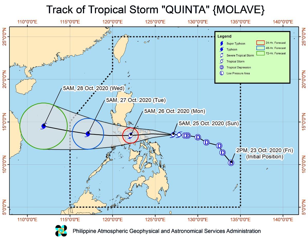
Tropical Cyclone Wind Signal No. 2 is raised over at least 14 areas due to Severe Tropical Storm Quinta, which is expected to make landfall over the Bicol on Sunday, state weather bureau PAGASA said.
In a 2 p.m. bulletin, PAGASA said areas under Signal No. 2 include:
- Catanduanes
- Camarines Norte
- Camarines Sur
- Albay
- Sorsogon
- Masbate including Burias and Ticao Islands
- Central and southern portions of Quezon (Mauban, Sampaloc, Lucban, Dolores, Candelaria, Tiaong, San Antonio, Sariaya, Tayabas City, Lucena City, Pagbilao, Atimonan, Perez, Alabat, Calauag, Quezon, Tagkawayan, Guinayangan, Lopez, Pitogo, Plaridel, Gumaca, Unisan, Agdangan, Padre Burgos, Macalelon, Catanauan, General Luna, Buenavista, San Narciso, Mulanay, San Andres, San Francisco)
- southeastern portion of Laguna (Paete, Kalayaan, Lumban, Cavinti, Luisiana, Majayjay, Liliw, Rizal, Nagcarlan, San Pablo City, Alaminos, Magdalena, Pagsanjan)
- Batangas
- Marinduque
- Romblon
- Oriental Mindoro
- Occidental Mindoro including Lubang Island
- Northern Samar
Meanwhile, PAGASA said Signal No. 1 is up over the following areas:
- the rest of Quezon,
- the rest of Laguna,
- Rizal,
- Cavite
- Metro Manila
- Bulacan
- Pampanga
- Bataan
- southern portion of Zambales (San Marcelino, San Felipe, San Narciso, Castillejos, Subic, San Antonio, Olongapo City, Botolan, Cabangan)
- Calamian Islands
- northern portion of Samar (Calbayog City, Matuguinao, Tagapul-An, Santo Nino, Almagro, Santa Margarita, Gandara, San Jose de Buan, Pagsanghan, Tarangnan, San Jorge, Catbalogan City, Jiabong, Motiong, Paranas)
- northern portion of Eastern Samar (Maslog, Jipapad, Arteche, San Policarpo, Oras, Dolores, Can-Avid, Taft)
- northern portion of Capiz (Sapi-An, Ivisan, Roxas City, Panay, Pilar, Pontevedra, President Roxas)
- Aklan
- northern portion of Antique (Caluya, Libertad, Pandan, Sebaste, Culasi)
- northeastern portion of Iloilo (Batad, Balasan, Estancia, Carles)
Moderate to intense rain
Due to Quinta, moderate to heavy with at times intense rains are expected over Bicol Region, CALABARZON, Aurora, Occidental Mindoro, Oriental Mindoro, Romblon, Marinduque, Calamian Islands, Northern Samar, Eastern Samar, Samar, Biliran, Aklan, and Antique.
Same weather conditions will be experienced over Cagayan, Isabela, Apayao, and Ilocos Norte due to the tail-end of a frontal system.
These weather systems will also cause light to moderate with at times heavy rains over Metro Manila and the rest of Luzon, Zamboanga Peninsula, Bangsamoro, Northern Mindanao, Caraga, and the rest of Visayas.
PAGASA warned of possible flooding rain-induced landslides, and sediment-laden stream flows like lahars) during heavy or prolonged rainfall in areas prone to these hazards.
In areas under Signal No. 2, stormy conditions are expected, while areas under Signal No. 1 will experience strong breeze to near gale conditions.
Due to the northeasterly surge, Batanes, Babuyan Islands, and the northern coastal areas of Ilocos Norte, and mainland Cagayan will experience strong breeze to gale conditions.
PAGASA warned of storm surge of up to 2.0 meters that may affect the coastal areas of Northern Samar, Bicol Region, and the central and southern portions of Quezon.
Rough to very rough seas are expected over the entire seaboards of Northern Luzon (up to 5.5 m), the seaboards of Aurora, Zambales, and northern Palawan including Calamian and Kalayaan Islands --with wave height of up to 4.5 meters.
Same sea condition will be experienced in areas under Signals No. 1 and 2, with waves up to 5.5 meters.
“Sea travel is risky over these waters, especially for small sea crafts,” PAGASA warned.
PAGASA added that moderate to rough seas (up to 2.8 m) are expected over the other seaboards of the country.
“Mariners of small sea crafts are advised to take precautionary measures when venturing out to sea. Inexperienced mariners should avoid navigating in these conditions,” PAGASA said.
At 1 p.m., Quinta was located at data at 95 km East of Virac, Catanduanes with maximum sustained winds of 110 km per hour and gustiness of up to 135 kph, moving westward at 25 kph.
According to PAGASA, Quinta is expected to make landfall over the Catanduanes-Albay area between Sunday afternoon and evening.
It may also intensify into a typhoon, PAGASA said.
Quinta will cross the Southern Luzon area until Monday afternoon and turn west-northwestward over the West Philippine Sea.
PAGASA said Quinta may exit the Philippine Area of Responsibility (PAR) on Tuesday afternoon. —LBG, GMA News


