

Catanduanes, CamSur, Albay under Signal 4 as Rolly barrels for Luzon
Tropical Cyclone Wind Signal (TCWS) No. 4 was raised over Catanduanes and the eastern portion of Camarines Sur, and the northern Albay as Typhoon Rolly barreled towards the Bicol Region, threatening to bring "destructive" winds and storm surges at least 3 meters high, PAGASA said Saturday evening.
In its 11 p.m. severe weather bulletin, the weather agency said the specific areas in Camarines Sur under Signal 4 were Siruma, Tinambac, Goa, Lagonoy, San Jose, Garchitorena, Presentacion, and Caramoan.
Meanwhile, the Albay areas under Signal 4 were Tiwi, Polangui, Malinao, Tabaco City, Malilipot, Bacacay, and Rapu-Rapu.
TCWS No. 3 was also raised over the following areas:
- Camarines Norte,
- the rest of Camarines Sur,
- the rest of Albay,
- Burias and Ticao Islands,
- Sorsogon,
- Quezon,
- Laguna,
- Rizal,
- the eastern portion of Batangas (Tanauan City, Santo Tomas, Malvar, Balete, Mataas Na Kahoy, Lipa City, Cuenca, Talisay, San Nicolas, Santa Teresita, Alitagtag, San Pascual, Batangas City, San Jose, Ibaan, Taysan, Lobo, Padre Garcia, Rosario, San Juan),
- Marinduque,
- the northern portion of Oriental Mindoro (Puerto Galera, San Teodoro, Baco, Calapan City, Naujan, Victoria, Pola, Socorro, Pinamalayan),
- northern portion of Romblon (Concepcion, Banton, Corcuera), and
- Northern Samar
Areas under TCWS No. 2 are:
- The rest of Masbate,
- the rest of Romblon,
- the rest of Oriental Mindoro,
- Occidental Mindoro including Lubang Island,
- the rest of Batangas,
- Cavite,
- Metro Manila,
- Bulacan,
- Pampanga,
- Bataan,
- Zambales,
- Tarlac,
- Nueva Ecija,
- the central and southern portion of Aurora (Dipaculao, Maria Aurora, Baler, San Luis, Dingalan),
- the southern portion of Quirino (Nagtipunan),
- the southern portion of Nueva Vizcaya (Alfonso Castaneda, Dupax Del Norte, Dupax Del Sur),
- Pangasinan
- The northern portion of Samar (Catbalogan City, Jiabong, Motiong, Paranas, Hinabangan, San Sebastian, Tarangnan, Pagsanghan, San Jorge, San Jose de Buan, Matuguinao, Gandara, Santa Margarita, Calbayog City, Santo Nino, Almagro, Tagapul-An),
- the northern portion of Eastern Samar (San Julian, Sulat, Taft, Can-Avid, Dolores, Maslog, Oras, San Policarpo, Arteche, Jipapad),
- the extreme northern portion of Antique (Pandan, Libertad, Caluya), and
- the northwestern portion of Aklan (Buruanga, Malay, Nabas, Ibajay)
Meanwhile, TCWS No. 1 has been raised over the following:
- The southern portion of Cagayan (Peñablanca, Iguig, Rizal, Piat, Tuao, Solana, Tuguegarao City, Enrile),
- Isabela, the rest of Quirino,
- the rest of Nueva Vizcaya,
- the southern portion of Apayao (Conner),
- Kalinga,
- Abra,
- Mountain Province,
- Ifugao,
- Benguet,
- the southern portion of Ilocos Norte (Nueva Era, Dingras, Sarrat, San Nicolas, Laoag City, Paoay, Currimao, Badoc, Pinili, Batac City, Banna, Marcos),
- Ilocos Sur,
- La Union,
- the rest of Aurora,
- Calamian Islands
- The rest of the northern portion of Antique (Sebaste, Culasi),
- the rest of Aklan,
- the northern portion of Capiz (Jamindan, Mambusao, Sapi-An, Ivisan, Roxas City, Panay, Pilar, Sigma, Dao, Panitan, Pontevedra, President Roxas),
- the northern portion of Iloilo (Carles, Balasan, Estancia, Batad),
- Biliran,
- the northern portion of Leyte (Leyte, Tabango, San Isidro, Calubian, Capoocan, Carigara, Tunga, Barugo, San Miguel, Babatngon, Tacloban City),
- the rest of Samar, and
- the rest of Eastern Samar.
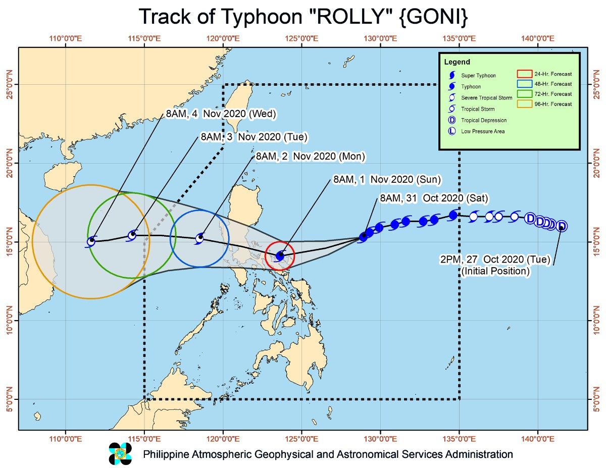
Forecast track
At 10 p.m. on Saturday, the eye of the typhoon was located at 185 kilometers east of Virac, Catanduanes with maximum sustained winds of 215 kilometers per hour near the center and gustiness of up to 265 kph.
It is moving west-southwestward at 25 kph. Rolly is forecast to exit the mainland Luzon landmass on early Monday.
Rolly is forecast to make landfall over Catanduanes on Sunday morning, followed by Camarines Sur, at or near its current peak intensity.
It will then cross the Camarines Provinces and head toward mainland Quezon on Sunday afternoon.
Rolly would exit the mainland Luzon landmass and emerge over the Philippine Sea on Monday morning after it has crossed the CALABARZON area.
Hazards affecting land
From Saturday night to Sunday, the passage of Rolly may bring heavy to intense with, at times, torrential rains over the Bicol Region, CALABARZON, Metro Manila, Marinduque, the northern portion of Mindoro Provinces, Bataan, Bulacan, Aurora, and the eastern portions of mainland Cagayan and Isabela.
Meanwhile, moderate to heavy rains are expected over the Cordillera Administrative Region and the rest of mainland Cagayan Valley and Central Luzon.
“Flooding (including flash floods), rain-induced landslides, and sediment-laden streamflows (i.e. lahar) may occur during heavy or prolonged rainfall especially in areas that are highly or very highly susceptible to these hazards,” PAGASA warned.
According to PAGASA, very destructive typhoon-force winds will prevail in areas under TCWS no. 4 while destructive typhoon-force winds may be experienced over areas under TCWS no. 3.
Areas under TCWS no. 2 may experience damaging gale to storm-force winds while strong breeze to near gale conditions may prevail over areas under TCWS no. 1
In the next 24 hours, there is also a high risk of a storm surge of more than 3 meters over coastal areas of Catanduanes and Camarines Norte as well as the northern coastal areas of Quezon (including Polillo Islands and Camarines Sur).
A storm surge of also up to 3 meters may also occur over the coastal areas of Metro Manila, Cavite, Bulacan, Pampanga, Bataan, the southeastern coastal area of Batangas (facing Tayabas Bay), and most of the southern coastal areas of Quezon.
There is also a high risk of a storm surge of up to 2 meters over the coastal areas of Marinduque, Lubang Island, and Burias Island as well as the remaining coastal areas of Quezon, Camarines Sur, and Batangas.
“This storm surge, which may be accompanied by swells and breaking waves reaching the coast can cause life-threatening and damaging coastal inundation,” PAGASA said.
Hazards affecting the coastal waters
On Saturday, rough to phenomenal seas will prevail over the seaboards of areas where TCWS has been raised.
Meanwhile, rough to very rough seas are expected over the remaining seaboards of Northern Luzon and the eastern seaboards of Eastern Visayas (that are not under TCWS) and Caraga while moderate to rough seas may prevail over the remaining seaboards in the country.
“Mariners of small seacrafts are advised to take precautionary measures when venturing out to sea. Inexperienced mariners should avoid navigating in these conditions,” PAGASA said.
Other system being monitored
At 10 p.m. on Saturday, tropical depression Atsain was estimated outside the Philippine Area of Responsibility (PAR) at 1,405 km east of southern Luzon with maximum sustained winds of 55 kph near the center and gustiness of up to 70 kph.
It is moving west-northwestward at 20 kph and is forecast to enter PAR on Sunday afternoon. It will then be named “Siony.” —MDM/DVM, GMA News
