
Signal No. 3 up over 13 areas as Rolly threatens Batangas, Cavite
Tropical Cyclone Wind Signal No. 3 remained raised over 13 areas across the country as Typhoon Rolly headed for the southeastern coast of Batangas, PAGASA said late Sunday afternoon.
In its 5 p.m. severe weather bulletin, PAGASA said a “particularly dangerous situation” should be expected in Batangas and Cavite.
“Destructive winds and intense rainfall associated with the region of the eyewall and inner rainbands of the typhoon is prevailing or expected within 12 hours over the Batangas and Cavite,” it said.
Signal No. 3 was hoisted over the following areas and residents should expect winds of 121 to 170 kilometers per hour (kph):
- The southern portion of Zambales (San Marcelino, San Narciso, Subic, Olongapo City, Castillejos, San Antonio)
- Bataan
- The southern portion of Pampanga (Floridablanca, Guagua, Minalin, Apalit, Macabebe, Masantol, Sasmuan, Lubao)
- The southern portion of Bulacan (Baliuag, Bustos, Angat, Norzagaray, San Jose del Monte City, Santa Maria, Pandi, Plaridel, Pulilan, Calumpit, Malolos City, Guiguinto, Balagtas, Bocaue, Marilao, Meycauayan City, Obando, Bulacan, Paombong, Hagonoy)
- Rizal
- Quezon including Polillo Islands
- Metro Manila
- Cavite
- Laguna
- Batangas
- Marinduque
- The northwestern portion of Occidental Mindoro (Santa Cruz, Mamburao, Paluan, Abra de Ilog) including Lubang Island
- The northern portion of Oriental Mindoro (Puerto Galera, San Teodoro, Baco, Calapan City, Naujan, Victoria, Naujan Lake, Pola, Socorro)
Signal No. 2 was raised over the following areas, with winds of 61 to 120 kph expected or currently prevailing:
- The rest of Zambales
- The rest of Pampanga
- The rest of Bulacan, the southern portion of Tarlac (Concepcion, Capas, Bamban)
- The rest of Occidental Mindoro, the rest of Oriental Mindoro, and the southern portion of Nueva Ecija (General Tinio, Gapan City, Peñaranda, San Leonardo, Jaen, San Isidro, Cabiao, San Antonio)
Meanwhile, Signal No. 1 was raised over the following areas. PAGASA said winds of 30 to 60 kph should be expected:
- Mainland Cagayan
- Isabela
- Apayao
- Kalinga
- Mountain Province
- Ifugao
- Abra
- Ilocos Norte
- Ilocos Sur
- La Union
- Benguet
- Nueva Vizcaya
- Quirino
- The rest of Aurora
- The rest of Nueva Ecija
- The rest of Tarlac
- Camarines Sur
- Camarines Norte
- Burias Island
- Romblon
- Calamian Islands
Track and forecast positions
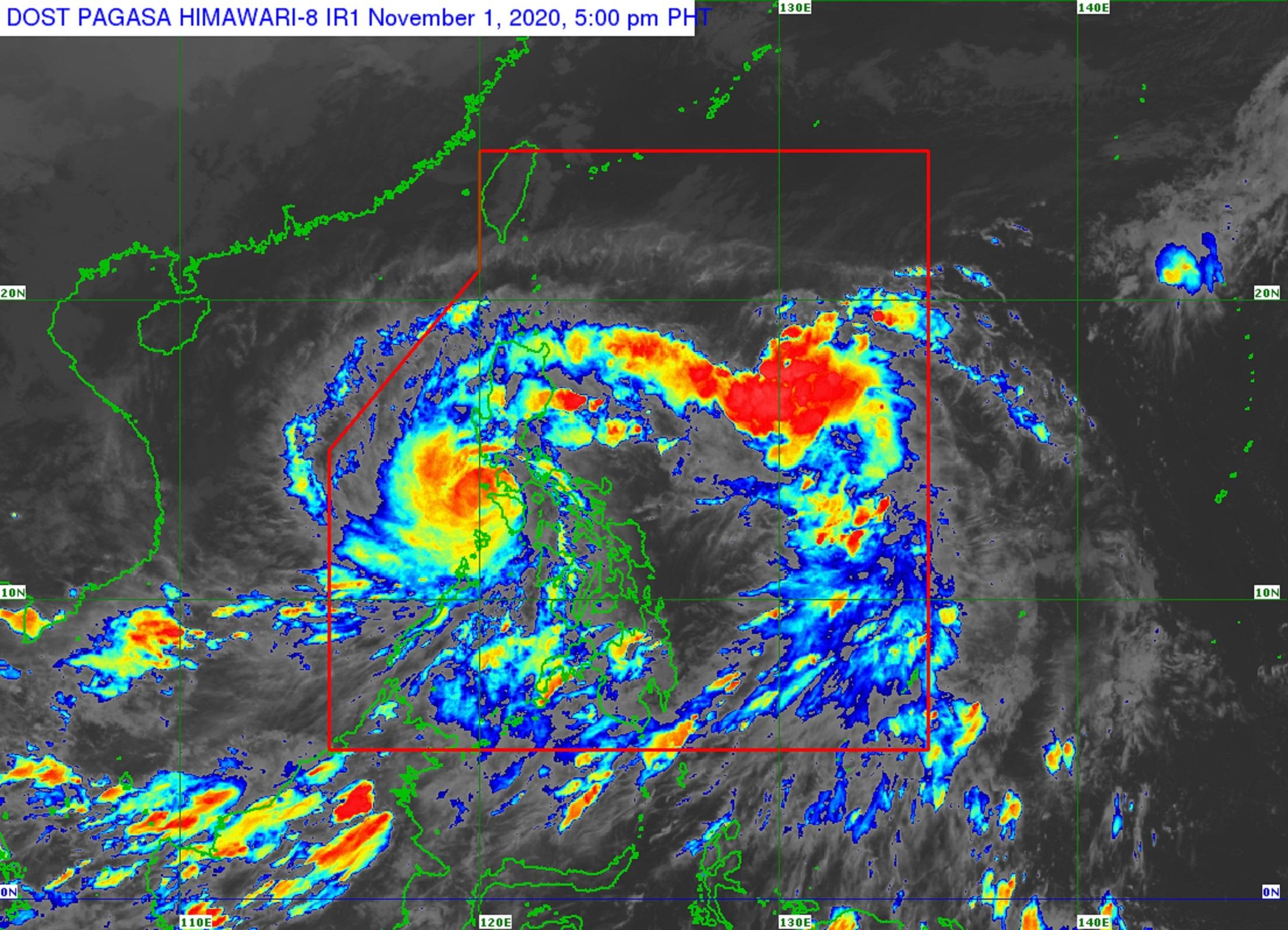
PAGASA said the eye of Rolly was last located 50 kilometers south-southwest of Tayabas, Quezon packing maximum sustained winds of 165 kph and gustiness of up to 230 kph.
The typhoon continues to move westward at 25 kph.
The state weather bureau said Rolly would move toward the Batangas-Cavite area late Sunday afternoon through evening.
Between 5 p.m. and 7 p.m. Sunday, the eye of Rolly will be around 70 kilometers south of Metro Manila.
The typhoon is still expected to exit the mainland Luzon landmass and emerge over the West Philippine Sea on Sunday night.
By Monday afternoon, Rolly is expected to be 300 kilometers west of Iba, Zambales.
By Tuesday afternoon, it will be outside the Philippine Area of Responsibility or 665 kilometers west of Iba, Zambales.
Hazards
PAGASA said Rolly will bring heavy to at times intense rain over CALABARZON, Metro Manila, Marinduque, Romblon, the Mindoro Provinces, Bataan, Bulacan, Aurora, and the eastern portions of mainland Cagayan and Isabela.
Moderate to heavy rain will prevail over the Cordillera Administrative Region, and the rest of mainland Cagayan Valley and Central Luzon.
Light to moderate with at times heavy rain should be expected over the Zamboanga Peninsula, Bangsamoro, Western Visayas, and the rest of Luzon.
PAGASA also said that “destructive typhoon-force winds” will prevail in areas under Signal No. 3, damaging gale- to storm-force winds in areas under Signal No. 2, and a strong breeze to near gale conditions in areas under Signal No. 1.
The weather bureau also warned that there was a high risk of a 3-meter high storm surge over the northern coastal areas of Quezon including Polillo Island, coastal areas of Metro Manila, Cavite, Bulacan, Pampanga, Bataan, the southeastern coastal area of Batangas (facing Tayabas Bay), and most of the southern coastal areas of Quezon.
A storm surge of up to 2 meters may also occur over the coastal areas of Marinduque, Lubang Island, Albay, Masbate (including Ticao and Burias Islands), the northern coastal area of Mindoro Provinces, and the remaining coastal areas of Quezon, and Batangas.
PAGASA added that there was a moderate to high risk of a seiche or storm surge over the coastal areas surrounding Laguna de Bay and Taal Lake.
“These storm surges, which may be accompanied by swells and breaking waves reaching the coast can cause life-threatening and damaging coastal inundation,” it said.
Coastal waters
PAGASA said rough to phenomenal seas (2.5 to 16 meters) will be experienced in areas where a storm signal was raised.
Rough to very rough seas (2.5 to 5.0 meters) will also prevail over the remaining seaboards of Northern Luzon and the eastern seaboards of Eastern Visayas that are not under a storm signal, while moderate to rough seas (1.2 to 2.5 meters) will be experienced over remaining seaboards of the country. — DVM, GMA News
