

Signal No. 1 up over 18 areas as Tonyo moves toward Marinduque, Mindoro
Tropical Cyclone Wind Signal No. 1 was raised over 18 areas early Sunday as Tropical Depression Tonyo moved toward Marinduque and the Mindoro Provinces, PAGASA said in its 5 a.m. severe weather bulletin.
The areas under TCWS No. 1 are:
- Camarines Norte
- Camarines Sur
- the western portion of Albay (Polangui, Oas, Ligao City, Pio Duran, Libon)
- the western portion of Masbate (Aroroy, Mandaon, Balud) including Burias Island
- Quezon including Polillo Islands
- Cavite
- Laguna
- Rizal
- Batangas
- Metro Manila
- Bataan
- Marinduque
- Romblon
- Oriental Mindoro
- Occidental Mindoro including Lubang Island
- Calamian Islands
- the northwestern portion of Aklan (Buruanga, Ibajay, Tangalan, Makato, Numancia, Nabas, Malay)
- the northern portion of Antique (Pandan, Libertad, Caluya)
These areas will have 30-60 km/h winds prevailing or expected in 36 hours.
Rainfall
Moderate to heavy rains will pour over Mindoro Provinces, the northern portion of Quezon including Polillo Islands, Aurora, and the eastern portions of mainland Cagayan and Isabela.
Light to moderate to at times heavy rains meanwhile will be felt over the Ilocos Region, Cordillera Administrative Region, Metro Manila, and the rest of Central Luzon, Calabarzon, and MIMAROPA.
PAGASA warned of flooding and landslides that may occur during times of heavy or prolonged rainfall in areas susceptible to these hazards.
Winds
Strong breeze to near gale conditions with occasional gusts are to be expected in areas under TCWS No. 1 throughout Tonyo's passage.
Meanwhile, strong breeze to near gale conditions will also prevail over Batanes, Babuyan Islands, Ilocos Norte, Apayao, and the northern portion of mainland Cagayan due to the Northeast Monsoon (Amihan).
Location
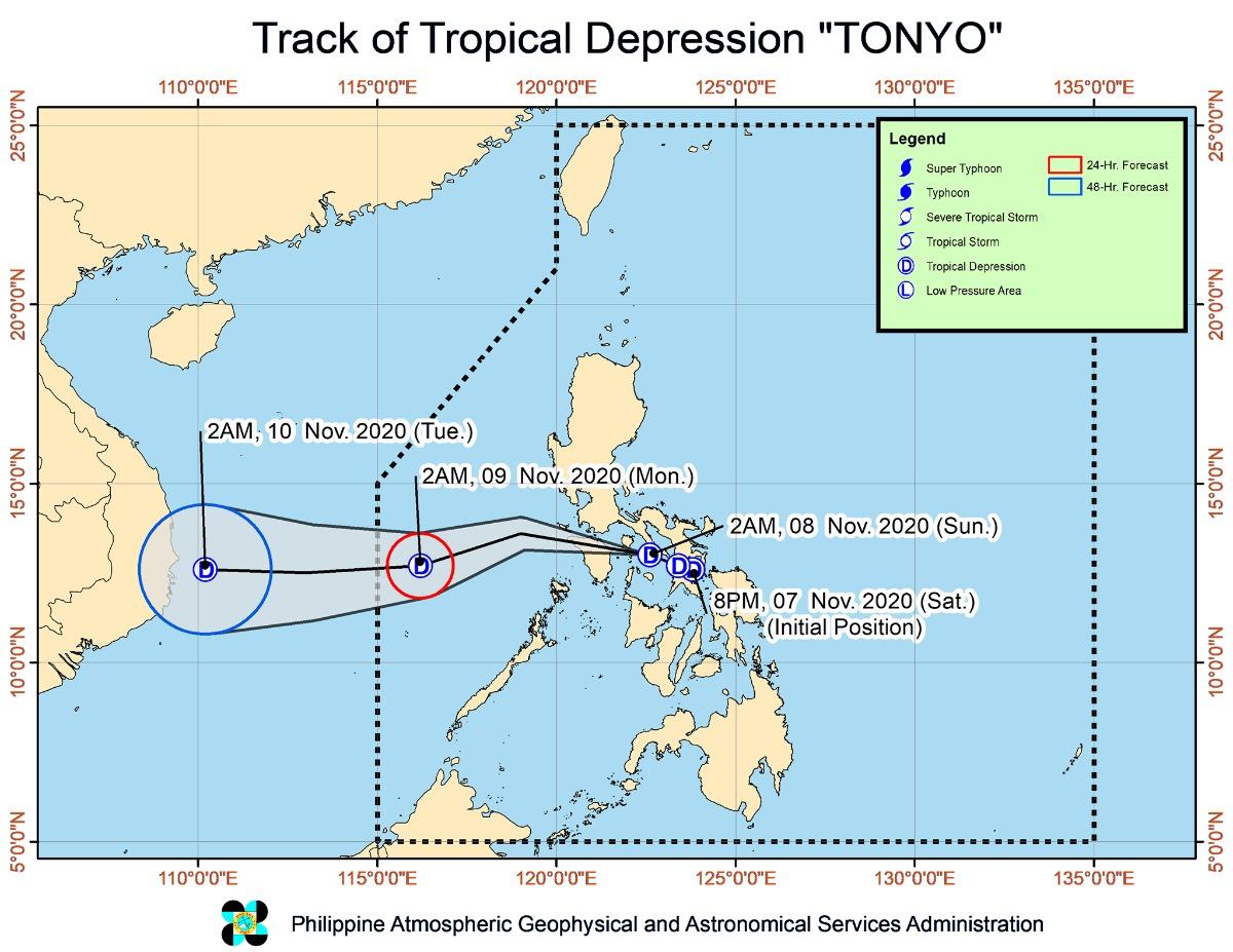
At 5 a.m., Tonyo was about to cross Marinduque.
The center of Tonyo was located at 4 a.m. Sunday at 90 km south southeast of Alabat, Quezon.
Tonyo has maximum sustained winds of 45 km/h near the center and gustiness of up to 60 km/h.
It is moving west northwestward at 25 km/h.
Track
Tonyo's center is expected to pass close or over the vicinity of Marinduque and Mindoro Provinces, PAGASA said.
However, there is an increasing likelihood that the eye will make landfall in the vicinity of Southern Quezon or Batangas.
Tonyo is expected to move rapidly west northwestward or westward in the next 12 hours.
It is also forecast to emerge over the West Philippine Sea on Sunday morning and exit the Philippine Area of Responsibility on Monday morning.
Coastal waters
Seaboards of areas under TCWS No. 1, as well as the eastern seaboards of Cagayan Valley, Aurora, and the northern portion of Quezon, and the northern and eastern seaboards of Catanduanes will have moderate to rough seas, with waves reaching up to 3.5 meters due to Tonyo and the easterlies.
Those with small seacraft are advised to take the necessary precautions when venturing out to sea. PAGASA advised inexperienced mariners to avoid navigating.
Meanwhile, the seaboards of Batanes, Ilocos Norte, and Ilocos Sur and the northern seaboard of Cagayan including Babuyan Islands will have rough to very rough seas (with waves up to 3.5 meters) due to the Northeast Monsoon (Amihan). PAGASA said sea travel is risky in these areas, especially for those with small seacraft.
The weather bureau advised the public and disaster risk reduction and management councils concerned to take the necessary precautions and await the next weather bulletin to be issued at 8 a.m. —KG, GMA News
