

Signal No. 1 up over 21 areas, Vicky now over Bohol Sea
Tropical Cyclone Wind Signal (TCWS) No. 1 remained over 21 areas as tropical depression Vicky is now over Bohol Sea after emerging offshore from the coast of Misamis Oriental, PAGASA announced late Friday evening.
In its 11 p.m. Severe Weather Bulletin, the weather agency said there is a possibility that Vicky may make another landfall over the Siquijor-Negros Oriental area or Misamis Occidental-Zamboanga del Norte area before reaching Sulu Sea.
TCWS No. 1 is now hoisted over the following areas:
- The northern and central portions of Palawan (Araceli, Dumaran, Taytay, El Nido, San Vicente, Roxas, Puerto Princesa City, Aborlan, Narra, Quezon) including Calamian, Cuyo, Cagayancillo, and Kalayaan Islands
- The central and southern portions of Cebu (Tuburan, Carmen, Asturias, Danao City, Compostela, Liloan, Consolacion, Mandaue City, Lapu-Lapu City, Cordoba, Balamban, Cebu City, Talisay City, Minglanilla, Toledo City, Pinamungahan, Naga City, San Fernando, Aloguinsan, Carcar, Barili, Sibonga, Dumanjug, Ronda, Alcantara, Moalboal, Argao, Dalaguete, Badian, Alegria, Alcoy, Boljoon, Oslob, Malabuyoc, Ginatilan, Samboan, Santander)
- Bohol
- Siquijor
- Negros Oriental
- Negros Occidental
- Guimaras
- the central and southern portions of Iloilo (Ajuy, Barotac Viejo, San Enrique, San Rafael, Passi City, Bingawan, Calinog, Lambunao, Janiuay, Banate, Anilao, Dingle, Duenas, Badiangan, Barotac Nuevo, Zarraga, Pototan, Dumangas, Mina, New Lucena, Santa Barbara, Leganes, Iloilo City, Pavia, Cabatuan, Maasin, Alimodian, San Miguel, Leon, Oton, Tigbauan, Tubungan, Guimbal, Igbaras, Miagao, San Joaquin)
- the southern portion of Antique (Valderrama, San Remigio, Sibalom, Hamtic, Tobias Fornier, Anini-Y, Bugasong, Laua-An, Patnongon, San Jose, Belison)
- Misamis Oriental
- Misamis Occidental
- Lanao del Norte
- Bukidnon
- Camiguin
- Lanao del Sur
- the northwestern portion of North Cotabato (Pigkawayan, Libungan, Banisilan, Carmen, Midsayap, Aleosan, Alamada)
- the northern portion of Maguindanao (Datu Odin Sinsuat, Kabuntalan, Northern Kabuntalan, Sultan Kudarat, Sultan Mastura, Parang, Matanog, Barira, Buldon)
- Cotabato City
- the northern and central portions of Zamboanga del Norte (Siocon, Baliguian, Gutalac, Kalawit, Labason, Tampilisan, Liloy, Godod, Bacungan, Salug, Sindangan, Siayan, Manukan, Jose Dalman, Sergio Osmena Sr., Pres. Manuel A. Roxas, Katipunan, Dipolog City, Pinan, Mutia, La Libertad, Polanco, Rizal, Sibutad, Dapitan City)
- Zamboanga del Sur
- Zamboanga Sibugay
PAGASA said areas under TCWS No. 1 may experience strong breeze to near gale conditions during the passage of Vicky.
“However, it must be noted that gusty conditions are likely over most of Luzon and Visayas that are not under TCWS… due to the surge of the Northeast Monsoon,” it said.
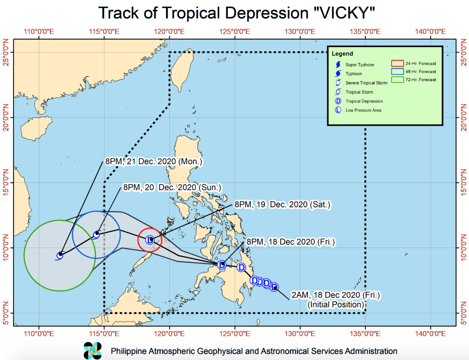
As of 10 p.m. on Friday, the center of Vicky was estimated at 75 kilometers west-northwest of El Salvador City, Misamis Oriental or at 75 km east of Dipolog City, Zamboanga with maximum sustained winds of 45 kilometers per hour near the center and gustiness of up. to 70 kph.
Vicky is moving west-northwestward at 40 kph toward the Sulu Sea.
From Saturday afternoon or evening, Vicky is forecast to cross the northern or central portion of Palawan. It may exit the Philippine Area of Responsibility on Sunday afternoon or evening.
Hazards affecting land
From Friday night to Saturday evening, heavy to intense rains are expected over Eastern Visayas.
Meanwhile, moderate to heavy with, at times, intense rains may prevail over the southern portion of Quezon, Bicol Region, Dinagat Islands, Surigao del Norte, Agusan del Norte, Camiguin, the northern and central portions of Palawan including Calamian, Cuyo, and Cagayancillo Islands, and the rest of Visayas.
The rest of Caraga, the rest of Northern Mindanao, Zamboanga Peninsula, Oriental Mindoro, the rest of Quezon, Aurora, mainland Cagayan Valley, Apayao, Kalinga, Mountain Province, and Ifugao may also experience light to moderate with, at times, heavy rains.
Between Saturday evening and Sunday night, PAGASA said heavy to intense rains may prevail over the Bicol Region.
Moderate to heavy with, at times, intense rains may also prevail over Quezon, mainland Cagayan Valley, Apayao, Kalinga, Mountain Province, Ifugao, the northern and central portion of Palawan including Calamian and Kalayaan Islands, Oriental Mindoro, and Eastern Visayas.
Meanwhile, light to moderate with, at times, heavy rains are expected over Antique, Aklan, and the rest of CALABARZON and MIMAROPA.
“Flooding (including flash floods) and rain-induced landslides may occur during heavy or prolonged periods of rainfall,” PAGASA said.
Hazards affecting coastal waters
According to PAGASA, rough to very rough seas are expected over the following seaboards in the next 24 hours:
- the entire seaboards of Northern Luzon
- the seaboard of Aurora
- the eastern seaboard of Quezon including Polillo Islands
- the seaboard of Camarines Norte
- the northern seaboard of Camarines Sur
- the northern and eastern seaboards of Catanduanes
- the eastern seaboard of Albay including Rapu-Rapu Islands
- the eastern seaboard of Sorsogon
- the northern and eastern seaboards of Northern Samar
- the eastern seaboard of Eastern Samar including Homonhon Island
- the eastern seaboard of Dinagat Islands
- the eastern seaboard of Surigao del Norte
- the seaboard of Surigao del Sur
- the eastern seaboard of Davao Oriental
The weather agency warned that sea travel is risky.
Meanwhile, moderate to rough seas are expected over areas under TCWS No. 1, the seaboard of Agusan del Norte, and the remaining seaboards of Surigao del Norte and DInagat Islands. -- BAP, GMA News
