

Vicky moves over Bohol Sea, heavy rains expected over Palawan, most of the Visayas, northern Mindanao
Tropical Depression Vicky continues to move westward over Bohol Sea, PAGASA reported in the latest Severe Weather Bulletin early Saturday morning.
The combined effects of Tropical Depression Vicky and Tail-End of a Frontal System (Shear Line) will bring heavy rains over Palawan, most of Visayas and parts of northern Mindanao.
Hazards affecting land areas
The areas under Tropical Cyclone Wind Signal (TCWS) No. 1) will have strong breeze to near gale conditions during the passage of the tropical cyclone. However, it must be noted that gusty conditions are likely over most of Luzon and Visayas that are not under TCWS (especially in coastal and mountainous areas) due to the surge of the Northeast Monsoon.
The combined effects of Tropical Depression VICKY and Tail-End of a Frontal System (Shear Line) will bring:
On Saturday, heavy to intense rains is expected over Eastern Visayas.
Moderate to heavy with at times intense rains over Quezon, Aurora, Bicol Region, Dinagat Islands, Surigao del Norte, Agusan del Norte, Camiguin, the northern and central portions of Palawan including Calamian, Cuyo, and Cagayancillo Islands, and the rest of Visayas.
Light to moderate with at times heavy rains over Metro Manila, Zamboanga Peninsula, mainland Cagayan Valley, Apayao, Kalinga, Mountain Province, Ifugao, and the rest of Caraga, Northern Mindanao, CALABARZON, and MIMAROPA.
Tropical Cyclone Wind Signal (TCWS) No. 1 is hoisted over the following areas:
Luzon
- The northern and central portions of Palawan (Araceli, Dumaran, Taytay, El Nido, San Vicente, Roxas, Puerto Princesa City, Aborlan, Narra, Quezon) including Calamian, Cuyo, Cagayancillo, and Kalayaan Islands
Visayas
- The central and southern portions of Cebu (Asturias, Danao City, Compostela, Liloan, Consolacion, Mandaue City, Lapu-Lapu City, Cordoba, Balamban, Cebu City, Talisay City, Minglanilla, Toledo City, Pinamungahan, Naga City, San Fernando, Aloguinsan, Barili, Carcar, Sibonga, Ronda, Dumanjug, Alcantara, Argao, Moalboal, Badian, Dalaguete, Alcoy, Alegria, Malabuyoc, Oslob, Ginatilan, Boljoon, Samboan, Santander),
- Bohol
- Siquijor
- Negros Oriental
- Negros Occidental
- Guimaras
- the central and southern portions of Iloilo (Ajuy, Barotac Viejo, San Enrique, San Rafael, Passi City, Bingawan, Calinog, Lambunao, Janiuay, Banate, Anilao, Dingle, Duenas, Badiangan, Barotac Nuevo, Zarraga, Pototan, Dumangas, Mina, New Lucena, Santa Barbara, Leganes, Iloilo City, Pavia, Cabatuan, Maasin, Alimodian, San Miguel, Leon, Oton, Tigbauan, Tubungan, Guimbal, Igbaras, Miagao, San Joaquin)
- the southern portion of Antique (Valderrama, San Remigio, Sibalom, Hamtic, Tobias Fornier, Anini-Y, Bugasong, Laua-An, Patnongon, San Jose, Belison)
Mindanao
- The western portion of Misamis Oriental (Kinoguitan, Binuangan, Sugbongcogon, Salay, Lagonglong, Balingasag, Jasaan, Villanueva, Tagoloan, Cagayan de Oro City, Opol, El Salvador City, Alubijid, Laguindingan, Gitagum, Libertad, Initao, Naawan, Manticao, Lugait)
- the northwestern portion of Bukidnon (Libona, Baungon, Talakag)
- Camiguin
- Misamis Occidental
- the northern portion of Lanao del Sur (Bubong, Tagoloan II, Kapai, Buadiposo-Buntong, Mulondo, Ditsaan-Ramain, Marawi City, Saguiaran, Marantao, Piagapo, Taraka, Tamparan, Poona Bayabao, Masiu, Lumbayanague, Lumbatan, Lumbaca Unayan, Bayang, Binidayan, Pagayawan, Ganassi, Tubaran, Picong, Calanogas, Pualas, Madamba, Madalum, Bacolod Kalawi, Tugaya, Balindong)
- Lanao del Norte
- the northern and central portions of Zamboanga del Norte (Siocon, Baliguian, Gutalac, Kalawit, Labason, Tampilisan, Liloy, Godod, Bacungan, Salug, Sindangan, Siayan, Manukan, Jose Dalman, Sergio Osmena Sr., Pres. Manuel A. Roxas, Katipunan, Dipolog City, Pinan, Mutia, La Libertad, Polanco, Rizal, Sibutad, Dapitan City)
- Zamboanga del Sur
- Zamboanga Sibugay
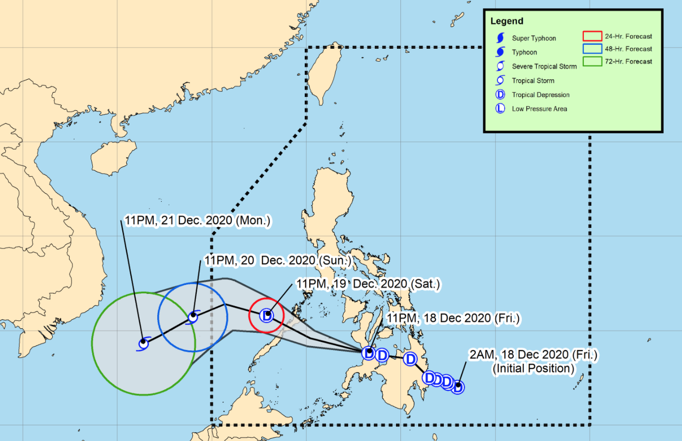
Tropical Depression Vicky is forecast to move generally west-northwestward towards Sulu Sea.
However, there remains the possibility of landfall over the Siquijor-Negros Oriental area or the Misamis Occidental-Zamboanga del Norte area before reaching the Sulu Sea.
Vicky is forecast to cross the northern or central portion of Palawan between afternoon or evening on Saturday and is likely to exit the Philippine Area of Responsibility (PAR) by Sunday afternoon or evening.
Vicky is forecast to remain a tropical depression while crossing the Philippine archipelago and the may gain strength once it reaches the West Philippine Sea.
As of 1 a.m. on Saturday, the center of Tropical Depression Vicky was estimated at 30 kilometers north northwest of Dipolog City, Zamboanga del Norte with maximum sustained winds of 45 kilometers per hour near the center and gustiness of up to 70 kph as it continues to move in the west northwest direction at 30kph.
On Sunday, heavy to intense rains over Bicol Region.
Moderate to heavy with at times intense rains over Quezon, Aurora, mainland Cagayan Valley, Apayao, Kalinga, Mountain Province, Ifugao, the northern and central portion of Palawan including Calamian and Kalayaan Islands, Oriental Mindoro, and Eastern Visayas. Light to moderate with at times heavy rains over Antique, Aklan, Metro Manila, and the rest of CALABARZON and MIMAROPA
Flooding (including flash floods) and rain-induced landslides may occur during heavy or prolonged periods of rainfall, especially in areas identified to be highly or very highly susceptible to these hazards and in localities that received significant antecedent rainfall over the past couple of days or weeks.
Adjacent or nearby areas may also experience flooding in the absence of such rainfall occurrence due to surface runoff or swelling of river channels.
Hazards affecting coastal waters
In the next 24 hours, the combined effects of the surge of the northeast monsoon and the tropical depression will bring rough to very rough seas over the entire seaboards of Northern Luzon, the seaboard of Aurora, the eastern seaboard of Quezon including Polillo Islands, the seaboard of Camarines Norte, the northern seaboard of Camarines Sur, the northern and eastern seaboards of Catanduanes, the eastern seaboard of Albay including Rapu-Rapu Islands, the eastern seaboard of Sorsogon, the northern and eastern seaboards of Northern Samar, the eastern seaboard of Eastern Samar including Homonhon Island, the eastern seaboard of Dinagat Islands, the eastern seaboard of Surigao del Norte, the seaboard of Surigao del Sur, and the eastern seaboard of Davao Oriental.
Sea travel is risky over these waters especially for small sea vessels.
Moderate to rough seas (2.0 to 4.0 m) will be experienced over the coastal waters of areas under TCWS No. 1, the seaboard of Misamis Oriental not under TCWS, the seaboard of Agusan del Norte, and the remaining seaboards of MIMAROPA, Bicol Region, Visayas, Surigao del Norte, and Dinagat Islands. Sea travel is risky over these waters especially for small sea vessels. -- BAP, GMA News
