
Signal No. 1 raised over 14 areas as Bising further intensifies
Typhoon Bising continues to rapidly intensify while moving in the west-northwest direction over the Philippine Sea, according to the Severe Weather Bulletin posted by PAGASA early Saturday morning.
Eastern Visayas, Caraga, and Davao Region will have cloudy skies with scattered rainshowers and thunderstorms brought about by the typhoon with possible flash floods or landslides during moderate to heavy rains.
Metro Manila and the rest of the country, meanwhile, will be partly cloudy to cloudy skies with isolated rainshowers due to localized thunderstorms with possible flash floods or landslides during severe thunderstorms.
Tropical Cyclone Wind Signal (TCWS) No. 1 is hoisted over the following areas:
- Central and eastern portions of Sorsogon (Castilla, Magallanes, Matnog, Juban, Irosin, Bulan, Santa Magdalena, Bulusan, Barcelona, Casiguran, Gubat, Prieto Diaz, Sorsogon City)
- the eastern portion of Albay (Manito, Legazpi City, Santo Domingo, Malilipot, Bacacay, Tabaco City, Rapu-Rapu, Malinaw, Tiwi)
- the eastern portion of Camarines Sur (Presentacion, Caramoan, Garchitorena)
- Catanduanes
- Northern Samar
- Samar
- Eastern Samar
- Biliran
- Leyte
- Southern Leyte
- Camotes Islands, Cebu
- Dinagat Islands
- Surigao del Norte (including Siargao and Bucas Grande Islands)
- Surigao del Sur
Rough to very rough seas will be experienced over the eastern seaboards of Bicol Region, Eastern Visayas, Caraga and Davao Region.
Sea travel for all types of seacrafts is risky over these waters.
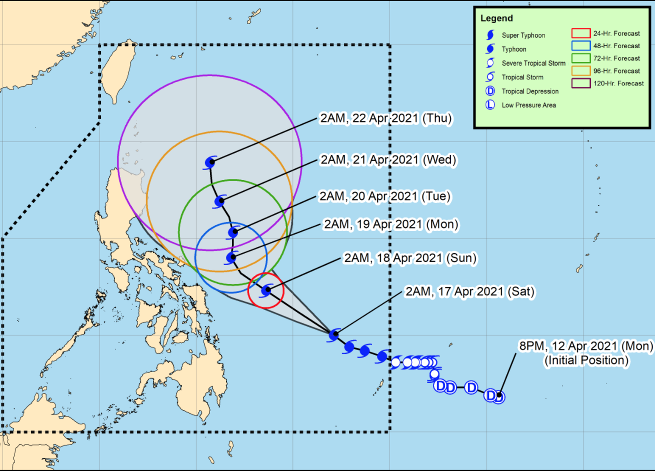
As of 4 a.m., the center of the eye of Typhoon Bising was located at 705 kilometers east of Surigao City, Surigao del Norte or 775 kilometers east of Maasin City, Southern Leyte and moving in the west northwest direction at 20 kph with maximum sustained winds of 175 kph near the center and gustiness of up to 215 kph.
With favorable atmospheric and oceanic conditions, Bising has rapidly intensified over the past 24 hours and is forecast to further intensify and reach its peak intensity, from 195 to 205 kph, tomorrow.
Forecast
On Sunday, the rainbands of Typhoon Bising will bring moderate to heavy with at times intense rains over Eastern Visayas, Sorsogon, Masbate, Albay, Camarines Sur, Catanduanes, and Camotes Islands.
Flooding, including flashfloods, and rain-induced landslides may occur especially in areas identified in hazard maps as highly or very highly susceptible to these hazards.
Tropical cyclone winds of at least strong breeze to near gale in strength extend outward up to 550 km from the center of the typhoon.
Destructive typhoon-force winds extend outward up to 50 km from the center of the typhoon.
Track and Intensity Outlook
Bising will move generally west-northwestward or northwestward over the Philippine Sea until Sunday afternoon or evening then slow down and move northward or north-northeastward until early morning Tuesday before moving north-northwestward over the Philippine Sea east of Northern and Central Luzon. -- BAP, GMA News
