

Signal No. 2 still up over 10 areas as Dante heads towards Bataan-Zambales area
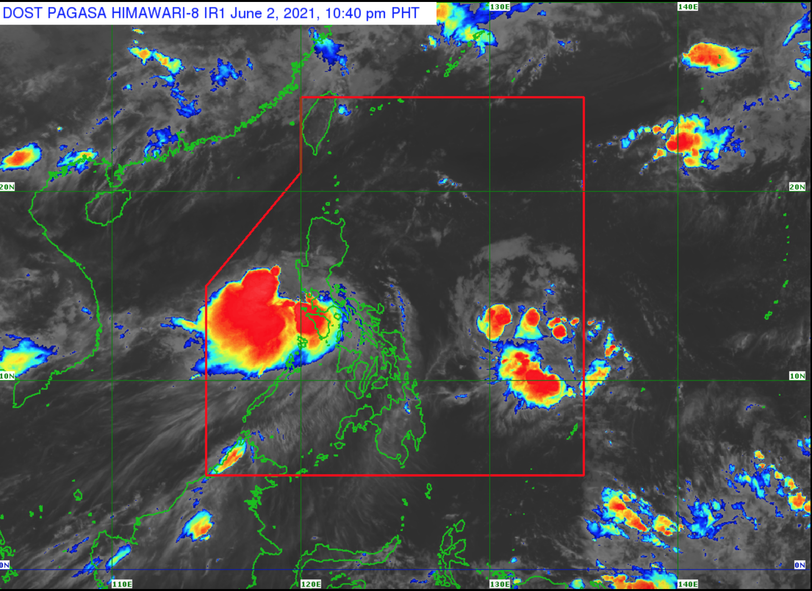
Tropical Cyclone Wind Signal No. 2 remained hoisted over 10 areas in Luzon as Tropical Storm Dante crossed the southwestern portion of Batangas and is now heading towards the Bataan Peninsula-Southern Zambales area, PAGASA said Wednesday night.
In its 11 p.m. Severe Weather Bulletin, the weather agency said the center of Dante was located over the coastal waters of Nasugbu, Batangas with maximum sustained winds of 65 kilometers per hour near the center and gustiness up to 90 kph and central pressure of 98 hPa. It is moving northwestward at 15 kph.
TCWS No. 2 is up over the following areas:
- the extreme northern portion Oriental Mindoro (Puerto Galera)
- the extreme northern portion Occidental Mindoro (Paluan, Lubang Islands, Abra de Ilog) including Lubang Islands
- Batangas
- Cavite
- Bataan
- the southwestern portion of Bulacan (Calumpit, Bulacan, City of Malolos, Paombong, Hagonoy)
- the western portion of Pampanga (Masantol, Macabebe, Sasmuan, Lubao, Floridablanca, Porac, Guagua, Santa Rita, Angeles City, Mabalacat City, Minalin, Bacolor)
- Zambales
- the western portion of Tarlac (Bamban, Capas, San Jose, Mayantoc, Camiling, Santa Ignacia, San Clemente)
- the western portion of Pangasinan (Bolinao, Anda, Bani, Agno, Burgos, Infanta, Dasol, City of Alaminos, Mabini, Sual, Labrador, Bugallon, Aguilar, Mangatarem, Bayambang, Urbiztondo, Basista, Malasiqui, San Carlos City, Santa Barbara, Mangaldan, Dagupan City, Calasiao, Binmaley, Lingayen)
Meanwhile, TCWS No. 1 is raised over the following:
- the rest of the northern portion of Oriental Mindoro (Bansud, Gloria, Pola, Pinamalayan, Socorro, Victoria, Naujan, Baco, City of Calapan, San Teodoro)
- the rest of the northern portion of Occidental Mindoro (Sablayan, Calintaan, Mamburao, Santa Cruz)
- the western portion of Quezon (San Antonio, Tiaong, Candelaria, Sariaya, Dolores, Lucban, City of Tayabas, Lucena City, Sampaloc)
- Laguna
- Metro Manila
- Rizal
- the rest of Bulacan
- the rest of Pampanga
- the rest of Tarlac
- the western portion of Nueva Ecija (Science City of Muñoz, Lupao, Cuyapo, Talugtug, Guimba, Nampicuan, Quezon, Licab, Santo Domingo, Talavera, Cabanatuan City, Santa Rosa, Aliaga, Zaragoza, Jaen, San Antonio, Cabiao, San Isidro, San Leonardo, City of Gapan, Peñaranda)
- the rest of Pangasinan, the southern portion of Benguet (Itogon, Tuba, Sablan, Baguio City, La Trinidad, Kapangan, Tublay)
- La Union
The PAGASA said Dante is forecasted to turn and maintain a north northwestward path and may likely make another landfall in Bataan Peninsula or the southern tip of Zambales in the next three to six hours.
Dante is forecasted to emerge over the West Philippine Sea off the western coast of Pangasinan on Thursday morning, PAGASA added.
It is forecasted to eventually weaken into a tropical depression by Thursday evening.
Hazards
From Wednesday night to Thursday evening, Dante will bring moderate to heavy with, at times, intense rains over the northern portion of Occidental Mindoro including Lubang Islands, the northern portion of Oriental Mindoro, Batangas, Cavite, Bataan, Zambales, and Pangasinan.
Meanwhile, light to moderate with, at times, heavy rains will prevail over Cordillera Administrative Region, Metro Manila, Calamian Islands, Romblon, Marinduque, and rest of Ilocos Region, Central Luzon, CALABARZON, Occidental Mindoro, and Oriental Mindoro.
PAGASA advised affected residents to prepare for flooding including flash floods and rain-induced landslides.
Strong to gale-force winds are possible over areas under TCWS No. 2, while strong winds may be experienced in areas under TCWS No. 1.
Further, in the next 24 hours, PAGASA said rough to very rough seas (2.4 to 4.0 meters) will prevail over the seaboards of areas under TCWS No. 2.
Moderate to rough seas (1.2 to 3.0 m) will be experienced over the seaboard of areas under TCWS No. 1, the remaining seaboards of Northern Luzon, the eastern seaboard of Central Luzon, seaboard of Quezon including Polillo Islands, the remaining seaboards of Mindoro Provinces, the seaboard of Marinduque, and the western seaboard of Romblon.
"Mariners of small seacrafts are advised to take precautionary measures when venturing out to sea. Inexperienced mariners should avoid navigating in these conditions," PAGASA warned. -- BAP, GMA News
