
Fabian maintains strength, direction; southwest monsoon to bring rains over most of Luzon
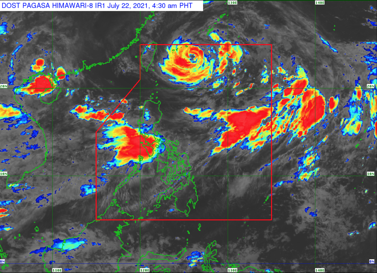
Typhoon Fabian maintains its strength as it moves west southwestward over the sea southeast of Miyako islands, according to the Severe Weather Bulletin posted by PAGASA early Thursday morning.
As of 4 a.m., the center of the eye of Typhoon Fabian was estimated at 530 kilometers northeast of Itbayat, Batanes with maximum sustained winds of 150 kilometers per hour near the center, gustiness of up to 185 kph, and central pressure of 955 hPa and moving west southwestward at 10 kph.
Strong winds or higher extend outwards up to 640 km from the center.
Tropical Cyclone Wind Signal (TCWS) No. 1 is hoisted over Batanes and Babuyan Islands.
Fabian is unlikely to directly bring heavy rainfall in the country throughout the forecast period.
The southwest monsoon is enhanced by Fabian bringing monsoon rains will be experienced in the next 24 hours over Ilocos Region, Abra, Benguet, Zambales, Bataan, Tarlac, Pampanga, Bulacan, Metro Manila, Cavite, Batangas, Occidental Mindoro, Oriental Mindoro, Romblon, and the northern portion of Palawan including Calamian and Kalayaan Islands.
Batanes and Babuyan Islands will experience rains with gusty winds brought about by Fabian with possible flash floods or landslides due to moderate to at times heavy rains. There is also the possibility that very light to light to damage to structures and vegetation may occur due to moderate to strong winds.
Metro Manila, Ilocos Region, MIMAROPA, Benguet, Abra, Zambales, Bataan, Tarlac, Pampanga, Bulacan, Cavite, and Batangas will experience monsoon rains due to the southwest monsoon with possible flash floods or landslides due to scattered to widespread moderate to at times heavy rains.
Western Visayas and the rest of Luzon will have cloudy skies with scattered rainshowers and thunderstorms due to the southwest monsoon with possible flash floods or landslides during moderate to at times heavy rains.
The rest of country will have partly cloudy to cloudy skies with rainshowers or thunderstorms also due to the southwest monsoon with possible flash floods or landslides during severe thunderstorms.
Severe Winds
Strong winds will be experienced over Batanes and Babuyan Islands throughout the passage the typhoon.
In the next 24 hours rough to very rough seas will be experienced over the northern, western, and eastern seaboards of Luzon, including the areas under TCWS No. 1.
Sea travel is risky for small seacrafts over these waters. Mariners without the proper experience should immediately seek safe harbor.
The typhoon will pass close or make landfall in the vicinity of Miyako, Yaeyama, and Senkaku Islands in the southern Ryukyu Archipelago on Friday and forecast to exit the Philippine Area of Responsibility tomorrow evening or Saturday morning.
Forecast Wind and Coastal Water Condition
Luzon and Visayas will experience moderate to strong wind speed moving southwestward while coastal waters will be moderate to strong.
Mindanao will experience light to moderate moving southwestward while coastal waters will be slight to moderate.
The sun will rise by 5:37 a.m. and set by 6:28 p.m. -- BAP, GMA News
