
15 areas, including NCR, under Signal No. 2 as Jolina maintains west northwest direction
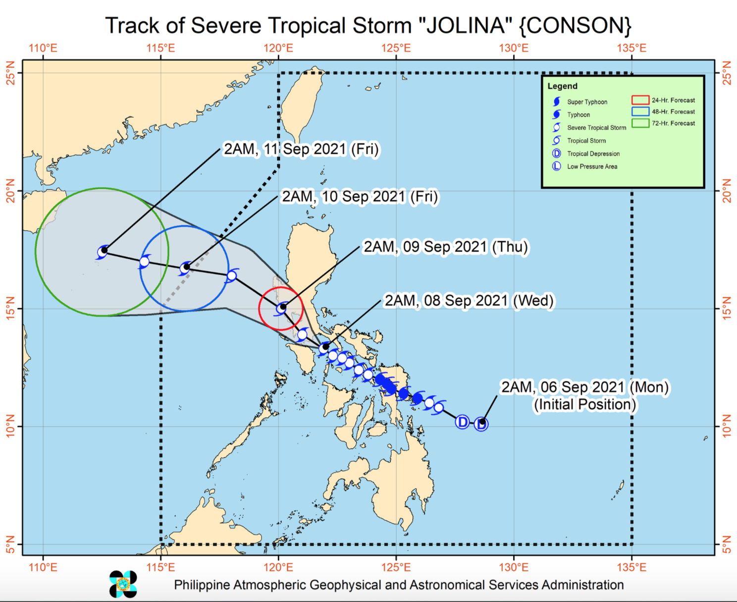
Severe Tropical Storm Jolina is now moving over the Tayabas Bay-Verde Island passage area, according to the latest Severe Weather Bulletin posted by PAGASA.
Metro Manila, CALABARZON, Romblon, Marinduque, and Mindoro provinces will experience stormy weather brought about by Jolina with possible flash floods or landslides due to moderate to heavy rains and possible light to moderate damage to structures and vegetation due to moderate to strong winds.
Central Luzon, La Union, Pangasinan, and Camarines provinces will have rains with gusty winds also due to Jolina with possible flash floods or landslides due to moderate to heavy rains and cause possible very light to light damage to structures and vegetation due to moderate to strong winds.
The rest of Luzon, Western Visayas, Zamboanga Peninsula, Basilan, Sulu, and Tawi-Tawi Cloudy skies with scattered rainshowers and thunderstorms due to Jolina / southwest monsoon with possible flash floods or landslides due to light to moderate with at times heavy rains.
The rest of the country Partly cloudy to cloudy skies with isolated rainshowers or thunderstorms also due to Jolina / southwest monsoon.
Tropical Wind Cyclone Signal (TCWS) No. 2 is raised over the following areas:
- the northern portion of Romblon (Banton, Corcuera, Concepcion, Calatrava, San Andres, San Agustin, Romblon)
- Marinduque
- the northern and central portions of Oriental Mindoro (Bansud, Gloria, Pinamalayan, Pola, Socorro, Victoria, Puerto Galera, San Teodoro, Baco, City of Calapan, Naujan)
- the northern and central portions of Occidental Mindoro (Abra de Ilog, Paluan, Mamburao, Santa Cruz, Sablayan) including Lubang Islands
- the central and southern portions of Quezon (Buenavista, Mulanay, San Narciso, San Francisco, San Andres, Catanauan, General Luna, Lopez, Macalelon, Sampaloc, Unisan, Pagbilao, Sariaya, Alabat, Pitogo, City of Tayabas, Padre Burgos, Lucban, Gumaca, Agdangan, Plaridel, San Antonio, Candelaria, Atimonan, Quezon, Tiaong, Mauban, Perez, Lucena City, Dolores, Real, Infanta)
- Batangas
- Cavite
- Laguna
- Rizal
- Metro Manila
- the southern portion of Bulacan (Pandi, Bulacan, Marilao, Calumpit, Norzagaray, Plaridel, Santa Maria, Balagtas, Bocaue, Bustos, City of Malolos, Angat, Obando, City of San Jose del Monte, Pulilan, City of Meycauayan, Hagonoy, Paombong, Guiguinto, San Rafael, Baliuag)
- Pampanga
- Bataan
- Zambales
- Tarlac
TCWS No. 1 is hoisted over the following areas:
LUZON
- La Union
- the southern portion of Benguet (Sablan, Tublay, Bokod, La Trinidad, Baguio City, Itogon, Tuba, Kapangan, Atok)
- the southern portion of Nueva Vizcaya (Alfonso Castaneda, Dupax del
- Norte, Dupax del Sur, Aritao, Santa Fe, Kayapa)
- the southern portion of Aurora (Baler, Maria Aurora, San Luis, Dingalan)
- Pangasinan
- Nueva Ecija
- the rest of Bulacan
- the rest of Quezon including Polillo Islands
- Camarines Norte
- the western portion of Camarines Sur (Del Gallego, Ragay, Lupi, Sipocot, Libmanan, Calabanga, Bombon, Pili, Naga City, Cabusao, Canaman, Gainza, Camaligan, Magarao, Pasacao, Pamplona, San Fernando, Milaor, Minalabac, Bula, Baao, Nabua, Balatan, Bato, Ocampo, Iriga City, Tinambac, Siruma)
- the western portion of Albay (Libon, Oas, City of Ligao, Pio Duran, Polangui)
- the northwestern portion of Masbate (Aroroy) including Burias Island
- the rest of Romblon the rest of Oriental Mindoro
- the rest of Occidental Mindoro
VISAYAS
- the northwestern portion of Antique (Caluya)
- the northern portion of Aklan (Makato, Numancia, Buruanga, Tangalan, Ibajay, Malay, Nabas)
Tropical Cyclone Wind Signal No. 1 in other areas is hereby lifted.
The center of Severe Tropical Storm Jolina was estimated to be over the coastal waters of Boac, Marinduque with maximum sustained winds of 100 kilometer per hour near the center, gustiness of up to 150 kph, and central pressure of 996 hPa
and moving west northwestward at a speed of 15 kph.
HAZARDS AFFECTING COASTAL WATERS
In the next 24 hours, Jolina will bring rough to very rough seas over the seaboards of areas where TCWS No. 2 is in effect.
Moderate to rough seas will be experienced over the seaboards of areas where TCWS No. 1 is in effect and the remaining seaboards of Visayas.
Sea travel is risky for all types of seacrafts over these waters. Mariners without the proper experience should immediately seek safe harbor while mariners of small seacrafts are advised to take precautionary measures when venturing out to sea.
TRACK AND INTENSITY OUTLOOK
On the forecast track, Jolina is forecast to move over the Tayabas Bay and make another landfall in the vicinity of eastern Batangas this morning.
Jolina is forecast to emerge over the West Philippine Sea on tomorrow morning. Re-intensification is forecast to occur on Wednesday afternoon as the tropical cyclone moves west northwestward over the West Philippine Sea
towards the southern China-northern Vietnam area and exit the Philippine Area of Responsibility by Friday morning. -- BAP, GMA News
