

Odette maintains strength, Signal No. 3 raised over 5 areas
Typhoon Odette maintains its strength as it approaches the waters off the east of Caraga Region, according to the 2 a.m. Tropical Cyclone Bulletin posted by PAGASA.
Odette is forecasted to move westward over the Philippine Sea and the center of its eye is forecast to make landfall in the vicinity of Dinagat Islands, Siargao-Bucas Grande Islands, or the northern portion of Surigao del Sur by Thursday afternoon.
As of 2 a.m., the center of the eye of Typhoon Odette was estimated at 410 kilometers east of Surigao City, Surigao del Norte packing maximum sustained winds of 140 kilometers per hour near the center, gustiness of up to 170 kph, central pressure of 965 hPa, and moving westward at 20 kph.
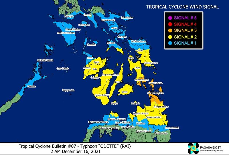
Tropical Cyclone Wind Signal (TCWS) No. 3 is hoisted over the following areas:
Visayas
- Southern Leyte
Mindanao
- Dinagat Islands
- Surigao del Norte
- the northern portion of Agusan del Norte (Tubay, Santiago, Jabonga, Kitcharao)
- the northern portion of Surigao del Sur (Carrascal, Cantilan, Madrid, Carmen, Lanuza, Cortes)
TCWS No. 2 is raised over the following areas:
Luzon
- the southern portion of Masbate (Cataingan, Pio V. Corpuz, Esperanza, Placer, Balud, Cawayan)
Visayas
- the central and southern portions of Eastern Samar (Guiuan, Salcedo, Quinapondan, Giporlos, Balangiga, Lawaan, General Macarthur, Hernani, Llorente, Balangkayan, Maydolong, City of Borongan, San Julian, Sulat, Taft, Can-Avid, Mercedes)
- the central and southern portions of Samar (Marabut, Basey, Santa Rita, Villareal, Pinabacdao, Calbiga, Hinabangan, Paranas, Motiong, Jiabong, City of Catbalogan, San Sebastian, Zumarraga, Daram, Talalora, San Jorge, Tarangnan, Pagsanghan, Santo Niño, Almagro, Tagapul-An)
- Biliran
- Leyte
- Cebu
- Bohol
- Negros Oriental
- Siquijor
- Negros Occidental
- Guimaras
- Iloilo
- Capiz
- the southern portion of Antique (Laua-An, Bugasong, Valderrama, San Remigio, Patnongon, Belison, San Jose, Sibalom, Hamtic, Tobias Fornier, Anini-Y)
Mindanao
- the rest of Surigao del Sur
- the rest of Agusan del Norte
- Agusan del Sur
- the northern portion of Bukidnon (Malitbog, Impasug-Ong, Manolo Fortich)
- Misamis Oriental
- Camiguin
- the extreme northern portion of Misamis Occidental (Sapang Dalaga, Baliangao, Plaridel, Calamba, Lopez Jaena, Oroquieta City)
- the extreme northern portion of Zamboanga del Norte (Dipolog City, Dapitan City, Sibutad, Rizal)
TCWS No. 1 is raised over the following areas:
- Luzon
- Catanduanes
- Camarines Sur
- Albay
- Sorsogon
- the rest of Masbate including Ticao and Burias Islands
- Marinduque
- Romblon
- the southern portion of Quezon (San Antonio, Tiaong, Candelaria, Sariaya, Dolores, Lucena City, Pagbilao, Padre Burgos, Atimonan, Agdangan, Unisan, Gumaca, Plaridel, Pitogo, Lopez, Guinayangan, Buenavista, Catanauan, General Luna, Macalelon, Mulanay, San Narciso, San Andres, San Francisco)
- the southern portion of Batangas (San Juan, Lobo, Taysan, Rosario, Padre Garcia, Ibaan, Batangas City, San Pascual, San Luis, Bauan, Mabini, Tingloy, Calatagan)
- Oriental Mindoro
- Occidental Mindoro
- the northern and central portions of Palawan (San Vicente, Roxas, Taytay, Dumaran, Araceli, El Nido, Puerto Princesa City) including Calamian, Cagayancillo and Cuyo Islands
Visayas
- Northern Samar
- the rest of Eastern Samar
- the rest of Samar
- Aklan
- Antique
- Capiz
- the rest of Iloilo
- Mindanao
- the northern portion of Davao Oriental (Boston, Cateel)
- the northern portion of Davao de Oro (Monkayo, Compostela, Montevista, Laak)
- the northern portion of Davao del Norte (San Isidro, Kapalong)
- the rest of Misamis Occidental
- the central portion of Bukidnon (Talakag, Lantapan, City of Valencia, City of Malaybalay, San Fernando, Cabanglasan, Libona, Baungon, Sumilao)
- the northern portion of Lanao del Norte (Baroy, Tubod, Kolambugan, Magsaysay, Tangcal, Munai, Maigo, Bacolod, Kauswagan, Poona Piagapo, Pantao Ragat, Matungao, Baloi, Iligan City, Linamon, Tagoloan, Pantar)
- the northern portion of Lanao del Sur (Madalum, Bacolod-Kalawi, Tugaya, Balindong, Piagapo, Saguiaran, Marantao, Marawi City, Kapai, Tagoloan II, Bubong, Ditsaan-Ramain, Buadiposo-Buntong)
- the northern portion of Zamboanga del Norte (Labason, Kalawit, Tampilisan, Liloy, Salug, Godod, Bacungan, Sindangan, Siayan, Jose Dalman, Manukan, Pres. Manuel A. Roxas, Katipunan, Sergio Osmeña Sr., Mutia, La Libertad, Gutalac, Baliguian, Piñan, Polanco)
- the northern portion of Zamboanga del Sur (Dumingag, Ramon Magsaysay, Midsalip, Sominot, Mahayag, Molave, Josefina, Tambulig)
HEAVY RAINFALL
On Thursday, heavy to intense with at times torrential rains over Caraga, Misamis Oriental, Camiguin, Southern Leyte, and Bohol.
Moderate to heavy with at times intense rains over Leyte, the southern portions of Eastern Samar and Samar, Cebu, Siquijor, Negros Oriental, Zamboanga del Norte, Lanao del Sur, and the rest of Northern Mindanao, Light to moderate with at times heavy rains over Bicol Region, Davao Oriental, Davao de Oro, Davao del Norte, and the rest of Visayas, Zamboanga Peninsula, and mainland Bangsamoro.
On Friday, Heavy to intense with at times torrential rains over Central Visayas, Western Visayas, and Palawan including Calamian Islands, Cuyo, and Cagayancillo Islands.
Moderate to heavy with at times intense rains over Bicol Region, Zamboanga Peninsula, Occidental Mindoro, Oriental Mindoro, Romblon, Lanao del Norte, Lanao del Sur, and the rest of Visayas.
Light to moderate with at times heavy rains over Caraga, Quezon, the southern portion of Aurora, and the rest of Northern Mindanao and MIMAROPA.
Residents in the affected areas are warned that scattered to widespread flooding, including flash floods and rain-induced landslides are expected especially in areas susceptible to these hazards.
SEVERE WINDS
Destructive typhoon-force winds will be experienced within any of the areas where TCWS No. 3 is in effect while damaging winds reaching gale- to storm-force strength will be experienced within any of the areas where TCWS No. 2.
Strong winds with higher gusts will be experienced within any of the areas where TCWS No. 1 is currently in effect during the passage of the typhoon.
COASTAL INUNDATION
There is a moderate to high risk of storm surge of up to 3.0 m in height which may cause flooding in the low-lying coastal areas of Central Visayas, Iloilo, Guimaras, Negros Occidental, Eastern Samar, Southern Leyte, Dinagat Islands, Surigao del Norte, Surigao del Sur, and several localities in the northern portion of Palawan including Calamian, Cuyo and Cagayancillo Islands, Antique, Camiguin, Leyte, Agusan del Norte, and Davao Oriental.
With Odette and the prevailing northeast monsoon, a Gale Warning remains in effect for several coastal waters not under any wind signal, specifically the seaboards of Northern Luzon, the eastern seaboard of Central Luzon, and the eastern seaboards of Southern Luzon and Mindanao.
TRACK AND INTENSITY OUTLOOK
Odette will move westward over the Philippine Sea and the center of its eye is forecast to make landfall in the vicinity of Dinagat Islands, Siargao-Bucas Grande Islands, or the northern portion of Surigao del Sur by Thursday afternoon.
The typhoon will continue moving generally westward and cross several provinces in Central and Western Visayas regions before emerging over the Sulu Sea by Friday morning.
Odette is expected to intensify up to 155 kph prior to landfall.
The public and disaster risk reduction and management offices concerned are advised to take all necessary measures to protect life and property. -- BAP, GMA News
