
Agaton keeps strength after landfall; Signal 2 up over 4 areas
Tropical Cyclone Wind Signal (TCWS) No. 2 was hoisted over four areas on Sunday after Tropical Storm Agaton made landfall in Eastern Samar, PAGASA said.
In its 11 a.m. bulletin, state weather bureau PAGASA said the following areas are under TCWS No. 2:
- southern portion of Eastern Samar (Guiuan, Mercedes, Salcedo, Quinapondan, Giporlos, Balangiga, Lawaan, General Macarthur, Hernani, Llorente, Balangkayan, Maydolong, Borongan City);
- southern portion of Samar (Marabut, Basey, Calbiga, Pinabacdao, Villareal, Santa Rita);
- northeastern portion of Leyte (Babatngon, Tacloban City, Palo, Tanauan, Tolosa)
- northern portion of Dinagat Islands (Loreto, Tubajon)
These areas have gale-force winds prevailing or may expect within the next 24 hours.
Winds may also result in minor to moderate threats to life and property, PAGASA said.
Meanwhile, TCWS No. 1 was hoisted over:
- the rest of Eastern Samar,
- the rest of Samar,
- Northern Samar,
- Biliran,
- the rest of Leyte,
- Southern Leyte,
- northeastern portion of Cebu (Daanbantayan, Medellin, Bogo City, Tabogon, Borbon, San Remigio) including Camotes Islands
- Surigao del Norte
- the rest of Dinagat Islands
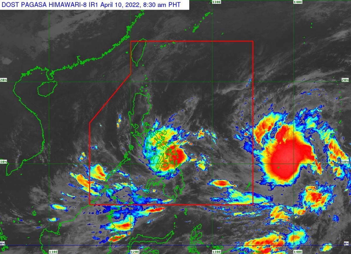
Storm Agaton made landfall over Calicoan Island in Guiuan at 7:30 a.m.
Strong winds prevailing or are expected in these areas within the next 36 hours.
As of 10 a.m., the center of Agaton was estimated at 10.9°N, 125.6°E over the coastal waters of Guiuan, Eastern Samar.
It has maximum sustained winds of 75 km/h near the center, gustiness of up to 105 km/h, and central pressure of 996 hPa.
PAGASA said Agaton was slowly moving westwards.
It also has strong winds or higher that extend outwards up to 220 km from the center.
Moreover, heavy to intense with at times torrential rains are expected over Eastern Visayas and Dinagat Islands.
Moderate to heavy with at times intense rains are expected over the Surigao del Norte, Agusan del Norte, Bohol, and Cebu.
Meanwhile, light to moderate with at times heavy rains are over Masbate, Sorsogon, Albay, Catanduanes, Romblon, Northern Mindanao, and the rest of Visayas and Caraga.
In the next 24 hours, rough to very rough seas (2.8 to 5.0 m) will prevail over the seaboards of areas where TCWS No. 2 and TCWS No. 1 are hoisted.
Since these conditions may be risky for most sea crafts, PAGASA advised mariners of small sea vessels to remain in port or take shelter, while those operating larger vessels are advised to take precautionary measures when venturing out to sea and, if possible, avoid navigating in these conditions.
Further, moderate to rough seas (1.2 to 3.4 m) will also prevail in the next 24 hours over the remaining seaboards of the country that are not under any wind signal or gale warning.
Tropical Storm Malakas
On the other hand, PAGASA is also monitoring another Tropical Storm Malakas which was estimated at 1,570 km East of Mindanao (10.7°N, 139.8°E) as of 10 a.m. on Sunday.
In a separate 11 a.m. bulletin, Malakas was reported to have a maximum sustained winds of 85 km/h near the center, gustiness of up to 105 km/h, and central pressure of 992 hPa.
Its present movement is northwestwards at 30 km/h, while its strong winds or higher extend up to 380 km from the center.
“Wala pa itong direktang epekto sa anumang bahagi ng ating bansa [it has no direct impact yet on any part of our country],” DOST-PAGASA Senior Weather Specialist Chris Perez explained.
PAGASA said that Malakas may enter the Philippine Area of Responsibility (PAR) by late Monday or early Tuesday.
It may also continue intensifying throughout the forecast period, reaching typhoon category by tomorrow morning. A peak intensity of 155 km/h may be reached on late Tuesday or early Wednesday.
“Its duration within the PAR region will likely be short as it is expected to leave the region by late Tuesday or early Wednesday. MALAKAS will then turn and accelerate northeastward or north northeastward beginning on Wednesday,” PAGASA said.
Stranded, canceled classes
Meanwhile, several passengers were left stranded on Sunday in Eastern Visayas ports due to delayed sea travels caused by Storm Agaton.
Interviewed in Super Radyo dzBB, Assistant Regional Director Office of Civil Defense Region 8 Rey Gozon said at least 120 passengers and 65 vehicles at Liloan Port Ferry Terminal bound for Mindanao were unable to leave.
Also, Gozon said 92 passengers and 59 vehicles were stranded at Port of San Ricardo.
Some classes for Monday, April 11, were also canceled due to the storm.
A total of 3,347 individuals have evacuated in Cagayan de Oro and Bukidnon province due to rain-induced landslides, and flooding caused by Agaton, the National Disaster Risk Reduction and Management Council said Sunday. —LBG/KG, GMA News
