
Domeng slightly intensifies, enhances habagat, monsoon trough to bring rains over parts of Luzon
The monsoon trough and the southwest monsoon enhanced by Tropical Depression Domeng and Tropical Storm Chaba (formerly Caloy), which is outside the Philippine Area of Responsibility (PAR), will bring monsoon rains over the western sections of Central and Southern Luzon, PAGASA reported in its Tropical Cyclone Bulletin posted at 5 a.m. on Friday.
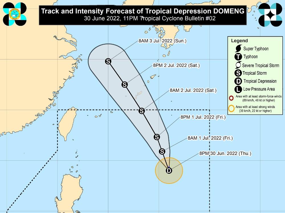
The center of Tropical Depression Domeng, which slightly intensified while slowly moving southward, is estimated at 1,000 kilometers east of extreme northern Luzon with maximum sustained winds of 55 kilometers per hour near the center, gustiness of up to 70 km/h, and central pressure of 1000 hPa.
No tropical cyclone wind signal is currently hoisted for this tropical cyclone.
But the southwest monsoon is enhanced by Domeng and Chaba and will bring occasionally gusty conditions reaching strong breeze to near gale in strength over extreme northern Luzon, the northern and western portions of Luzon, and the western portion of Visayas.
A Gale Warning, meanwhile, remains in effect over the western seaboards of Luzon while moderate to rough seas is expected over the remaining seaboards of northern Luzon.
The sea conditions may be risky for small seacrafts, so mariners are advised to take precautionary measures when venturing out to sea and may opt to avoid navigating in these conditions.
Track and Intensity outlook
Domeng is forecast to gradually accelerate north northwestward over the next three days and remain far from the Philippine landmass and may exit the PAR on Saturday (2 July) morning or afternoon.
Outside the PAR, Domeng is forecast to pass very close or make landfall in the vicinity of the Ryukyu Islands on Saturday evening or Sunday (3 July) morning.
Based on the 4 a.m. daily forecast, however, Zambales, Bataan, Occidental Mindoro, and Palawan will have monsoon rains brought about by the southwest monsoon with possible flash floods or landslides due to scattered to widespread moderate to at times heavy rains.
Metro Manila, Ilocos Region, Cordillera Administrative Region (CAR), CALABARZON, Western Visayas, and the rest of Central Luzon and MIMAROPA will have cloudy skies with scattered rain showers and thunderstorms also due to the southwest monsoon with possible flash floods or landslides due to moderate to at times heavy rains.
The rest of the country will have partly cloudy to cloudy skies with isolated rain showers or thunderstorms due to localized thunderstorms with possible flash floods or landslides during severe thunderstorms.
The wind speed forecast for the northern and western sections of Luzon is moderate to strong moving in the southwest to southeast direction while coastal waters will be moderate to strong.
The rest of the country will experience light to moderate wind speed moving in the southwest to southeast direction while coastal waters will be slight to moderate.
Sunrise will be at 5:31 a.m., sunset at 6:29 p.m. -- BAP, GMA News
