

Ester slows down over Philippine Sea, enhances Habagat which will bring rains
Tropical Depression Ester has slowed down over the Philippine Sea early Saturday, but it is enhancing the Southwest Monsoon (Habagat) which will bring rains over portions of the western sections of Southern Luzon, including Metro Manila, and Visayas, PAGASA said in its 5 a.m. bulletin.
The monsoon is also being enhanced by Tropical Storm Songda which is outside the Philippine Area of Responsibility (PAR).
PAGASA said no tropical cyclone wind signal has been hoisted for Ester.
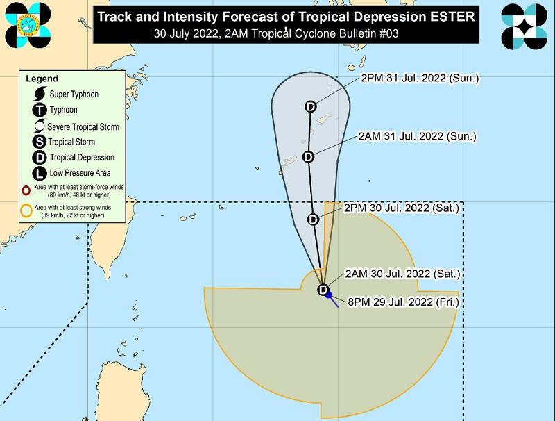
As of 10 p.m. Friday, Ester's eye or center was located at 785 kilometers east of Itbayat, Batanes.
It has maximum sustained winds of 45 kilometers per hour near the center, gustiness of up to 55 km/h, and central pressure of 1000 hPa.
Ester is moving slowly in the north northwest direction.
From its center, strong winds are extending outwards up to 600 km.
Heavy rains
In the next 24 hours, the monsoon enhanced by Ester and Songda will bring light to moderate with at times heavy rains over several provinces in the western sections of southern Luzon including Metro Manila and Visayas.
Metro Manila, Calabarzon, Mimaropa, Bicol Region, Zambales, Bataan, Aklan, Antique, and Samar Provinces will have cloudy skies with scattered rain showers and thunderstorms. Flash floods or landslides may occur due to moderate to at times heavy rains.
The rest of the country will have partly cloudy to cloudy skies with isolated rain showers or thunderstorms due to the monsoon and localized thunderstorms. PAGASA said flash floods or landslides may possibly occur during severe thunderstorms.
Hazards affecting coastal waters
Coastal waters will be moderate to rough over the northern and eastern seaboards of the country due to Ester and the monsoon.
Sea travel will be risky for those using small seacraft.
"Mariners are advised to take precautionary measures when venturing out to sea and, if possible, avoid navigating in these conditions," PAGASA said.
Track and intensity outlook
Ester is forecast to move generally northward to north northwestward and may exit the PAR on Saturday afternoon.
"Outside the PAR region, the tropical cyclone is forecast to pass very close or make landfall in the vicinity of the Ryukyu Islands tonight or tomorrow early morning," PAGASA said.
The weather bureau advised the public and disaster risk reduction and management offices concerned to take the necessary precautions.
The next weather bulletin will be issued at 11 a.m., PAGASA said. —BAP/KG, GMA News
