

PAGASA: Typhoon Hinnamnor seen to enter PAR Wednesday night
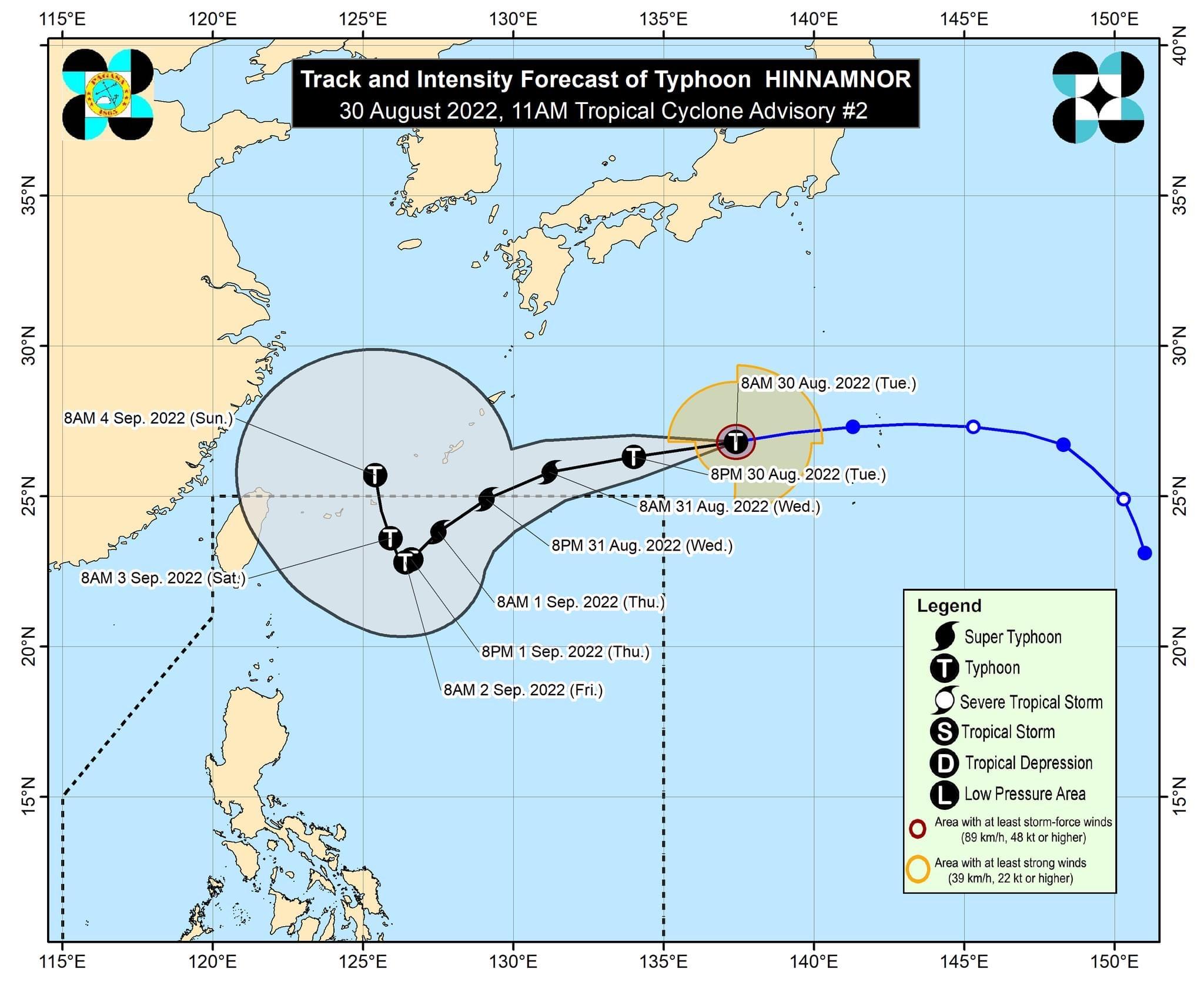
Typhoon Hinnamnor has maintained its strength while moving west and is expected to enter the Philippine Area of Responsibility (PAR) by Wednesday evening, PAGASA said Tuesday.
The domestic name Henry will be assigned to the tropical cyclone once inside the PAR.
In its 11 a.m. bulletin, the state weather bureau said the center of the eye of Hinnamnor was last spotted 1,655 km east northeast of extreme Northern Luzon (26.8°N, 136.7°E).
It has maximum sustained winds of 165 km/h near the center, gustiness of up to 205 km/h, and central pressure of 945 hPa.
PAGASA said Hinnamnor’s present movement is westward at 30 km/h.
It also has strong typhoon-force winds extending outwards up to 320 km from the center.
The typhoon may, however, continue to rapidly intensify over the sea south of Japan and reach the Super Typhoon category within 24 hours, PAGASA said.
On Tuesday, Hinnamnor will move generally westward over the sea south of Japan, then it will turn west-southwestward on Wednesday while decelerating over the sea southeast of the Ryukyu Islands.
Its further deceleration is expected as it turns more southwestward over the northern Philippine Sea.
By Friday to Saturday, Hinnamnor may become almost stationary, PAGASA added.
“The extent of tropical cyclone winds of “HINNAMNOR” may continue to expand in the coming days as it moves towards the northern Philippine Sea. As such, the possibility of hoisting a Tropical Cyclone Wind Signal over extreme Northern Luzon during the occurrence of this typhoon within the PAR region is not ruled out,” the state weather bureau said.
PAGASA said the typhoon may bring rough seas over the northern and eastern seaboard of Luzon beginning late Thursday or early Friday.
This may thus be risky for those using small seacrafts, while mariners are advised to continue monitoring for updates.
Low pressure area
In a separate weather advisory, PAGASA said a low pressure area (LPA) was estimated at 1,235 km east of extreme Northern Luzon (20.0°N, 133.8°E) as of 10 a.m. on Tuesday.
This weather disturbance may develop into a tropical depression within 24 hours, it added.
The trough of the LPA will also bring cloudy skies with scattered rainshowers and thunderstorms over Aurora, Calabarzon, and Camarines Norte.—AOL, GMA News
