
Gardo maintains strength while moving west-southwest of PHL
Tropical Depression Gardo has maintained its strength while continuously moving in the west-southwest direction over the Philippine waters, PAGASA reported late Tuesday evening.
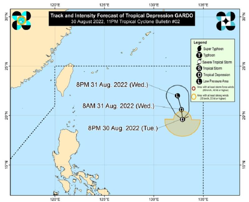
In its 11 PM bulletin, the state weather bureau said the center of the eye of Gardo was last spotted 1,125 kilometers east of extreme Northern Luzon at 10 p.m. today and heading west-southwestward at 10 kilometers per hour while packing maximum sustained winds of 55 km/h near the center and gustiness of up to 70 km/h.
No storm signal was raised in the country as PAGASA said the tropical cyclone is unlikely to directly affect both the weather condition and sea conditions in the Philippines within the forecast period.
On the forecast track, PAGASA said Gardo is forecast to move generally northward or north-northwestward and will interact with Super Typhoon Hinnamnor.
Gardo may also intensify into a tropical storm within the next 12 hours but is expected to degenerate into a remnant low by Wednesday afternoon or evening as Hinnamnor begins to assimilate its circulation.
Super Typhoon Hinnamnor further intensifies
In a separate advisory, PAGASA said Hinnamnor further intensified over the east of the Ryukyu Islands in Japan.
The center of the eye of Hinnamnor was last seen 1,305 km east northeast of extreme northern Luzon at 10 PM. It is moving west-southwestward at 30 km/h and has maximum sustained winds of 195 km/h near the center, gustiness of up to 240 km/h, and a central pressure of 925 hPa .
According to the weather bureau, the tropical cyclone is forecast to enter the Philippine Area of Responsibility (PAR) by Wednesday evening or Thursday, September 1, and will be given the local name “Henry”.
It is expected to decelerate while heading west-southwestward over the sea southeast of the Ryukyu Islands from Wednesday to Friday. Hinnamnor may further decelerate over the northern Philippine Sea and may become almost stationary by late Thursday through Friday, September 2.
Hinnamnor may reach a peak intensity of 205 km/h within 24 hours before gradually weakening as it enters its quasi-stationary phase. This tropical cyclone may be downgraded to the typhoon category by Friday.
PAGASA said light to moderate with at times heavy rains associated with the outermost rainbands of the super typhoon may affect Extreme Northern Luzon beginning on late Thursday or Friday.
The tropical cyclone may also enhance the Southwest Monsoon (Habagat) and bring monsoon rains over the western section of Luzon beginning on Friday.
Due to its effect on the sea conditions, PAGASA warned rough seas may be experienced over the northern and eastern seaboard of Luzon beginning late Thursday or early Friday.
“Such conditions may be risky for those using small seacrafts. Mariners are advised to continue monitoring for updates,” the agency said.
