

Trough of Henry, Habagat to bring cloudy skies, rains over NCR, 10 other areas
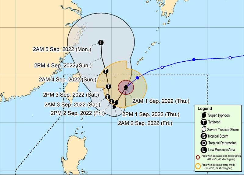
Super Typhoon Henry has maintained its strength as it moves southwestward over the Philippine Sea, according to the Tropical Cyclone Bulletin PAGASA posted early Thursday morning.
The center of the eye of Super Typhoon Henry was estimated at 530 kilometers east northeast of Itbayat, Batanes, with maximum sustained winds of 185 kilometers per hour near the center, gustiness of up to 230 km/h, and central pressure of 930 hPa.
The cyclone is moving southwestward at the speed of 25 km/h, PAGASA said.
Henry is also forecast to enhance the Southwest Monsoon or Habagat, which may bring rains over the western section of Luzon on Friday.
Winds and hazards affecting coastal waters
PAGASA said Metro Manila, Ilocos Region, Cordillera Administrative Region, CALABARZON, MIMAROPA, Bicol Region, Western Visayas, Batanes, Cagayan, Zambales, and Bataan will have cloudy skies with scattered rain showers and thunderstorms brought about by the Trough of Henry and the Southwest Monsoon or Habagat with possible flash floods or landslides due to moderate to at times heavy rains.
The rest of the country will have partly cloudy to cloudy skies with isolated rain showers or thunderstorms due to localized thunderstorms with possible flash floods or landslides during severe thunderstorms, it added.
The wind speed forecast for northern Luzon is strong moving in the northwest to west direction while coastal waters will be rough.
The rest of the country will experience light to moderate wind speed moving in the west to southwest direction while coastal waters will be slight to moderate.
The extent of Tropical Cyclone Winds is strong to typhoon-force winds extending outwards up to 340 km from the center.
A gale warning is in effect for the northern and eastern seaboards of Northern Luzon.
"In the next 24 hours, Henry may bring moderate to rough seas over the eastern seaboard of Isabela (1.2 to 4.0 m). These conditions may be risky for those using small seacrafts. Mariners are advised to take precautionary measures when venturing out to sea and, if possible, avoid navigating in these conditions," PAGASA also reported.
Henry is forecast to continue moving generally southwestward today through early Friday morning while decelerating. By Thursday evening or early Friday morning, Henry may become almost stationary and expected to accelerate by Saturday and exit the Philippine Area of Responsibility by Saturday evening.
TD Gardo
Tropical Depression Gardo, meanwhile, continues to maintains its strength as it moves northwestward east northeast of extreme northern Luzon.
The center of Gardo was estimated at 885 kilometers east northeast of extreme northern Luzon with maximum sustained winds of 55 km/h near the center, gustiness of up to 70 km/h, central pressure of 1000 hPa, moving northwestward at the speed of 45 km/h.
The extent of strong winds extend outwards up to 200 km from the center.
PAGASA said Gardo is not likely to have a direct impact on the weather condition in the country and the sea conditions over the coastal waters.
It is forecast to move northwestward to westward over the Philippine Sea east northeast of Extreme Northern Luzon as it merges itself with the larger circulation of Henry. Gardo is forecast to weaken into a low-pressure area within 12 hours or sooner.
Sunrise will be at 5:44 a.m., sunset at 6:08 p.m. -- BAP/RSJ, GMA News
