

Inday's trough to bring rain showers over Calabarzon, Mimaropa, 4 other areas
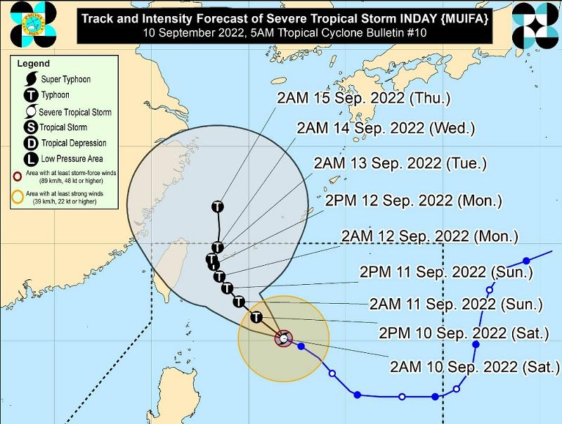
Severe Tropical Storm Inday (international name: Muifa) maintained its strength on Saturday as it continued moving west northwestward, and its trough will bring rains over parts of the country, PAGASA said in its early morning bulletin.
At 4 a.m., the center of Inday was estimated at 495 kilometers east of Basco, Batanes, packing maximum sustained winds of 110 kilometers per hour near the center with gustiness of up to 135 km/h and central pressure of 992 hPa.
Inday is moving west northwestward at the speed of 20 km/h.
Strong to storm-force winds are extending outwards up to 260 km from the center.
Heavy rainfall
Inday remains less likely to directly bring heavy rains in the country but its trough may bring heavy rain showers during thunderstorms over Southern Luzon and the western portions of Central Luzon and Visayas.
Calabarzon, Mimaropa, Bicol Region, Western Visayas, Bataan, and Zambales will have cloudy skies with scattered rain showers and thunderstorms due to Inday's trough. Flash floods or landslides may result due to moderate to at times heavy rains.
Metro Manila and the rest of the country will have partly cloudy to cloudy skies with isolated rain showers or thunderstorms due to localized thunderstorms, with possible flash floods or landslides during severe thunderstorms.
In the next 24 hours, Inday may bring moderate to rough seas over the seaboards of Batanes and Babuyan Islands, making it risky for small seacraft. Mariners were advised to monitor updates and be cautious when venturing out to sea.
Inday is forecast to move generally northwestward over the Philippine Sea on Saturday through Monday as it tracks towards the sea east of Taiwan.
It is expected to reach a quasi-stationary state by Tuesday, then exit the Philippine Area of Responsibility (PAR) and pass close to the Miyako or Yaeyama Islands in Japan by late Tuesday or early Wednesday.
The public and disaster risk reduction and management offices concerned are advised to take all necessary measures while persons living in areas identified to be highly or very highly susceptible to these hazards are advised to follow evacuation and other instructions from local officials.
Sunrise will be at 5:45 a.m., while sunset will be at 6:02 p.m. —BAP/KG, GMA News
