

Signal No. 1 raised over eastern Isabela, northern Aurora as Karding moves southwestward
Tropical Storm Karding maintained its strength as it moves southwestward over the Philippine Sea, weather bureau PAGASA said Friday.
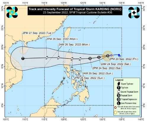
In its latest bulletin, PAGASA said the center of the eye of Karding was located 895 kilometers east of Northern Luzon packing maximum sustained winds of 75 km/h near the center, gustiness of up to 90 km/h, and heading southwestward at the speed of 15 kilometers per hour.
Tropical Cyclone Wind Signal No. 1 has been raised over the following areas:
- the eastern portion of Isabela (Divilacan, Palanan, Dinapigue, Maconacon, San Mariano, Ilagan City)
- the northern portion of Aurora (Casiguran, Dilasag, Dinalungan)
However, Karding will partly influence the prevailing Southwest Monsoon (Habagat) bringing occasional rains over Metro Manila, most of Southern Luzon, and the Visayas region beginning Saturday evening up to Sunday.
On the forecast track, PAGASA reports that Karding is expected to move generally westward while gradually accelerating towards the east coast of Isabela or Aurora, where it is likely to make landfall on Sunday morning or afternoon.
It may reach the severe tropical storm category prior to its landfall but the weather bureau said it is not ruling out the possibility it will intensify into a typhoon before reaching the country’s landmass.
PAGASA said the frictional effects of the rugged terrain of Northern Luzon may slightly weaken Karding but it will likely remain in the severe tropical storm category once it emerges over the West Philippine Sea. -- BAP, GMA News
