

LPA now Tropical Depression Obet; shear line to bring rains over Batanes, 3 areas
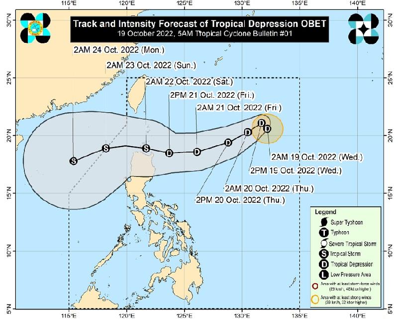
The Low Pressure Area (LPA) east of extreme Northern Luzon has developed into Tropical Depression Obet at 2 a.m. on Wednesday, PAGASA reported in its early morning forecast.
At 3 a.m., the center of Tropical Depression Obet was estimated at 1,045 kilometers east of Extreme Northern Luzon with maximum sustained winds of 45 kilometers per hour near the center, gustiness of up to 55 km/h, and moving north northwestward at 10 km/h.
The shear line, meanwhile, will be affecting extreme Northern Luzon.
There are no Tropical Cyclone Wind Signals raised at this time.
Batanes, Cagayan including Babuyan Islands, Ilocos Norte and Apayao will have cloudy skies with scattered rain showers and thunderstorms brought about by the shearline with possible flash floods or landslides due to moderate to at times heavy rains.
Eastern Visayas will have cloudy skies with scattered rain showers and thunderstorms due to the Southwesterly Surface Windflow with possible flash floods or landslides due to moderate to at times heavy rains.
Metro Manila and the rest of the country will have partly cloudy to cloudy skies with isolated rain showers or thunderstorms due to localized thunderstorms and Southwesterly Surface Windflow with possible flash floods or landslides during severe thunderstorms.
The weather bureau is also monitoring an active tropical cyclone, which is outside the Philippine Area of Responsibility (PAR). Typhoon Nesat (formerly Neneng) is located 940 kilometers west of northern Luzon with maximum sustained winds 120 km/h near the center, gustiness up to 150 km/h, moving west southwestward at 15km/h.
The wind speed for northern Luzon is moderate to strong moving northeast to east direction while coastal waters will be moderate to rough.
The rest of Luzon will have light to moderate wind speed moving in the southwest to southeast while coastal waters will be slight to moderate.
Visayas and Mindanao will experience light to moderate wind speed moving in the southeast to southwest with slight to moderate coastal waters.
"In the next 24 hours, the combined effects of the surge of northeasterly surface wind flow and the approaching tropical cyclone may also bring moderate to rough seas over the seaboards of Central Luzon and the western and eastern seaboards of Southern Luzon," said PAGASA, adding that these conditions may be risky for small seacrafts so precautionary measures should be implemented.
"Obet is forecast gradually intensify by mid Friday as it tracks closer to Extreme Northern Luzon and may reach tropical storm category by late Friday or early Saturday. Further intensification is likely once Obet reaches the West Philippine Sea," the bureau also reported.
Sunrise will be at 5:48 a.m., sunset at 5:34 p.m. -- BAP, GMA News
